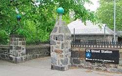
175th Street (IND Eighth Avenue Line)
| 175th Street | |||||||
|---|---|---|---|---|---|---|---|
| New York City Subway rapid transit station | |||||||
 | |||||||
| Station statistics | |||||||
| Address |
West 175th Street & Fort Washington Avenue New York, NY 10033 | ||||||
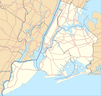
| Borough | Manhattan | ||||||
| Locale | Washington Heights | ||||||
| Coordinates | 40°56′48″N 73°56′24″W / 40.946541°N 73.940091°WCoordinates: 40°56′48″N 73°56′24″W / 40.946541°N 73.940091°W | ||||||
| Division | B (IND) | ||||||
| Line | IND Eighth Avenue Line | ||||||
| Services |
A | ||||||
| Transit connections |
| ||||||
| Structure | Underground | ||||||
| Platforms | 1 island platform | ||||||
| Tracks | 2 | ||||||
| Other information | |||||||
| Opened | September 10, 1932[1] | ||||||
| Accessible |
| ||||||
| Wireless service |
| ||||||
| Former/other names | 175th Street – George Washington Bridge Bus Terminal | ||||||
| Traffic | |||||||
| Passengers (2015) |
4,197,373[3] | ||||||
| Rank | 119 out of 422 | ||||||
| Station succession | |||||||
| Next north |
181st Street: A | ||||||
| Next south |
168th Street: A | ||||||
|
| |||||||
| Next |
Inwood – 207th Street: A | ||||||
| Next |
168th Street: A | ||||||
| |||||||
| |||||||

175th Street (also known as 175th Street – George Washington Bridge Bus Terminal) is a station on the IND Eighth Avenue Line of the New York City Subway. Located in the neighborhood of Washington Heights in Upper Manhattan, at 175th Street and Fort Washington Avenue, it is served by the A train at all times.
Station layout
| G | Street Level | Exit/Entrance |
| M | Mezzanine | Fare control, station agent |
| P Platform level |
Northbound | ← |
| Island platform, doors will open on the left | ||
| Southbound | → | |
The station opened on September 10, 1932.[1][4] It has two tracks and one island platform, with single green columns in the center of the platform rather than the double columns found near the platform edges at other stations. The tilework in this station is plain, and the station lacks the maroon-colored tile bands that are present at adjacent stations along the line.
It is linked by an underground tunnel to the George Washington Bridge Bus Station. The tunnel, which is maintained by the Port Authority of New York and New Jersey, is not wheelchair-accessible, as using it requires traversing a short flight of stairs between the tunnel and the station mezzanine. This tunnel is closed at night between 1 a.m. and 5 a.m.[5]
The 174th Street Yard, used to store trains assigned to the C service, is adjacent to this station to the east.
The station is planned to be rehabilitated as part of the 2015–2019 MTA Capital Program.[6]
Exits
The full-time exits are at 175th Street and 177th Street. The station is fully accessible, with an elevator at the northeast corner of 177th Street and another from the mezzanine to the platform.[7] The elevators were installed during a 1990s Americans with Disabilities Act renovation, and features one of the system's oldest ADA elevators.
 Exits at the northwest, northeast, and southwest corners of Fort Washington Avenue and 177th Street. The northwest corner has two stairs, the southwest corner has one stair, and the northeast corner has one stair and one elevator.[7]
- Exits at the southwest and southeast corners of Fort Washington Avenue and 175th Street.[7]
Bus service
The station and the nearby George Washington Bridge Bus Terminal are served by ten local MTA Regional Bus Operations routes and various interstate bus routes.[8][9]
| Route | Operator | North/West Terminal | South/East Terminal | via | notes |
|---|---|---|---|---|---|
| Local Bus Routes | |||||
| M4 | New York City Bus | The Cloisters or Fort Tryon Park | Penn Station | Broadway and Fifth Avenue | Bus only runs to the Cloisters when the museum is open; it only runs to Fort Tryon Park at all other times. |
| M5 | New York City Bus | Broadway at West 179th Street | South Ferry | Riverside Drive, Fifth Avenue, and Broadway | |
| M98 LTD | New York City Bus | Fort Tryon Park | 68th Street/Lexington Avenue | Harlem River Drive and Lexington Avenue | Bus only runs during rush hours. |
| M100 | New York City Bus | West 220th Street/Broadway, Inwood | East 125th Street/First Avenue, East Harlem | Broadway and Amsterdam Avenues | |
| Bx3 | New York City Bus | 238th Street station, Riverdale, Bronx | West 179th Street east of Broadway | University Avenue | |
| Bx7 | New York City Bus | West 263rd Street/Riverdale Avenue, Riverdale, Bronx | 168th Street station | Broadway, Johnson Avenue, Henry Hudson Parkway | |
| Bx11 | New York City Bus | West 179th Street west of Broadway | Simpson Street station, Longwood, Bronx | 170th Street | |
| Bx13 | New York City Bus | West 179th Street west of Broadway | Bronx Terminal Market (extended to Third Avenue/163rd Street, rush hours) | Ogden Avenue and Yankee Stadium | |
| Bx35 | New York City Bus | West 179th Street east of Broadway | Simpson Street station, Longwood, Bronx | 167th & 169th Street's | |
| Bx36 | New York City Bus | West 179th Street west of Broadway | Olmstead Avenue/Seaward Avenue, Castle Hill, Bronx | 174/180th Streets | |
| Other bus routes | |||||
| George Washington Bridge Bus Terminal routes | Various | George Washington Bridge Bus Terminal | |||
References
- 1 2 New York Times, List of the 28 Stations on the New Eighth Ave Line, September 10, 1932, page 6
- ↑ "NYC Subway Wireless – Active Stations". Transit Wireless Wifi. Retrieved 2016-05-18.
- ↑ "Facts and Figures: Annual Subway Ridership". Metropolitan Transportation Authority. Archived from the original on 2013-05-28. Retrieved 2016-04-18.
- ↑ Crowell, Paul (September 10, 1932). "Gay Midnight Crowd Rides First Trains In The New Subway: Throngs at Station an Hour Before Time, Rush Turnstiles When Chains are Dropped". New York Times. Retrieved 8 November 2015.
- ↑ "Connections - George Washington Bridge Bus Station - The Port Authority of NY & NJ". www.panynj.gov. Retrieved 2016-07-30.
- ↑ "Review of the A and C Lines" (PDF). Metropolitan Transportation Authority. December 11, 2015. Retrieved 19 January 2016.
- 1 2 3 "MTA Neighborhood Maps: Washington Heights" (PDF). Metropolitan Transportation Authority. 2015. Retrieved 29 July 2016.
- ↑ "Manhattan Bus Map" (PDF). Metropolitan Transportation Authority. 2016. Retrieved 2016-07-29.
- ↑ "Bronx Bus Map" (PDF). Metropolitan Transportation Authority. 2016. Retrieved 2016-07-29.
External links
| Wikimedia Commons has media related to 175th Street (IND Eighth Avenue Line). |
- nycsubway.org – IND Eighth Avenue Line: 175th Street/George Washington Bridge Bus Terminal
- Station Reporter — A Lefferts
- Station Reporter — A Rockaway
- The Subway Nut — 175th Street–George Washington Bus Terminal
- 175th Street entrance from Google Maps Street View
- Fort Washington Avenue entrance from Google Maps Street View
- 177th Street entrance from Google Maps Street View
- Platform from Google Maps Street View