1916 Texas hurricane
| Category 4 major hurricane (SSHWS/NWS) | |
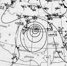
 Surface weather analysis of the hurricane nearing landfall on August 18 | |
| Formed | August 12, 1916 |
|---|---|
| Dissipated | August 20, 1916 |
| Highest winds |
1-minute sustained: 135 mph (215 km/h) |
| Lowest pressure |
932 mbar (hPa); 27.52 inHg (Estimated) |
| Fatalities | 24 |
| Damage | $28.6 million (1916 USD) |
| Areas affected | |
| Part of the 1916 Atlantic hurricane season | |
The 1916 Texas hurricane brought an extensive swath of destruction stretching from the Lesser Antilles westward to South Texas. An intense Category 4 hurricane at its peak, until 1919 the hurricane was the strongest tropical cyclone to strike anywhere in the United States since the 1886 Indianola hurricane in terms of its barometric pressure. Although the storm's greatest impacts were in Texas, considerable damage was wrought on Jamaica, with minimal impacts in the Lesser Antilles and the Yucatan Peninsula. Over its eight-day trek across the Caribbean Sea and Gulf of Mexico, the intense hurricane caused 24 deaths and accrued US$28.6 million in damage.[nb 1]
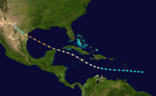
The tropical cyclone developed as a tropical storm east of Barbados on August 12 based on ship and insular observations in the vicinity of the storm at the time. Tracking westward, the tropical cyclone gradually intensified and reached hurricane strength on August 15 shortly before making landfall on Jamaica as a minimal hurricane. Additional strengthening occurred as the storm traversed the Yucatán Channel as a major hurricane on August 17.[nb 2] In the Gulf of Mexico, the storm reached its peak intensity as a Category 4 hurricane with maximum sustained winds of 135 mph (215 km/h); the hurricane made landfall near Baffin Bay, Texas with this intensity late on August 18. After moving inland, the tropical cyclone rapidly diminished and dissipated on August 20 over West Texas.
Meteorological history

At 06:00 UTC on August 12,[2] ship observations near Barbados indicated that a westward-moving trough of low pressure had become sufficiently organized to be considered a tropical storm.[3] A possible precursor disturbance as indicated by low barometric pressures and strong winds was observed by ships as early as August 8 and as far east as the coast of Senegal. However, during this time these observations were inconclusive in regards to determining the formation of a tropical cyclone.[4] Tracking steadily westward, the tropical storm gradually intensified and reached hurricane intensity on August 15 while south of Hispaniola.[2][3] Over the following few days, the hurricane curved slightly more northward. This new trajectory brought the storm to a landfall on the south-central coast of Jamaica with maximum sustained winds of 80 mph (130 km/h) at around 18:00 UTC on August 15.[2] In Kingston, Jamaica, the lowest documented pressure was 1006 mbar (hPa; 29.71 inHg).[4]
After passing Jamaica, the hurricane continued to gradually intensify, and tracked through the Yucatán Channel on August 17. At 12:00 UTC that day, the storm reached major hurricane strength just north of the Mexican state of Quintana Roo. Although ship observations in the area that day were sparse and at the most only suggested a cyclone of minimal tropical storm strength, the hurricane's official intensity based on previous intensification trends.[3] The next day, the storm strengthened further to the equivalent of a Category 4 hurricane on the modern day Saffir–Simpson hurricane wind scale. This trend of intensification continued up until 22:00 UTC on August 18, when the hurricane made landfall near Baffin Bay, Texas. At this time, the tropical cyclone reached its peak intensity with winds of 135 mph (215 km/h) and a minimum barometric pressure estimated at 932 mbar (hPa; 27.52 inHg).[3] In terms of pressure, this made the 1916 Texas hurricane stronger than any other landfalling tropical cyclone in the United States since 1886 until it was surpassed by the 1919 Florida Keys hurricane.[5] After landfall,[3] the hurricane quickly decayed over South Texas and was last noted as a tropical depression near McCamey in West Texas on August 20.[2]
Preparations and impact

Passing through the Lesser Antilles from August 12–13, the developing tropical cyclone produced gusty winds, peaking at 25 mph (35 km/h) on Antigua and reaching minimal tropical storm intensity on offshore locations. In San Fernando, Trinidad and Tobago, a station documented 0.42 in (11 mm) of rain from the storm.[4] However, no damage resulted from the weak disturbance as it passed the islands.[3] However, as a definite tropical cyclone was ascertained in the eastern Caribbean Sea, the United States Weather Bureau issued a warning to shipping in the region on August 13.[6] Continued issuance of marine warnings continued as the hurricane progressed westward across the Caribbean, with warning of hurricane-force winds being issued for the Yucatan Channel near Cuba's Guanahacabibes Peninsula on August 16.[7]
At 7 am (CST), local weather officials issued hurricane warnings to coastal sections. Telegraphs of the warnings were then sent out to Cameron and Calhoun counties. Over 100 vehicles were used to transport residents to storm shelters.[8]
Jamaica
Making landfall on Jamaica on August 15 as a minimal hurricane, the island felt the impacts of strong winds and tropical rainfall. In Kingston, a station measured 1.56 in (40 mm) of precipitation from the hurricane.[4] Rough surf generated by the strong winds grounded vessels and lighters on the shores of Kingston Harbour. Two people drowned offshore due to the intense wave action. In Kingston, telecommunication lines were blown down, making the dissemination of damage reports in Jamaica increasingly difficult.[9] Extensive property damage occurred throughout the capital city. Considerable damage was wrought to banana plantations, while sugar cane and coconut crops did not sustain significant impacts.[9] The American consulate on the island reported that the entirety of Jamaica's banana crop was damaged to some extent.[10]
Texas
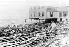
In Texas, tropical storm force winds of 64–70 mph were felt as the hurricane neared land. A gust of 90 mph (140 km/h) was reported at 6:50 pm (CST) as the hurricane made landfall. Rainfall totals from the hurricane was estimated at 1.58 inches (25.4 mm). The hurricane damaged some of the measuring equipment at the National Weather Service office. Offshore, a fishing boat sank, drowning two of its occupants. On land, five people perished during the storm; two from a house collapsing. In Corpus Christi, the hurricane destroyed several wharfs and salt cedars.[8] In Fort Brown, the flooding from the hurricane forced United States Army soldiers and National Guardsmen to seek refuge in city hall after their barracks were flooded.[11] The storm left $1.6 million (1916 USD) in damage in Texas.[8] In all the hurricane left $28.6 million (1916 USD) in damage and 24 people dead.
See also
| Wikimedia Commons has media related to 1916 Texas hurricane. |
- List of Texas hurricanes (1900–1949)
- Hurricane Allen – Struck South Texas after tracking across the Caribbean Sea
- Hurricane Beulah – Intense Category 5 hurricane which moved through the Yucatan Peninsula before striking South Texas
- 1919 Florida Keys hurricane – Deadly tropical cyclone which devastated areas of the Florida Keys and Texas
- Hurricane Bret (1999) – Quickly intensified in the western Gulf of Mexico before making landfall on a relatively unpopulated extent of the Texas coast
Notes
- ↑ All monetary values are in 1916 United States dollars unless otherwise noted.
- ↑ A major hurricane is a storm that ranks as Category 3 or higher on the Saffir–Simpson hurricane scale.[1]
References
- ↑ Goldenburg, Stan (June 1, 2014). "A3) What is a super-typhoon? What is a major hurricane? What is an intense hurricane?". Frequently Asked Questions (FAQ). 4.7. United States National Oceanic and Atmospheric Administration's Atlantic Oceanographic and Meteorological Laboratory. Retrieved August 20, 2014.
- 1 2 3 4 National Hurricane Center; Hurricane Research Division (July 6, 2016). "Atlantic hurricane best track (HURDAT version 2)". United States National Oceanic and Atmospheric Administration. Retrieved December 5, 2016.
- 1 2 3 4 5 6 Landsea, Chris; et al. (April 2014). "Documentation of Atlantic Tropical Cyclones Changes in HURDAT". National Hurricane Center. Retrieved August 20, 2014.
- 1 2 3 4 Atlantic Oceanographic and Meteorological Laboratory. "Observations for 1911 Storm #6" (.xls). Raw Tropical Storm/Hurricane Observations. United States National Oceanic and Atmospheric Administration's National Weather Service. Retrieved August 20, 2014.
- ↑ Hurricane Research Division (2013). "Chronological List of All Hurricanes: 1851 – 2013". Miami, Florida: United States National Oceanic and Atmospheric Administration's Atlantic Oceanographic and Meteorological Laboratory. Retrieved August 20, 2014.
- ↑ "Gulf Warned That A Storm Is Coming". Arkansas City Daily Traveler. 32 (123). Arkansas City, Arkansas. August 13, 1916. p. 1. Retrieved August 20, 2014 – via Newspapers.com.

- ↑ "Hurricane Headed Towards Texas". The Charlotte Observer. Charlotte, North Carolina. August 16, 1916. p. 1. Retrieved August 20, 2014 – via Newspapers.com.

- 1 2 3 National Weather Service Report on the 1916 Hurricane URL Accessed:June 12, 2006
- 1 2 "Hurricane Strikes Jamaica". The Wilmington Morning Star. 98 (147). Wilmington, North Carolina. August 16, 1916. p. 1. Retrieved August 20, 2014 – via Newspapers.com.

- ↑ "Jamaica Banana Crop Destroyed". The Evening Dispatch. 22. Wilmington, North Carolina. Associated Press. August 17, 1916. p. 1. Retrieved August 20, 2014 – via Newspapers.com.

- ↑ New York Times (August 19, 1916). "HURRICANE SWAMPS CAMPS ON BORDER". The New York Times. Retrieved April 5, 2007.