2004 Alaska wildfires
| 2004 Alaska wildfires | |
|---|---|
|
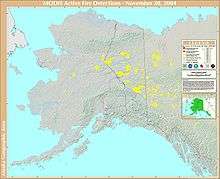
A map of the 2004 fire season's effect on Alaska and the Yukon. | |
| Statistics[1] | |
| Total fires | 701 |
| Total area | 6,600,000 acres (27,000 km2)+ |
| Season | |
|
← 2003
2005 → | |

The 2004 Alaska fire season was the worst on record in terms of area burned by wildfires in the U.S. state of Alaska.[2] Though there were fewer fires than in 1989 when almost 1,000 were recorded, more than 6,600,000 acres (27,000 km2) were burned by 701 fires.[1] The largest of these fires was the Taylor Complex Fire.[3] This fire consumed over 1,700,000 acres (6,900 km2) and was the deemed to be the largest fire in the United States from 1997 to 2007.[3] Out of all 701 fires, 426 fires were started by humans and 215 by lightning.[1]
Causes of the Fires
Beginning in May 2004, the summer was extremely warm and wet in comparison to typical Interior Alaska summer climate. Much of the rain over the summer of 2004 came during thunderstorms, which resulted in record amounts of lightning triggering many of the original fires near Fairbanks, Alaska.[4] Wildfires are prone to develop in areas with frequent lightning strikes.[5] After months of lightning and increased temperatures, an uncharacteristically dry August resulted in fires continuing through September.[4]
Impacts on Climate Change & Landscape
Alaska has a climate that of the boreal zone, more commonly known as the Taiga.[6] The boreal zone, across the globe, makes up more than 25% of global forests, and when wildfires occur it is a top leader in carbon emissions.[6] Approximately 12% of the world's carbon is stored in top layer soil and this part is the first to burn in any wildfire.[7] These emissions have some of the greatest impacts on natural carbon balance, and Alaska gives its fair contribution.[7] Typically Alaskan forest fires make up 41% of the United States total carbon emissions, but more recently with warming conditions and more wildfire occurrences these figures have gone all the way to 89%.[7] Landscape is also changing with regards to wildfires as less canopy is provided after an occurrence, hence soil temperatures may rise and be inhabitable by certain species.[7] When soil temperatures rise permafrost is revealed and begins to melt away.[7] This then leads to Landslides and Erosion.[7]
Impacts on Air Quality
The 2004 fire season of Alaska had large impacts on the air quality and safety of citizens. These impacts were relevant to those specifically living in Fairbanks, Alaska.[1] Deemed by the EPA as a hazardous and unhealthy zone for over 15 days, the city of Fairbanks had about 1,000 micrograms per cubic meter of smoke particulate.[1] To put it into perspective, an area deemed to be unhealthy typically has 65 micrograms of smoke particulate per cubic meter, while an area deemed to be hazardous has anymore than 250 micrograms per cubic meter.[1] Normal levels in Fairbanks, Alaska were around 10 micrograms per cubic meter.[1] The main issue with smoke particulate is not the smoke itself but the matter that is mixed in. Wildfire Smoke is usually made up of acids, chemicals, metals, soil/dust, and pollen/mold spores.[1]
External links
- The U.S. Wildlife and Fisheries outlines potential dangers of the new wildfire fuels that are populating Alaska.
- The University of Alaska Fairbanks shows graphical data pertaining to the amount of land burned and past wildfires in Alaska.
References
- 1 2 3 4 5 6 7 8 "Air Quality - 2004 Wildland Fire Season Summary". dec.alaska.gov. Retrieved 2015-11-24.
- ↑ "2015 wildfire season could be Alaska's worst ever". UPI. Retrieved 2015-11-24.
- 1 2 "Tropical Fire Report Series" (PDF). USFA. Fema.gov.
- 1 2 "2004: The year Alaska's Interior went up in smoke". Alaska Dispatch News. Retrieved 2016-09-15.
- ↑ Nicole Mölders, Gerhard Kramm (June 4, 2006). "Influence of wildfire induced land-cover changes on clouds and precipitation in Interior Alaska — A case study". Atmospheric Research. 84 (2). Retrieved September 15, 2016.
- 1 2 http://resolver.ebscohost.com/openurl?sid=EBSCO%253aedb&genre=article&issn=2169897X&ISBN=&volume=113&issue=D2&date=20080102&spage=n%252fa&pages=&title=Journal+of+Geophysical+Research.+Atmospheres&atitle=Impact+of+the+summer+2004+Alaska+fires+on+top+of+the+atmosphere+clear-sky+radiation+fluxes.&aulast=Pfister%252c+G.+G.&id=DOI%253a10.1029%252f2007JD008797&site=ftf-live
- 1 2 3 4 5 6 Lewis, Sarah (2011). "Using hyperspectral imagery to estimate forest floor consumption from wildfire in boreal forests of Alaska, USA". International Journal of Wildland Fire. CSIRO Publishing.
