A14 motorway (Switzerland)
| Route of the A14 | |||||||||||||||||||||||||||||||||||||||||
 | |||||||||||||||||||||||||||||||||||||||||
| Basic data | |||||||||||||||||||||||||||||||||||||||||
| Total Length: ~20 km (12 mi) | |||||||||||||||||||||||||||||||||||||||||
| Junctions | |||||||||||||||||||||||||||||||||||||||||
| |||||||||||||||||||||||||||||||||||||||||
| Wikimedia Commons has media related to A14 (Switzerland). |
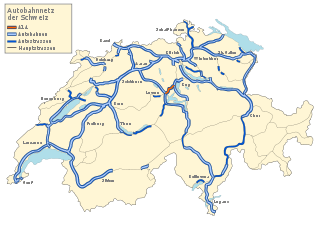
The A14 motorway, an Autobahn in central Switzerland, is a divided highway connecting the A2 with the A4,[1] within the Canton of Lucerne.
The A14 is congruent with the National Road N14 and part of the main traffic artery between the Innerschweitz and the metropolitan area Zurich. It runs mostly along the Reuss (river), which it twice crosses. The second bridge on the Reuss River is the second highest bridge in the Canton of Zug.
Notes
- ↑ "Die Schweitzer Autobahnen", web: Autobahnen.ch
References
- "Die Schweitzer Autobahnen", Autobahnen.ch, 2009, web: Autobahnen.ch (with sub-webpage for A14).
- More sources in "Motorways of Switzerland".
External links
- Photo-series A14 on Autobahnen.ch
- Port expansion project Buchrain-Rontal
- Buchrain Connection/Shuttle Rontal (Canton Lucerne)
Coordinates: 47°07′02″N 8°21′37″E / 47.117343°N 8.360392°E
This article is issued from Wikipedia - version of the 9/30/2016. The text is available under the Creative Commons Attribution/Share Alike but additional terms may apply for the media files.