Aeroflot Flight 3843
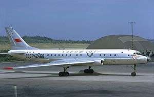
 A Tupolev Tu-104B, similar to the one involved in the accident, is seen here at Arlanda Airport in 1972. | |
| Accident summary | |
|---|---|
| Date | January 13, 1977 |
| Summary | Left engine fire |
| Site | near Almaty Airport, Almaty, Soviet Union |
| Passengers | 82 |
| Crew | 8 |
| Fatalities | 90 (all)[1] |
| Survivors | 0 |
| Aircraft type | Tupolev Tu-104B |
| Operator | Aeroflot |
| Registration | CCCP-42444 |
| Flight origin | Khabarovsk Airport |
| Stopover | Novosibirsk |
| Destination | Almaty Airport |
Aeroflot Flight 3843 crashed on January 13, 1977 after a left engine fire near Almaty Airport.[2]
Aircraft and crew
The accident aircraft was a Tupolev Tu-104B, registered CCCP-42444 to Aeroflot. The plane was delivered to Aeroflot on October 31, 1958 with a capacity of 70 passengers, later altered to hold 85 passengers. At the time of the accident, the aircraft had 27,189 flight hours and 12,819 landings.[3]
The flight crew consisted of:
Dmitry Afanasiev (Афанасьев Дмитрий)- serving as captain
Vladimir Baburin (Бабурин Владимир Иванович)- serving as co-pilot
A. Klimahina (Анатолий Викторович)- serving as navigator
Anatoly Shaforost (Шафорост Анатолий Михайлович)- serving as flight engineer
The cabin crew consisted of flight attendants Maria Faraponova, Alla Hraznova, and Drozdov Korytko.
Accident sequence
Flight 3843 was a flight from Khabarovsk - Novosibirsk - Almaty. The plane departed for the second leg of its flight from Novosibirsk at 17:13. At 17:41 local time the crew communicated with the dispatcher at Almaty Airport and the to ask about weather conditions, were instructed to decrease and approach on the magnetic heading of 230° and head for runway 23. At 107 kilometers from the airport the Tu-104 dropped to a level of 4800 meters; after which the crew asked the dispatcher for an approach that allowed them to continue to decline and approach on a straight line. At 40 kilometers from the airport the plane was at an altitude of 2100 meters, as the crew continued to communicate with the dispatcher. Witnesses noticed the left engine of the plane on fire about 15 kilometers from the airport. With the wing still on fire, the plane then climbed from about 600 feet to 1,000 feet before diving and exploding in a snow-covered field.[4] At 18:12 the crew reported their course, to which the dispatcher responded; although it is worth noting that the plane actually was the on the right of approach 1,600 meters and kept flying at about 1,500 meters right, despite repeated warnings that they were off course. The sky above the airport at the time was clear, although due to the haze visibility was at 1850 meters. The plane hit the ground at an angle of 28°, with a roll at a speed of 150-190 km/h and rotated 200-210° with respect to the runway axis. The fuselage broke in two; the front part of the fuselage sank into the ground 2 meters and. The rear of the fuselage with the tail assembly was pushed back 18 meters and not burned in the fire. Forensic examination showed that during the flight passengers were exposed to carbon monoxide.
Investigation
The accident board found the plane's left engine had been subjected to fire for 10–15 minutes. The fire increased upon slowing down to land due to a decrease in the air flow, damaging the controls. The plane stalled and crashed over three kilometers short of the airport.[4]
Other sources claim the pilots continued to fly around in order to burn up fuel, but the fire reached the fuel tank, causing an explosion.[2]
References
- ↑ "Катастрофа Ту-104А Дальневосточного УГА в районе а/п Алма-Ата". Retrieved 17 November 2016.
- 1 2 Ranter, Harro. "ASN Aircraft accident Tupolev 104A CCCP-42369 Alma-Ata Airport (ALA)". aviation-safety.net. Retrieved 9 August 2016.
- ↑ "✈ russianplanes.net ✈ наша авиация". russianplanes.net. Retrieved 2016-12-02.
- 1 2 "Катастрофа Ту-104А Дальневосточного УГА в районе а/п Алма-Ата (борт CCCP-42369), 13 января 1977 года. // AirDisaster.ru - авиационные происшествия, инциденты и авиакатастрофы в СССР и России - факты, история, статистика". www.airdisaster.ru. Retrieved 2016-12-02.
External links
Coordinates: 43°22′35″N 77°06′10″E / 43.3764°N 77.1028°E