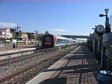
Acre Railway Station
Acre עכו | |
|---|---|
|
Acre Railway Station | |
| Location |
David Remez St., Akko[1] Israel |
| Platforms | 3 |
| Tracks | 3 |
| Construction | |
| Parking | 300 free spaces[1] |
| Bicycle facilities | 4 spaces[1] |
| Disabled access | Yes[1] |
| History | |
| Opened | 1950s |
| Rebuilt | 2002 |
Acre Railway Station (Hebrew: תחנת הרכבת עכו, Taḥanat HaRakevet Ako) is an Israel Railways passenger station serving the city of Acre (Akko) and the surrounding towns and villages.
Location
The station is situated on the North-South coastal line. The Station is located on David Remez Street (Hebrew: רחוב רמז, Reḥov Remez) in the eastern part of the city, across the road from the city market and a short walking distance from the central bus station .
History
The original Acre Railway Station was constructed by the Ottoman Empire in 1912-1913, as part of the extension to Jezreel Valley railway which branched off in Balad al-Sheikh (present-day Nesher). This branch line was destroyed during the First World War, and restored afterwards by the British Mandate for Palestine. During the Second World War, the British extended the railway north of Acre to Beirut and Tripoli; but the old Acre Railway Station was left off the busy Beirut to Cairo line, and it was only served by the suburban services to Haifa and Krayot.
The present-day station was constructed in the early 1950s at the location of the halt on the Beirut-Cairo railway. The location of the original Ottoman two-storey station building is since 1954 occupied by the Acre School for Naval Officers. The building itself was demolished in mid-1960s.
The station underwent a complete reconstruction from the summer of 2001 until the spring of 2002, which included the update to the present passenger station format of Israel Railways, as well as the erection of an island platform (housing platforms 2 and 3), a modern station hall and a tunnel connecting the two platforms. The official inauguration of the new station hall was on 21 May 2002.
Train service to the station was completely suspended on 13 July 2006, the day after the 2006 Israel-Lebanon conflict began, due to the Hezbollah rocket attacks on Acre. It was restored 32 days later, on 14 August, two days after the ceasefire went into effect.
Design
.jpg)
The station consists of a side platform on the west (housing platform 1) and an island platform on the east (housing platforms 2 and 3) as well as two parallel rail tracks running between the side platform and the island platform and a third rail track running east of the island platform. The station hall is located on the west platform and a pedestrian tunnel connects the two platforms beneath the tracks.
Platform 1 is used for northbound trains, platform 2 for southbound trains and platform 3 is used for trains beginning or ending their journey at the station.
Train service
Acre Railway Station is a station on the main North-South coastal line of Israel Railways (Nahariya – Haifa – Tel Aviv – Ben-Gurion International Airport – Beersheba Inter-City Service). The station is situated between Nahariya Railway Station to the north and Kiryat Motzkin Railway Station to the south.
Timetable highlights:
- On weekdays the station is served by 32 southbound and 30 northbound Inter-City trains. First train departs at 01:09 and last train arrives at 01:26.
- On Fridays and holiday eves the station is served by 22 southbound and 20 northbound trains. First train departs at 01:09 and last train arrives at 15:00.
- On Saturdays and holiday the station is served by 6 southbound and 5 northbound trains. First train departs at 18:53 and last train arrives at 23:07.
Public transport connections
Acre Railway Station is located a short walking distance from Acre's central bus station, thus passenger can reach the station from almost every part of the region. A number of Inter-City and local buses stop just in front of the station, providing even better connection to the railway station.
Sherut Taxis (share taxis) stop on the street, just outside the station.
Facilities
References
External links
| Preceding station | Israel Railways | Following station | ||
|---|---|---|---|---|
| Towards: Nahariya Nahariya |
Nahariya – Haifa – Tel Aviv – Ben-Gurion Airport – Modi'in Inter-City Service |
Towards: Modi'in Central Kiryat Motzkin | ||
| Towards: Nahariya Nahariya |
Nahariya – Haifa – Tel Aviv – Be'er Sheva Inter-City Service |
Towards: Be'er Sheva Center Kiryat Motzkin | ||
| Towards: Nahariya Nahariya |
Nahariya – Kiryat Motzkin - Haifa Suburban Service |
Towards: Hof HaCarmel Kiryat Motzkin |
Coordinates: 32°55′41″N 35°04′58″E / 32.928148°N 35.082822°E
