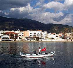
Altınoluk
| Altınoluk | |
|---|---|
| Town | |
|
Altınoluk | |
 Altınoluk | |
| Coordinates: 39°34′56″N 26°44′22″E / 39.58234°N 26.73935°ECoordinates: 39°34′56″N 26°44′22″E / 39.58234°N 26.73935°E | |
| Country |
|
| Region | Aegean |
| Province | Balıkesir |
| District | Edremit |
| Government | |
| • Mayor | Hasan Özpolat (CHP) |
| Population (2009) | |
| • Total | 13,800 |
| Time zone | EET (UTC+2) |
| • Summer (DST) | EEST (UTC+3) |
| Postal code | 10870 |
| Area code(s) | 266 |
| Licence plate | 10 |
| Website | www.altınoluk |
Altınoluk, formerly Papazlık, is a town and summer resort in the Edremit district of Balıkesir Province in western Turkey. It is located 25 km (16 mi) west of Edremit, at the northern coast of Edremit Bay and on Mount Kazdağı hills.
The ancient city Antandrus, Kazdağı National Park and Şahindere Canyon are visitor attractions around Altınoluk.
External links
- Altınoluk Municipality website (Turkish)
- Altınoluk Municipality profile at YerelNet.org.tr (Turkish)
- Altınoluk Guide (Turkish)
This article is issued from Wikipedia - version of the 2/9/2015. The text is available under the Creative Commons Attribution/Share Alike but additional terms may apply for the media files.
