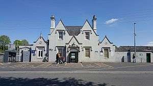
Athy railway station
 Athy Railway Station Photo: Andrew McCarthy | |||||||||||||||||||||
| Location |
Athy Republic of Ireland | ||||||||||||||||||||
| Coordinates | 52°59′33″N 6°58′36″W / 52.9925°N 6.9768°WCoordinates: 52°59′33″N 6°58′36″W / 52.9925°N 6.9768°W | ||||||||||||||||||||
| Owned by | Iarnród Éireann | ||||||||||||||||||||
| Operated by | Iarnród Éireann | ||||||||||||||||||||
| Platforms | 2 | ||||||||||||||||||||
| Construction | |||||||||||||||||||||
| Structure type | At-grade | ||||||||||||||||||||
| Other information | |||||||||||||||||||||
| Station code | ATHY | ||||||||||||||||||||
| Fare zone | F | ||||||||||||||||||||
| Key dates | |||||||||||||||||||||
| 4 August 1856 | Station opens | ||||||||||||||||||||
| 6 September 1976 | Station closes to goods | ||||||||||||||||||||
| Unknown date | Station closes to passengers | ||||||||||||||||||||
| 14 February 1985 | Station reopens | ||||||||||||||||||||
| Services | |||||||||||||||||||||
| |||||||||||||||||||||
Athy railway station serves the town of Athy in County Kildare.
It is a station on the Dublin to Waterford intercity route.[1]
Description
The single track north and south of the station splits to provide two platforms. Platform 1, next to the station building, car park and pedestrian entrance, is used where possible for passenger services. only when two trains are in the station simultaneously is Platform 2 used. At the southern end of the station is a branch to the Tegral factory begins, but this is no longer used.
Due to the rapid growth of Athy itself, this station has seen considerable growth in passenger numbers. In 2004 the mechanical signalling system was replaced. In 2007 the platforms were extended to accommodate longer trains, a development which included the demolition of the signal box.[2] In July 2008, planning permission was granted for the refurbishment of the partially derelict station building itself.[3]
History
The station opened on 4 August 1846.Opened by the Great Southern and Western Railway, the station was amalgamated into the Great Southern Railways.
The line was nationalised, passing to the Córas Iompair Éireann with the Transport Act 1944 which took effect from 1 January 1945 and closed for goods traffic on 6 September 1976.[4]
It passed on to Iarnród Éireann in 1986.
See also
References
- Butt, R. V. J. (1995). The Directory of Railway Stations: details every public and private passenger station, halt, platform and stopping place, past and present (1st ed.). Sparkford: Patrick Stephens Ltd. ISBN 1-8526-0508-1. OCLC 60251199.
- Jowett, Alan (2000). Jowett's Nationalised Railway Atlas (1st ed.). Penryn, Cornwall: Atlantic Transport Publishers. ISBN 0-9068-9999-0. OCLC 228266687.
- Jowett, Alan (March 1989). Jowett's Railway Atlas of Great Britain and Ireland: From Pre-Grouping to the Present Day (1st ed.). Sparkford: Patrick Stephens Ltd. ISBN 1-8526-0086-1. OCLC 22311137.
- ↑ "Timetables". Irish Rail.
- ↑ "Planning Application 06/300025". Kildare County Council Planning Applications. Retrieved 28 October 2016.
- ↑ "Planning Application 07/300070". Kildare County Council Planning Applications. Retrieved 28 October 2016.
- ↑ "Athy station" (PDF). Railscot - Irish Railways. Archived (PDF) from the original on 26 September 2007. Retrieved 4 September 2007.