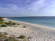
Bahia de las Aguilas

Literally "Eagles Bay", Bahia de las Aguilas is an 8 km long beach along the southwestern coast of the Dominican Republic near the southernmost part of the border with Haiti. The bay is part of the Jaragua National Park, and it is considered by many Dominicans ( and visitors as well) as one of the most beautiful beaches in the world. The bay is a protected area as is the surrounding park, hence there is an abundance of seal life just feet off the beach within its waters.
The thing that visitors like the most about this beach, is that is totally isolated. 323 km from Santo Domingo and approximately 25 km from Pedernales (the nearest town), this beach is a true oasis in the middle of the deserted steppe of the park. Departing from Pedernales, one gets to a small village called "La Cueva" (literally "The Cave") named so because of the numerous caves surrounding the village, where up until 2007, used to be occupied by local fishermen. La Cueva is located on a tip of land called Cabo Rojo ( Red Cape/Point). Here visitors can hire one of the local villagers to take them to the beach bordering the coast on a small motorboat, by foot or with an all-wheel-drive vehicle and a good driver going through the park itself (either way it is a 10- to 15-minute ride; 45 on foot).
Currently there is a legal process in course as the territories on which Bahia de las Aguilas is located were supposed to be "acquired" by persons with political connections. This has generated a lot of reactions from civil society as these acquisitions have been attributed to corruption practices.
External links
| Wikivoyage has a travel guide for Bahia de las Aguilas. |
http://www.diariolibre.com/cronologia/ver/meta/bahia-de-las-aguilas
- http://www.listindiario.com/app/article.aspx?id=48661
- http://www.grupojaragua.org.do/pnj.html#Comunidades%20Aleda%C3%B1as
Coordinates: 17°51′44″N 71°38′44″W / 17.86214°N 71.64557°W