Baljvine
| Baljvine | |
|---|---|
| Village | |
|
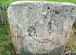
Stećak in Baljvine | |
| Country | Bosnia and Herzegovina |
| Entity | Republika Srpska |
| Municipality | Mrkonjić Grad |
| Lowest elevation | 495 m (1,624 ft) |
| Population (1991 (2013)) | |
| • Total | 1,140 (437) |
Baljvine is a village located in the municipality of Mrkonjić Grad in Bosnia and Herzegovina. It is in the administrative entity Republic of Srpska. According to census estimates in 1991, the village population was 1,140. The population decreased from 973 to 437 people in 2013.
Geography
Lower Baljvine is located on a plateau above the Vrbas river at an altitude of approximately 495 m. Upper Baljvine is at 566 m. The edge of the village lies on the southeastern slope of Čemernica Mountain. Local roads connect Baljvine to the main roads M-16 and E-661.[1][2][3]
History
Baljvine dates back to the 14th century, evidenced by the medieval stećak tombstones in the hamlet of Kocelji. In May 2003, the village was declared a national monument of culture in Bosnia and Herzegovina.[4] The Balkanska mosque is another ancient structure in Baljvine. It was the only mosque left intact in the Banja Luka region during the War in Bosnia (1992–1995).
During World War II, Baljvine was a stop on the supply line for Yugoslav Partisan units operating in Central Bosnia. The route passed through the Vrhovine highlands from Prnjavor via Čečava, Klupe (Borja), Maslovare and Skender Vakuf to Baljvine and from there to the entire Bosanska Krajina region. This route was used by many groups, including the "people's government" and military delegations. It was especially useful for units of the 11th Krajina Division of the Partisans, who used it as a message stop. It was used for transport by packhorse of food and livestock, donated by the people of the župa (district) to aid partisan units and others in Bosanska Krajina. Military supplies for the Partisans and their supporters also flowed in the opposite direction, from Mrkonjic Grad across the Vrbas. The route was used by the League of Communists of Yugoslavia, students on military-political and medical courses, and couriers who delivered reports and messages. The Chetniks had links to the Ustashe and to the Germans who were permitted to operate a radio station and intelligence points in Chetnik territory: all this posed a constant danger to users of this route and to supplies bound for the Divisional hospital.[5][6][7]
Population
| Baljvine | ||||||
|---|---|---|---|---|---|---|
| Census Year | 1991 | 1981 | 1971 | |||
| Muslims | 699 (61.31%) | 654 (53.34%) | 593 (49.41%) | |||
| Serbs | 438 (38.42%) | 565 (46.08%) | 601 (50.08%) | |||
| Croats | 0 | 0 | 2 (0.16%) | |||
| Yugoslavs | 1 (0.08%) | 7 (0.57%) | 2 (0.16%) | |||
| Others and unknown | 2 (0.17%) | 0 | 2 (0.16%) | |||
| Total | 1,140 | 1,226 | 1,200 | |||
References
- ↑ Vojnogeografski institut, Izd. (1955): Jajce (List karte 1:100.000, Izohipse na 20 m). Vojnogeografski institut, Beograd.
- ↑ Spahić M. et al. (2000): Bosna i Hercegovina (1:250.000). Izdavačko preduzeće "Sejtarija", Sarajevo.
- ↑ Mučibabić B., Ur. (1998): Geografski atlas Bosne i Hercegovine. Geodetski zavod BiH, Sarajevo, ISBN 9958-766-00-0.
- ↑ http://www.aneks8komisija.com.ba/main.php?id_struct=6&lang=1&action=view&id=833. Retrieved 20 July 2015. Missing or empty
|title=(help) - ↑ Samardžija S. (1983): Četrnaesta srednjobosanska NOU brigada. Skupština opštine Prnjavor, Banja Luka.
- ↑ Petrić N., Ur. (1985): Opštine Kotor-Varoš i Skender-Vakuf u NOB-u 1941–1945. Radnički univerzitet "Đuro Pucar Stari", Kotor Varoš.
- ↑ Đondović R., Ur. (1989): Sanitetska služba u narodnooslobodilačkom ratu Jugoslavije 1941–1945, Knj. 2: Nastanak i razvoj sanitetske službe u oružanim snagama narodnooslobodilačkog pokreta u Bosni i Hercegovini, Crnoj Gori, Hrvatskoj i Makedoniji; Biblioteka Ratna prošlost naroda i narodnosti Jugoslavije, knj. 361. Monografija Jedinica NOV i PO Jugoslavije, Knj. 150). Vojnoizdavački i novinski centar, Sanitetska uprava SSNO, Beograd.
See also
Coordinates: 44°28′48″N 17°11′52″E / 44.4800°N 17.1978°E
