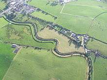
Ballymagorry

Ballymagorry or Ballymagory (Irish: Baile Mhic Gofraidh (MacGorry's townland)[1]) is a small village and townland in County Tyrone, Northern Ireland. It is west of Artigarvan and 5 kilometres (3.1 mi) north of Strabane. In the 2001 Census it had a population of 565. It lies within the Strabane District Council area and lies on the River Glenmornan.[2]
History
It has been a settlement since Plantation times, being founded in the early 17th century by Scotsman Sir George Hamilton of Greenlaw who died around 1654, and whose brother was James Hamilton, 1st Earl of Abercorn. Within two generations his lands had been consolidated into the Manor of Cloghogall within the extensive Abercorn estate. The village is known as Bellymagarry in Ulster-Scots.
Transport
The area was once served by rail with Ballymagorry railway station run by the County Donegal Railway on the section from Strabane (CDR) railway station to Londonderry Victoria Road in Derry line. Ballymagorry station opened on 7 August 1900 but was shut on 1 January 1955.[3] The village lies on the main A5 trunk road between Strabane and 'Derry.
Demography
19th century population
The population of the village decreased during the 19th century:[4][5]
| Year | 1841 | 1851 | 1861 | 1871 | 1881 | 1891 |
|---|---|---|---|---|---|---|
| Population | 213 | 169 | 181 | 155 | 127 | 106 |
| Houses | 46 | 39 | 39 | 37 | 31 | 25 |
21st century population
Ballymagorry is classified as a small village.[6] On Census day (29 April 2001) there were 565 people living in Ballymagorry. Of these:
- 25.3% were aged under 16 years and 15.2% were aged 60 and over
- 50.4% of the population were male and 49.6% were female
- 43.7% were from a Catholic background and 54.0% were from a Protestant background
- 4.8% of people aged 16–74 were unemployed
Ballymagorry Townland
The townland is situated in the historic barony of Strabane Lower and the civil parish of Leckpatrick and covers an area of 289 acres.[7]
The population of the townland increased slightly during the 19th century:[8][9]
| Year | 1841 | 1851 | 1861 | 1871 | 1881 | 1891 |
|---|---|---|---|---|---|---|
| Population | 65 | 46 | 71 | 80 | 118 | 66 |
| Houses | 12 | 11 | 13 | 14 | 21 | 15 |
See also
References
| Wikimedia Commons has media related to Ballymagorry. |
- ↑ "Ballymagorry". Place Names NI. Retrieved 18 March 2013.
- ↑ "BBC Domesday Reloaded".
- ↑ "Ballymagorry station" (PDF). Railscot - Irish Railways. Archived (PDF) from the original on 26 September 2007. Retrieved 2007-09-11.
- ↑ "Census of Ireland 1851". Enhanced Parliamentary Papers on Ireland. Retrieved 22 March 2013.
- ↑ "Census of Ireland 1891". Enhanced Parliamentary Papers on Ireland. Retrieved 22 March 2013.
- ↑ NI Statistics and Research Agency (NISRA)
- ↑ "Townlands of County Tyrone". IreAtlas Townland Database. Retrieved 28 December 2012.
- ↑ "Census of Ireland 1851". Enhanced Parliamentary Papers on Ireland. Retrieved 28 December 2012.
- ↑ "Census of Ireland 1891". Enhanced Parliamentary Papers on Ireland. Retrieved 28 December 2012.
External links
Coordinates: 54°51′N 7°26′W / 54.850°N 7.433°W