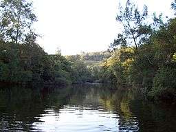
Barrington River (New South Wales)
Barrington River, a perennial river of the Manning River catchment, is located in the Upper Hunter district of New South Wales, Australia.
Course and features
Barrington River rises below Carey's Peak, within Barrington Volcano, on the eastern slopes of the Mt Royal Range, within the Great Dividing Range, and flows generally east, joined by five tributaries including the Kerripit, Cobark, and Moppy rivers, before reaching its confluence with the Gloucester River, near Gloucester. The river descends 1,370 metres (4,490 ft) over its 93 kilometres (58 mi) course.[2]
The river was named in honour of Lord Barrington.[1]
The river is popular with kayakers and canoers due to its sections of white water and attractive scenery,[3] and flows through the Barrington Tops National Park.
See also
References
External links
|
|---|
|
| |
|---|
|
- Backwater
- Bakers
- Beean Beean
- Belbora
- Ben Halls
- Berrico
- Buggs
- Burrell
- Callaghans Swamp
- Clear Hill
- Dog Trap
- Mackays
- Mograni
- Myall
- Oaky
- Orham
- Pipeclay Gully
- Sandy
- Schofields
- Scotts
- Tindag
- Titaatee
- Tomalla
- Tuggolo
- Waukivory
- Wild Cattle
- Williams
|
|
|
| |
|---|
|
- Alderley
- Black Bullock
- Blue Gum
- Boggy
- Boomerang
- Booral
- Bungwahl
- Bunyah
- Candoormakh
- Carrington
- Carrs
- Caseys
- Deep
- Firefly
- Horse
- Kelly
- Khoribakh
- Kundle
- Kyle
- Lamans
- Lawlers
- Lewis
- Limeburners
- Little Branch
- Little Myall
- Martins
- Mill
- Monkey Jacket
- Oakey
- Pipers
- Scotters
- Sharpers
- Snapes
- Spring
- Sugar
- Talawahl
- Teatree
- Terreel
- Waterloo
- Whispering Gully
|
|
|
|
|
|
|
|---|
|
| Towns, suburbs and localities |
- Alison
- Allynbrook
- Anleys Creek
- Bandon Grove
- Barrington Tops
- Bendolba
- Bingleburra
- Black Camp
- Bonnington
- Bonnington Park
- Brookfield
- Brownmore
- Cairnsmore
- Cambra
- Camyr Allyn
- Cangon
- Carrabolla
- Cawarra
- Chads Creek
- Chichester
- Cintra
- Clarence Town
- Clarence Town West
- Clay Hill
- Colstoun
- Cooreei
- Coulston
- Crooks Park
- Dingadee
- Douribang
- Dungog
- Dusodie
- East Gresford
- Eccleston
- Elms Hall
- Fishers Hill
- Flat Tops
- Fosterton
- Glen Martin
- Glen Oak
- Glen William
- Gresford
- Halton
- Hanleys Creek
- Hilldale
- Kenilworth
- Kilbride
- Lennoxton
- Lewinsbrook
- Lostock
- Lyndhurst Vale
- Main Creek
- Marshdale
- Martins Creek
- Masseys Creek
- Maxwells Creek
- Melbee
- Mill Hills
- Mount Rivers
- Munni
- Paterson
- Pine Brush
- Quartpot
- Raglan
- Salisbury
- Sugarloaf
- Summerhill
- Tabbil Creek
- Tillegra
- Tillimby
- Torryburn
- Trevallyn
- Tunnibuc
- Underbank
- Upper Allyn
- Upper Chichester
- Vacy
- Wallaringa
- Wallarobba
- Wangat
- Webbers Creek
- Welshmans Creek
- Wirragulla
- Woerden
|
|---|
|
| Rivers and other waterways | |
|---|
|
| Other places and points of interest | |
|---|
|
|---|
|
|
|
|
|
| Entertainment, sport and culture |
|---|
| |
|
|
|
|
| Historical |
|---|
| | Air transport | |
|---|
| | Defence | |
|---|
| | Education | |
|---|
| | General | |
|---|
| | Industry | |
|---|
| | Maritime | |
|---|
| | Natural disasters | |
|---|
| | People | |
|---|
| | Rail | | General | |
|---|
| | Railway lines | |
|---|
| | Railway stations | |
|---|
| | Trams | |
|---|
|
|---|
| | Wine making | |
|---|
| | World War II | |
|---|
|
|
|
| Infrastructure |
|---|
| | Transport | | Road | |
|---|
| | Railway lines | |
|---|
| | Railway stations | |
|---|
| | Bus | |
|---|
| | Air | |
|---|
|
|---|
| | Utilities | | Electricity generation | |
|---|
| | Water supply | |
|---|
|
|---|
|
|
|
|
|
|
Coordinates: 31°58′S 151°44′E / 31.967°S 151.733°E / -31.967; 151.733
