Battle Ground Historic District
|
Battle Ground Historic District | |
|
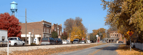
Battle Ground, Indiana, October 2006 | |
   | |
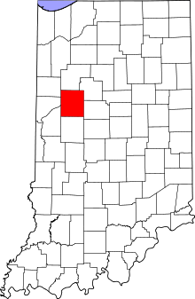
| Location | Roughly bounded by Burnett Creek, Sherman Dr. and an open ridge on the SE, Battle Ground, Indiana |
|---|---|
| Coordinates | 40°30′35″N 86°50′21″W / 40.50972°N 86.83917°WCoordinates: 40°30′35″N 86°50′21″W / 40.50972°N 86.83917°W |
| Area | 81 acres (33 ha) |
| Built | 1811 |
| Architectural style | Late Victorian, Colonial, Dutch Colonial |
| NRHP Reference # | 85001639[1] |
| Added to NRHP | July 23, 1985 |
Battle Ground Historic District is a national historic district located at Battle Ground, Tippecanoe County, Indiana. The district encompasses 129 contributing buildings in the central business district of Battle Ground, including the site of the Battle of Tippecanoe. It developed between about 1811 and 1930 and includes representative examples of Queen Anne, Colonial Revival, and Bungalow / American Craftsman style architecture. Notable contributing resources include the Soldier's Memorial (1908), Carpenter Hall / Service Center (c. 1884, 1926), Chapel (c. 1825), Winans House (c. 1863), Battle Ground United Methodist Church (1920), Masonic Lodge (c. 1918), Odd Fellow Lodge (1899), and Knights of Pythias Lodge (1899).[2]
It was listed on the National Register of Historic Places in 1985.[1]
References
- 1 2 National Park Service (2010-07-09). "National Register Information System". National Register of Historic Places. National Park Service.
- ↑ "Indiana State Historic Architectural and Archaeological Research Database (SHAARD)" (Searchable database). Department of Natural Resources, Division of Historic Preservation and Archaeology. Retrieved 2016-07-01. Note: This includes Daniel J. Fogerty (September 1984). "National Register of Historic Places Inventory Nomination Form: Battle Ground Historic District" (PDF). Retrieved 2016-07-01., Site map, and Accompanying photographs


