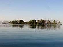
Black River Island

Black River Island is an island in Lake Huron. It is part of a series of shoals around the mouth of Black River and is 3⁄4 mile (1.21 km) NE of it.[1] The island is included within the unincorporated community of Black River in Alcona Township.
The uninhabited rocky island is about 1,000 feet (305 m) long.[1] Its area is less than one acre[2] and varies with lake levels.[3]
The shoals in the area are a boating hazard.[4][5] The schooner William H. Rounds, carrying a load of coal, ran aground on the island in May 1905 and was destroyed.[6][7] Further south the tugboat Loretta, carrying a load of chain, broke its propeller and caught fire in October 1896.[8] The Ishpeming, a schooner carrying a load of coal, ran aground in November 1903. It was scrapped and abandoned.[9] These are marked by buoys.
In the past, owners of the island have shown interest in selling it to wildlife organizations.[3] The island is approximately 7 miles south of Scarecrow Island which is part of the Michigan Islands National Wildlife Refuge.
References
- 1 2 Black River Navigation Facilities Construction, Alcona County: Environmental Impact Statement. U. S. Army Engineer District, Detroit, Michigan. 1970-10-09. p. 3. Retrieved 22 June 2016.
- ↑ Shoreland Management For Lake Huron and Northeast Michigan. Northeast Michigan Regional Planning and Development Commission. April 1976.
- 1 2 Annual Narrative Report. Shiawassee National Wildlife Refuge. 1996. p. 41. Retrieved 22 June 2016.
- ↑ "Negwegon - Black River - Ossineke Blueway". US 23 Heritage Route. Northeast Michigan Council of Governments. Retrieved 22 June 2016.
- ↑ Sailing directions for Lake Huron, straits of Mackinac, St. Clair and Detroit rivers, and Lake St. Clair. United States Hydrographic Office. 1895. ISBN 978-1236004086. Retrieved 22 June 2016.
- ↑ "More on the Recor and the Rounds". Alcona County Genealogical Society. Retrieved 22 June 2016.
- ↑ "William H. Rounds". Thunder Bay National Marine Sanctuary. National Ocean Service. Retrieved 24 June 2016.
- ↑ "Loretta". Thunder Bay National Marine Sanctuary. National Ocean Service. Retrieved 24 June 2016.
- ↑ "Ishpeming". Thunder Bay National Marine Sanctuary. National Ocean Service. Retrieved 24 June 2016.
Coordinates: 44°49′55″N 83°17′04″W / 44.83194°N 83.28444°W