Blankenese Low Lighthouse
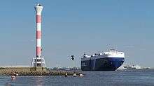
 Lighthouse with Orion Leader NYK Line Vehicle Carrier | |
| Location | Blankenese, Hamburg |
|---|---|
| Coordinates | 53°33′27.80″N 09°47′44.66″E / 53.5577222°N 9.7957389°ECoordinates: 53°33′27.80″N 09°47′44.66″E / 53.5577222°N 9.7957389°E |
| Year first constructed | 1984 |
| Year first lit | since 29. November 1984 |
| Construction | Reinforced concrete |
| Tower shape | Cylinder Tower, 2 Signals lamps |
| Markings / pattern | White and Red |
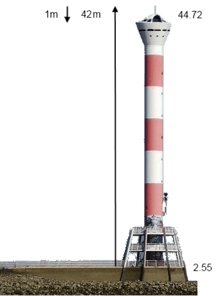
| Height | 42 metres (138 ft) |
| Focal height | 41 metres (135 ft), height of light |
| Original lens | electric |
| Intensity | 13 Mcd |
| Range | 8,410 metres (4.54 nmi) |
| Characteristic | Glt. W 4s (Equal Light, White, 4 Seconds) |
| Admiralty number | B 1568.7 |
The Blankenese Low Lighthouse forms since November 29, 1984 together with the Lighthouse High Blankenese a range of lights for ships sailing upriver on the Elbe, with 8,410 meters, the longest at the Unterelbe, at the Hamburg district Blankenese.[1] Their plan accompanied the early 1980s of large protests by the population, even fought in court. As "light asparagus" on the "rocket launcher", it was quoted in a book "Fire at German coasts", the Hamburg newspapers of that era and the "lighthouse as a thorn in the flesh of Blankeneser". It has Love lock.
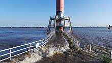
The 42 meter high, red and white striped concrete tower with white steel lantern house was built in 1984. The column has 12 Portholes to river and 2 behind and the lantern house has another 6. It stands in the Elbe, approximately 1,340 meters from the rear light, and is on a circa 30 meters long Platform, stack reached. On the base of the Tower has a 2 level staircase Deck, which is 5 m high, 2.5 m each floor in a trapezoid Steel frame form section with an Octagon plant design. [2] The tower itself works as a sun clock pointer to the people seating at its shadow side concrete banks around a tree. Inside it has a helix staircase driving to the top. There is not a seating place at the top of the Platform, only at the bottom, which by high Tide sometimes get washed. At the third floor, it has a door with a plate showing the function of the Structure. However due Graffiti this is covered to see. The concrete foundation was established using a caisson with an average of 5 m inside water different Tide between maximum high and lowest one. It weighs over 700 tons and reaches 10 meters below the water surface. The 11 ton lantern house was assembled with the help of a floating crane. The lighthouse is remotely controlled by the Seemanshöft Pilot Centre and belongs to the Hamburg Port Authority.


Weblinks (German)
| Wikimedia Commons has media related to Blankenese Unterfeuer. |
- Daten und Bilder bei leuchtturm-atlas.de
- Daten bei leuchtturm-web.de
- Beschreibung auf leuchttuerme.net
- Bilder und Beschreibung
References
- ↑ http://skyscraperpage.com/cities/?buildingID=99475 | Description of the Lighthouse Structure
- ↑ http://skyscraperpage.com/diagrams/?searchID=68977319 | Structure
Gallery
-
Plate Description
-
Companies Involved
-
Location
-
Water Level (m) 44.72 NN (Niedrig-Niedrg) Low-Low Tide
-
Water Level (m) 2.55 NN
-
Detail
-
Deck Rail
-
Door Graffiti
-
Lighthouse Stairs
-
Lighthouse Ground Level