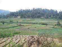
Bogahakumbura
| Bogahakumbura බෝගහකුඹුර | |
|---|---|
 Bogahakumbura | |
| Coordinates: 6°51′43″N 80°52′35″E / 6.86194°N 80.87639°E | |
| Province | Uva Province |
| District | Badulla |
| Divisional Secretariat | Welimada |
| Area | |
| • Land | 9 km2 (3 sq mi) |
| • Water | .5 km2 (0.2 sq mi) |
| Population | |
| • Total | 1,500 |
| Time zone | Sri Lanka Standard Time Zone (UTC+5:30) |
| Postal Code | 90354 |
Bogahakumbura (බෝගහකුඹුර in Sinhala language)is a rural town in Sri Lanka. It is located in Badulla District of Uva Province, Sri Lanka. Majority of people in the area are involved with vegetable cultivation.[1]
This town is located between Haputale - Keppetipola main road. Haputale (17 km), Welimada (12 km), Bandarawela (18 km), Nuwaraeliya (26 km) and Diyatalawa(12 km) are closest major towns from Bogahakumbura. Boralanda (6 km), Keppetipola (6 km/7 km) are the closest minor towns for bogahakumbura.[2][3] The Grama Niladhari Division of the Bogahakumbura is 51.[4]

Bogahakumbura town is rapidly growing town in Welimada Area. Most closer reason for that is large number of vegetable amount cultivated daily and bidding in the town. About 50 lorries are come from Dambulla, Keppetipola, Bandarawela, Marata, Hambantota, Wellawaya, Ampara and some other places to buy vegetables. About 25 vegetable bidding centers are available in the town. Alawathugoda, Wangiyakumbura, Kandepuhulpola, Pahala Ambewela, Gatalagamuwa, Kirindi Ela, Hewanakumbura, Kalabululanda and Alugolla people visit this town daily. Government schools, Hospital, Temples, Shops, Banks and Post office are available.
Government Institutions
There are several government institutes are available in Bogahakumbura city.
- Bogahakumbura - Base Hospital [5]
- Sub Post Office (90354)
- Bank of Ceylon
- Peoples' Bank
- Regional Development Bank
- Govijana Seva Center
Places
- Udakirinda Vipassana Bhawana Center [6] is popular meditation center closed to Bogahakumbura town. There are about 4 kilometers from the town.
- Udamala Mountain [7] is popular peak between Bogahakumbura and Pattipola village. There are about 8 kilometers from the town.
- Diyawatanalla Waterfall [8] is beautiful waterfal closed to Bogahakumbura town. About 2Km to the waterfall from Bogahakumbura. This waterfall is at Alawathugoda village.
Tourist Attractions
There are several tourist attractions closed to Bogahakumbura town.
- Adisham Bungalow - Haputale (15Km)
- Ohiya (17 km)
- Horton Plains (25 km)
- Nuwaraeliya (26 km)
- Hakgala Botanical Garden (22 km)
- Bomburu Ella Waterfalls (28 km)
- Fox Hill Track - Diyathalawa (18 km)
- Boralanda Farm (6 km)
- Streepura Caves (25 km)
- Ambewela (24 km)
- Diwrumwela Temple (10 km)
- 18th Railway Tunnel (5 km)
- Railway Summit Level (6 km)
Famous Persons
Few persons started their journey from Bogahakumbura.
- Mrs. Hema Rathnayake (Former Minister of Women affairs in 1994 -2000, Member of Uva provincial council from 2004 to present)
- Priyantha Rathnayake (Actor)
- N.M. Jayathilake (Politician)
Postal Services
- Bogahakumbura Sub Post Office [9]
- Postal code 90354
- Telephone (0094)(057) 228 0350
External links
- Bogahakumbura Maha Vidyalaya [10]
- Temple of Alawathugoda (Sri Wijayawardanaramaya) [11]
- Maha Sanga [12]
- Bogahakumbura Facebook Page [13]
- Jummah Mosque [14]
- BD/Bogahakumbura Muslim Vidyalaya[15][16]
See also
References
- ↑ Growing Soils
- ↑ Post Harvest
- ↑ potatoes
- ↑ Grama Niladhari Divisions
- ↑ Hospitals Archived March 12, 2008, at the Wayback Machine.
- ↑ https://www.google.lk/maps/place/Udakirinda+Wipassana+Meditation+Center/@6.8657562,80.8527149,17z/data=!3m1!4b1!4m2!3m1!1s0x3ae479ad5395a7db:0x788cf970fe261f30 [Bhawana Center]
- ↑ http://www.sarisara.com/udamala/main.php [Udamala]
- ↑ http://www.alawathugoda.com/beauty/diyawatanalla [Diyawatanalla Falls]
- ↑ Postal Codes Archived August 4, 2009, at the Wayback Machine.
- ↑ Bogahakumbura Maha Vidyalaya
- ↑ Temple of Alawathugoda Bogahakumbura
- ↑ Maha Sanga
- ↑
- ↑ Jummah Mosque
- ↑ rightmenue=1&sid=4&orderby=fldSTITLE&title=Sri%20Lanka%20Muslim%20Schools%20in%20Badulla%20District Bogahakumbura Muslim Vidyalaya Archived April 4, 2009, at the Wayback Machine.
- ↑
Coordinates: 6°51′43″N 80°52′35″E / 6.86194°N 80.87639°E