Buenavista del Norte
| Buenavista del Norte | ||
|---|---|---|
| Municipality and town | ||
|
Masca | ||
| ||
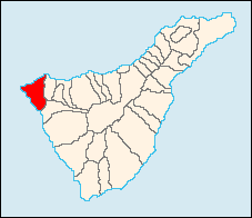
 Municipal location in Tenerife | ||
 Buenavista del Norte Location of the town in Tenerife | ||
| Coordinates: 28°22′12″N 16°51′0″W / 28.37000°N 16.85000°WCoordinates: 28°22′12″N 16°51′0″W / 28.37000°N 16.85000°W | ||
| Country |
| |
| Autonomous Region | Canary Islands | |
| Province | Santa Cruz de Tenerife | |
| Island | Tenerife | |
| Area | ||
| • Total | 26.03 sq mi (67.42 km2) | |
| Population (2013)[1] | ||
| • Total | 4,961 | |
| • Density | 206/sq mi (79.4/km2) | |
| Time zone | GMT (UTC+0) | |
| Post Code | 38640 | |
| Website | www.buenavistadelnorte.com | |
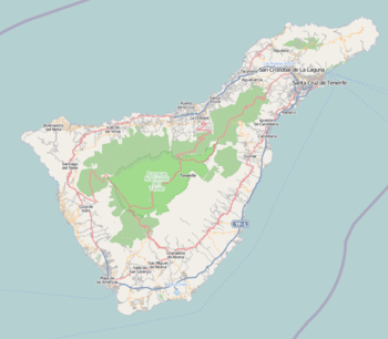
Buenavista del Norte is a municipality and town on the north coast of Tenerife. It is located on the TF42 Road, about 75 km west of the capital Santa Cruz de Tenerife, and 65km from Tenerife North Airport.
The towns streets hide sober architecture of clearly Andalusian extraction. Nevertheless, apart from the influence of the Conquistadors, there is a mixture of the traditions of Portuguese inhabitants and of Guanches, as the pre-Hispanic natives were known, which have helped to make up the particular charm of this district. The people have, due to the scarcity of resources, been characterised by an unquenchable spirit of conservation, which has kept alive traditions such as craftwork in bone, wood, cane and straw from the local forests of the region.[2]
Climate
Buenavista del Norte has a Mediterranean climate, mild to warm year round, with rain falling from October to March. Its exposed northwesterly location allows it to trap most of the moisture condensed by the mountains of Tenerife, so that it receives over three times more rainfall than Santa Cruz de Tenerife.
| Climate data for Buenavista del Norte | |||||||||||||
|---|---|---|---|---|---|---|---|---|---|---|---|---|---|
| Month | Jan | Feb | Mar | Apr | May | Jun | Jul | Aug | Sep | Oct | Nov | Dec | Year |
| Average high °C (°F) | 17.1 (62.8) |
17.0 (62.6) |
17.2 (63) |
17.3 (63.1) |
18.6 (65.5) |
19.9 (67.8) |
22.3 (72.1) |
23.1 (73.6) |
22.6 (72.7) |
21.5 (70.7) |
19.0 (66.2) |
17.3 (63.1) |
19.4 (66.9) |
| Average low °C (°F) | 12.1 (53.8) |
11.5 (52.7) |
11.8 (53.2) |
11.9 (53.4) |
13.1 (55.6) |
14.4 (57.9) |
16.7 (62.1) |
17.7 (63.9) |
17.2 (63) |
16.5 (61.7) |
14.9 (58.8) |
13.0 (55.4) |
14.2 (57.6) |
| Average precipitation mm (inches) | 167 (6.57) |
95 (3.74) |
70 (2.76) |
18 (0.71) |
12 (0.47) |
9 (0.35) |
1 (0.04) |
3 (0.12) |
4 (0.16) |
90 (3.54) |
207 (8.15) |
122 (4.8) |
798 (31.42) |
| Source: Sistema de Clasificación Bioclimática Mundial [3] | |||||||||||||
 |
Atlantic Ocean |  | ||
| Atlantic Ocean | |
Los Silos | ||
| ||||
| | ||||
| Santiago del Teide |
References
- ↑ Instituto Canario de Estadística
- ↑ webtenerife.co.uk
- ↑ "Sistema de Clasificación Bioclimática Mundial. Buenavista, Tenerife".

