Cabo da Praia
| Cabo da Praia | |
| Civil Parish | |
| Official name: Freguesia do Cabo da Praia | |
| Country | |
|---|---|
| Autonomous Region | |
| Island | Terceira |
| Municipality | Praia da Vitória |
| Localities | Cabo da Praia, Caminho do Meio, Santa Catarina |
| Center | Cabo da Praia |
| - elevation | 18 m (59 ft) |
| - coordinates | 38°42′20″N 27°3′23″W / 38.70556°N 27.05639°WCoordinates: 38°42′20″N 27°3′23″W / 38.70556°N 27.05639°W |
| Highest point | |
| - location | Caminho do Meio |
| - elevation | 66 m (217 ft) |
| - coordinates | 38°41′49″N 27°3′16″W / 38.69694°N 27.05444°W |
| Lowest point | Sea level |
| - location | Atlantic Ocean |
| - elevation | 0 m (0 ft) |
| Area | 3.18 km2 (1 sq mi) |
| - water | .00 km2 (0 sq mi) |
| - urban | .57 km2 (0 sq mi) |
| Population | 712 (2011) |
| Density | 224/km2 (580/sq mi) |
| LAU | Junta Freguesia |
| - location | Rua de Santa Catarina |
| - coordinates | 38°42′23″N 27°3′25″W / 38.70639°N 27.05694°W |
| President Junta | José Avelino dos Santos Simões Borges (PS) |
| Timezone | Azores (UTC-1) |
| - summer (DST) | Azores (UTC0) |
| Postal Zone | 9760-127 |
| Area Code & Prefix | (+351) 292 XXX-XXXX |
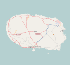
 Location of the parish seat of Cabo da Praia on the island of Terceira
| |
| Wikimedia Commons: Cabo da Praia (Praia da Vitória) | |
| Geographic detail from Instituto Geográfico Português (2010) | |
Cabo da Praia is a civil parish on the east coast of the municipality of Praia da Vitória on the Portuguese island of Terceira in the Azores. The population in 2011 was 712,[1] in an area of 3.18 km².[2]
References
- ↑ Instituto Nacional de Estatística
- ↑ Eurostat Archived September 6, 2014, at the Wayback Machine.
This article is issued from Wikipedia - version of the 11/18/2016. The text is available under the Creative Commons Attribution/Share Alike but additional terms may apply for the media files.