Cocoraque Butte Archaeological District
|
Cocoraque Butte Archaeological District | |
|
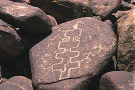
A petroglyph on Cocoraque Butte. | |
| Location | Ironwood Forest, Arizona, United States |
|---|---|
| NRHP Reference # | 75000355 |
| Added to NRHP | October 10, 1975 |
The Cocoraque Butte Archaeological District is located in Ironwood Forest National Monument, in Pima County, Arizona. Added to the National Register of Historic Places on October 10, 1975, the Cocoraque Butte Archaeological District features ancient Hohokam ruins, hundreds of well-preserved petroglyphs, and the historic Cocoraque Ranch.[1][2]
Name
Cocoraque is Spanish for "house by the butte." The O'odham name for Cocoraque Butte is "Shontok". In the O'odham language, "shon" has several meanings, one of which is the "source" or the "beginning." Shontok is thus an allusion to the source of water used to supply a hand-dug well, about twenty-five feet deep, at the Cocoraque Ranch. The well, which is still visible today, was fed by seepage from an adjacent stream, which used to flow all year round. "Shon" also means to pound, and in this regard, the O'odham visiting Cocoraque Butte suggested the place name may also refer to the pounding and pecking that was part of the technology used to produce the numerous petroglyphs at the site.[3][4]
Archaeology
Ironwood Forest National Monument is located northwest of Tucson, next to Saguaro National Park, and is administered by the Bureau of Land Management. Although only a small portion of the monument has been surveyed for cultural resources, numerous sites with preceramic, Hohokam, protohistoric, and historic occupations over a 5,000-year timespan are known within its boundaries. Three areas are listed on the National Historic Register; the Mission of Santa Ana del Chiquiburitac, the Los Robles Archaeological District, and the Cocoraque Butte Archaeological District.[1][5][6]
The Cocoraque Butte Archaeological District is adjacent to the Tohono O'odham Indian Reservation, on the westernmost edge of Avra Valley. Artesian springs at the base of the butte have attracted people during both prehistoric and historic times. The Cocoraque Ranch, located next to the butte, is one of Arizona's oldest established ranches, having been in operation since the late 1800s. The 300-acre district and adjacent properties also contain several long-term Hohokam residential sites, which were occupied from Colonial (CE 700 or 800) to Classic times (CE 1400). Cocoraque Butte stands out, however, because of the hundreds of Archaic and Hohokam petroglyph panels on top of it.[1]
In addition to diverse human, animal, and geometric elements, a number of boulders show indications of continuous tapping by prehistoric hammerstones. When tapped, each produces a distinctively different ringing tone that, in combination, create an almost surreal musical atmosphere. These sounds have even been incorporated into commercial "New Age" recordings.[1]
See also
References
- 1 2 3 4 "Archaeology Southwest: Ironwood Forest" (PDF). Paul R. Fish. 2001. Retrieved 2014-02-13.
- ↑ "National Park Service: Cocoraque Butte Archeological District". Archived from the original on 2013-02-20. Retrieved 2014-02-13.
- ↑ "History of Cocoraque Butte - Cocoraque Ranch & Pavilion". T. J. Ferguson. 2008. Retrieved 2014-02-13.
- ↑ "Cocoraque Ranch Cattle Drives Tucson Arizona". Retrieved 2014-02-14.
- ↑ "Arizona-Sonora Desert Museum: Biological Survey of Ironwood Forest National Monument". Retrieved 2014-02-13.
- ↑ "Ironwood Forest National Monument - BLM Arizona". Retrieved 2014-02-15.
