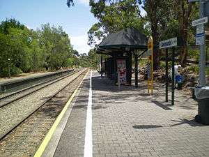
Coromandel railway station
Coromandel | |||||||||||
|---|---|---|---|---|---|---|---|---|---|---|---|
 | |||||||||||
| Location |
Brighton Parade Blackwood | ||||||||||
| Elevation | 832 feet (254 m) [1] | ||||||||||
| Line(s) | Belair Line | ||||||||||
| Distance | 17.2 km from Adelaide | ||||||||||
| Platforms | 2 (1 disused) | ||||||||||
| Bus routes | Route 197X to City | ||||||||||
| Construction | |||||||||||
| Parking | Yes | ||||||||||
| Bicycle facilities | Yes | ||||||||||
| History | |||||||||||
| Opened | 1883 | ||||||||||
| Rebuilt | 2009 | ||||||||||
| Services | |||||||||||
| |||||||||||
Coromandel railway station is located on the Belair line.[2] Situated in the Adelaide southern foothills suburb of Blackwood in South Australia, it is 17.2 kilometres from Adelaide station and 254 metres above sea level. The station opened in 1883 and was originally named Brighton Parade.[3]
In 1995, the western side platform was closed when the inbound line was converted to standard gauge as part of the One Nation Adelaide-Melbourne line gauge conversion project.
The station now consists of a single platform with a covered shelter which serves trains going in both directions.
Under the 'Adopt a Station' program run by TransAdelaide, the station was adopted by the Blackwood Neighbourhood Watch group, who have assumed responsibility for the removal of graffiti, assisting with the landscaping of the station grounds and reporting vandalism incidents.
As part of the renewal of the Belair line in 2009, improvements to access ramps, seating, fencing, lighting, signage and safety markings have taken place at Coromandel.[4][5]
References
- ↑ SAR Public Timetable 1954, pg96
- ↑ Belair timetable Archived 23 January 2015 at the Wayback Machine. Adelaide Metro 12 October 2014
- ↑ Callaghan, WH (1992). The Overland Railway. Sydney: Australian Railway Historical Society. p. 241. ISBN 0 909650 29 2.
- ↑ Belair line renewal Adelaide Metro
- ↑ Belair Line Renewal Department of Planning, Transport & Infrastructure
External links
![]() Media related to Coromandel railway station at Wikimedia Commons
Media related to Coromandel railway station at Wikimedia Commons
Coordinates: 35°01′31″S 138°36′52″E / 35.0252°S 138.6144°E