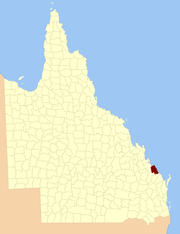
County of Flinders, Queensland
| Flinders Queensland | |||||||||||||
|---|---|---|---|---|---|---|---|---|---|---|---|---|---|
 Location within Queensland | |||||||||||||
| |||||||||||||
The County of Flinders is a county (a cadastral division) in Queensland, Australia, located in the Central Queensland region between Gladstone and Bundaberg.[1][2] It was named for Matthew Flinders who explored the Australian coastline.
The county was created on 1 September 1855 by royal proclamation under the Waste Lands Australia Act 1846.[3] On 7 March 1901, the Governor issued a proclamation legally dividing Queensland into counties under the Land Act 1897.[4] Its schedule described Flinders thus:
Bounded on the south by the counties of Cook and Bowen; on the west by the county of Yarrol, the eastern watershed of the Boyne River, and the western boundary of the parist of Rodds Bay; and on the north and east by the Pacific Ocean.
Parishes
Flinders is divided into parishes, as listed below:
References
- ↑ "Flinders (entry 12768)". Queensland Place Names. Queensland Government. Retrieved 8 September 2015.
- ↑ Port Curtis District, County of Flinders Maps – F3 Series at Queensland Archives.
- ↑ "Proclamation". New South Wales Government Gazette. 29 June 1855. p. 1855:1737–1738.
- ↑ "A Proclamation". Queensland Government Gazette. 75. 8 March 1901. pp. 967–980.
Coordinates: 24°20′S 151°34′E / 24.333°S 151.567°E
This article is issued from Wikipedia - version of the 4/4/2016. The text is available under the Creative Commons Attribution/Share Alike but additional terms may apply for the media files.