Cunninghame
Coordinates: 55°38′02″N 4°46′48″W / 55.634°N 4.780°W Cunninghame (Scottish Gaelic: Coineagan) is a former comital district of Scotland and also a district of the Strathclyde Region from 1975–1996.
Historic Cunninghame
The historic district of Cunninghame was bordered by the districts of Renfrew and Clydesdale to the north and east respectively, by the district of Kyle to the south over the River Irvine and by the Firth of Clyde to the west.
Cunninghame became one of the three districts or bailieries of Ayrshire, the shire or sheriffdom of Ayr. Cunninghame was in the north, along the River Irvine; Kyle was in the centre, along the River Ayr; and Carrick was in the south, along the River Doon. By the eighteenth century Ayrshire had become one of the counties of Scotland, with the three baileries being described as "districts" or "divisions" of the county, although they had no formal administrative existence.
In the late nineteenth century the "territorial division" was described as comprising the civil parishes of Ardrossan, Beith, Dalry, Dreghorn, Fenwick, Irvine, North Ayrshire, Kilbirnie, West Kilbride, Kilmarnock, Kilmaurs, Kilwinning, Largs, Loudoun, Stevenston, Stewarton and part of Dunlop.[1]
The Cunninghame poor law combination was formed in the 1850s with a poorhouse at Irvine. it had a different area from the ancient district.[2]
Local government district


The name was revived for one of nineteen districts of the Strathclyde region of Scotland, formed by the Local Government (Scotland) Act 1973 in 1975. The district was formed from parts of the former counties of Ayrshire and Bute, namely:
- From Ayrshire:
- The burghs of Ardrossan, Irvine, Kilwinning, Largs, Saltcoats and Stevenston
- The districts of Irvine, Kilbirnie and West Kilbride
- The parts of the districts of Ayr and Kilmarnock in the designated area of Irvine New Town
- From Bute:
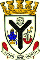
The Cunninghame District Council was granted a coat of arms by Lord Lyon King of Arms in 1979. The main feature of the arms was a black "shakefork" from the arms of Clan Cunningham. To the left was the arms of the former royal burgh of Irvine, based on the crest of the royal arms of Scotland, and said to have been granted to the town by King David I. To the right was an ancient ship which had appeared in the arms of both Bute County Council and Arran District Council. Above the shakefork was a leopard's head holding in its mouth a weaver's shuttle. this represented the weaving industry of the inland parts of the district. Such an emblem appeared in Scottish arms grants to weaving societies and associations, and in the armorial bearings of the Worshipful Company of Weavers of the City of London. The motto was Sense and Worth, and the arms were completed by a gold coronet of a design reserved by Lord Lyon to district councils, topped by thistle-heads.
The district was abolished in 1996 by the Local Government etc. (Scotland) Act 1994, when the system of regions and districts was replaced by unitary council areas. The area of the Cunninghame district (including Arran) became North Ayrshire council area.
See also
References
- ↑ Frances Groome, Ordnance Gazetteer of Scotland, 1882-4, (Vision of Britain)
- ↑ Cunninghame Combination, Ayrshire (www.workhouses.org.uk)
External links
- Blaeu Atlas of Scotland, 1654
- Counties of Scotland, 1580-1928
- John Thomson's Atlas of Scotland, 1832