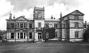
Dorlestone Hall

(from 'Staffordshire Past-Track' website)
Dorlestone Hall was a manor house at Darlaston, a locality also known as Dorlestone, near Stone, Staffordshire, England, on the Trent.
The Hall was built prior to the Reformation. Prior to 1503, the Hall was leased by Jacobus Colyar, who had probably fought in Spain during the Reconquista, as he was given a letters patent with symbols of prowess in the Crusades. In 1503, the Hall was leased by his son, Robert Colyar. He became a wool trader and married Agnes Venables de Kinderton. His son, Thurston, also leased the Hall. In 1537, its ownership passed from Burton Abbey to Thurston's son, James Collier. The abbey was dissolved two years later. In 1685, a descendant, James Collier, sold the Hall to William Jervis.
The property is associated with Richard Barnfield, who is one of the candidates for Shakespeare's "Rival Poet".[1] A "Richard Barnfield of Dorlestone in the Countie of Stafford Esquire" who died here in 1627, was formerly believed to be the poet,[2] but current thinking is that the death recorded was that of his father whose name he shared.[3]
In 1880 the estate was acquired by the Meakin family from the Jervis family.[4] The house was demolished after the Second World War.[5]
References
- ↑ Leo Daugherty, William Shakespeare, Richard Barnfield, and the Sixth Earl of Derby, Cambria Press, 2010
- ↑ For example, this was the view taken by A Short Biographical Dictionary of English Literature s:A Short Biographical Dictionary of English Literature/Barnfield, Richard
- ↑ Sonia Massai, ‘Barnfield, Richard (bap. 1574, d. 1620)’, Oxford Dictionary of National Biography, Oxford University Press, 2004 accessed 20 May 2015
- ↑ The White House, Darlaston Hall Estate, Stone. Staffordshire County Council
- ↑ Staffordshire Arts & Museum Service (2003). "Staffordshire Past Track -Aerial View of Darlaston Hall, Stone". Staffordshire County Council. Retrieved 23 July 2010.
6. R. Glover, The Visitation of Staffordshire, 1583, Historical Collections of Staffordshire, Wm. Salt Archaeological Society Publications, Vol. 3-Part 2 at 64.
Coordinates: 52°54′33″N 2°10′30″W / 52.9092°N 2.175°W