Drumohar Peak

Location of Astrolabe Island in the Antarctic Peninsula region.
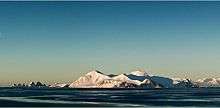
Astrolabe Island from northwest, Drumohar Peak is the left one of the two prominent mountains dominating the island.
Drumohar Peak (Bulgarian: връх Друмохар, ‘Vrah Drumohar’ \'vr&h dru-mo-'har\) is the ice-covered peak rising to 553 m in the northeastern part of Astrolabe Island off Trinity Peninsula, Antarctica.
The peak is named after the settlement of Drumohar in Western Bulgaria.
Location
Drumohar Peak is located at 63°18′26″S 58°40′55″W / 63.30722°S 58.68194°WCoordinates: 63°18′26″S 58°40′55″W / 63.30722°S 58.68194°W, which is 3.15 km east of Raduil Point and 1.9 km north-northwest of Rogach Peak. German-British mapping in 1996.
Maps
- Trinity Peninsula. Scale 1:250000 topographic map No. 5697. Institut für Angewandte Geodäsie and British Antarctic Survey, 1996.
- Antarctic Digital Database (ADD). Scale 1:250000 topographic map of Antarctica. Scientific Committee on Antarctic Research (SCAR), 1993–2016.
References
- Drumohar Peak. SCAR Composite Antarctic Gazetteer.
This article includes information from the Antarctic Place-names Commission of Bulgaria which is used with permission.
This article is issued from Wikipedia - version of the 1/29/2016. The text is available under the Creative Commons Attribution/Share Alike but additional terms may apply for the media files.