Dve Mogili Municipality
| Dve Mogili Municipality Община Две могили | |
|---|---|
| Municipality | |
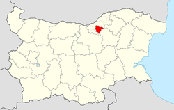
 Dve Mogili Municipality within Bulgaria and Ruse Province. | |
| Coordinates: 43°33′N 25°55′E / 43.550°N 25.917°ECoordinates: 43°33′N 25°55′E / 43.550°N 25.917°E | |
| Country |
|
| Province (Oblast) | Ruse |
| Admin. centre (Obshtinski tsentar) | Dve Mogili |
| Area | |
| • Total | 345 km2 (133 sq mi) |
| Population (December 2009)[1] | |
| • Total | 10,341 |
| Time zone | EET (UTC+2) |
| • Summer (DST) | EEST (UTC+3) |
Dve Mogili Municipality (Bulgarian: Две могили) is a municipality (obshtina) in Ruse Province, Central-North Bulgaria, located in the Danubian Plain, about 15 km southeast of Danube river. It is named after its administrative centre - the town of Dve Mogili.
The municipality embraces a territory of 345 km² with a population of 10,341 inhabitants, as of December 2009.[1]
The area is best known with Orlova Chuka cave. Accidentally discovered in 1941, with its 13,437 m, it is the second-longest in the country.
The main road E85 touches the northwest border of the municipality, connecting the province centre of Ruse with the cities of Veliko Tarnovo and respectively Pleven and Sofia.
Settlements
.png)
Dve Mogili Municipality includes the following 12 places (towns are shown in bold):
| Town/Village | Cyrillic | Population[2][3][4] (December 2009) |
|---|---|---|
| Dve Mogili | Две могили | 4,342 |
| Baniska | Баниска | 1,291 |
| Bazovets | Бъзовец | 938 |
| Batishnitsa | Батишница | 709 |
| Chilnov | Чилнов | 509 |
| Karan Varbovka | Каран Върбовка | 448 |
| Katselovo | Кацелово | 841 |
| Mogilino | Могилино | 337 |
| Ostritsa | Острица | 354 |
| Pomen | Помен | 440 |
| Pepelina | Пепелина | 30 |
| Shirokovo | Широково | 102 |
| Total | 10,341 |
Demography
The following table shows the change of the population during the last four decades.
| Dve Mogili Municipality | ||||||||
|---|---|---|---|---|---|---|---|---|
| Year | 1975 | 1985 | 1992 | 2001 | 2005 | 2007 | 2009 | 2011 |
| Population | 16,876 | 15,138 | 14,027 | 12,116 | 11,297 | 10,851 | 10,341 | ... |
| Sources: Census 2001,[5] Census 2011,[6] „pop-stat.mashke.org“,[7] | ||||||||
References
- 1 2 (English) Bulgarian National Statistical Institute - Bulgarian provinces and municipalities in 2009
- ↑ (English) Bulgarian National Statistical Institute - Bulgarian towns in 2009
- ↑ (English) Bulgarian National Statistical Institute - Bulgarian villages under 1000 inhabitants - December 2009
- ↑ (English) Bulgarian National Statistical Institute - Bulgarian Settlements 1000-5000 inhabitants - December 2009
- ↑ (English)National Statistical Institute - Census 2001
- ↑ „pop-stat.mashke.org“
- ↑ "Population of Bulgarian divisions". Pop-stat.mashke.org. 2011-02-01. Retrieved 2012-03-28.
External links
- Official website (English)
 |
Borovo Municipality, Ruse Province | Ivanovo Municipality, Ruse Province | Tsar Kaloyan Municipality, Razgrad Province |  |
| Borovo Municipality, Ruse Province | |
Opaka Municipality, Targovishte Province | ||
| ||||
| | ||||
| Byala Municipality, Ruse Province | Popovo Municipality, Targovishte Province |