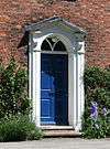
Dysart Buildings, Nantwich

Dysart Buildings is a terrace of nine Georgian houses on Monks Lane in Nantwich, Cheshire, England. Dating from 1778–79, the building is listed at grade II*.[1] It is located at 1–9 Monks Lane (SJ6534252361), now a pedestrian walkway, opposite the former Congregational Chapel and immediately north east of St Mary's Church. Nikolaus Pevsner describes the building as "surprisingly metropolitan".[2]
History

The terrace was constructed in 1778–79 as a speculative project by Lionel Tollemache, the fifth Earl of Dysart, who inherited the land from an ancestor who married into the Wilbraham family in 1680.[3][4] The Earl of Dysart was also patron of St Mary's Church in the adjacent parish of Acton.[5]
Description
%2C_Nantwich.jpg)
Dysart Buildings is a terrace of nine three-storey town houses in red brick under a slate roof.[1] The front (south) face is symmetrical, and Pevsner describes the terrace as "perfectly even".[2] Each of the individual houses has three bays. The entrance doors all feature wooden doorcases with flanking pilasters and fanlights topped with a pediment; the windows all have plain tops and stone sills.
At the ends of the terrace are projecting bays. The west end has an additional later extension.[1] Each end of the terrace bears an oval plaque with the name of the building.[6]
See also
References
- 1 2 3 Historic England. "Dysart Buildings, Nantwich (1249422)". National Heritage List for England. Retrieved 11 August 2012.
- 1 2 Pevsner N, Hubbard E. The Buildings of England: Cheshire, p. 287 (Penguin Books; 1971) (ISBN 0-14-071042-6)
- ↑ Stevenson PJ. Nantwich: A Brief History and Guide, p. 30 (1994)
- ↑ Whatley A. Nantwich in Old Picture Postcards: 1880–1930, plate 70 (European Library; 1992) (ISBN 90-288-5380-4)
- ↑ Hall J. A History of the Town and Parish of Nantwich, or Wich Malbank, in the County Palatine of Chester (2nd edn), p. 265 (E. J. Morten; 1972) (ISBN 0-901598-24-0)
- ↑ Bavington G et al. Nantwich, Worleston & Wybunbury: A Portrait in Old Picture Postcards, plate 6 (Brampton Publications; 1987) (ISBN 0-9511469-6-3)
Coordinates: 53°04′02″N 2°31′07″W / 53.0673°N 2.5186°W