Els Omells de na Gaia
| Els Omells de na Gaia | |||
|---|---|---|---|
| Municipality | |||
 | |||
| |||
 Els Omells de na Gaia Location in Catalonia | |||
| Coordinates: 41°30′08″N 1°04′37″E / 41.50222°N 1.07694°ECoordinates: 41°30′08″N 1°04′37″E / 41.50222°N 1.07694°E | |||
| Country |
| ||
| Community |
| ||
| Province | Lleida | ||
| Comarca | Urgell | ||
| Government | |||
| • mayor | Delfi Escoté Salla (2015)[1] | ||
| Area[2] | |||
| • Total | 13.5 km2 (5.2 sq mi) | ||
| Elevation | 560 m (1,840 ft) | ||
| Population (2014)[1] | |||
| • Total | 141 | ||
| • Density | 10/km2 (27/sq mi) | ||
| Demonym(s) | Omellenc, omellenca | ||
| Website |
omellsdenagaia | ||
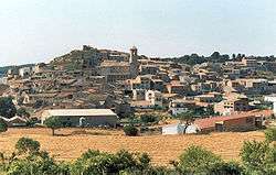
Els Omells de na Gaia is a municipality in the comarca of the Urgell in Catalonia, Spain. It is located north of the Serra del Tallat, Catalan Pre-Coastal Range, at the southern end of the comarca.
The town centre has medieval stone houses. The Església parroquial de Santa Maria is an 18th-century church that houses some ancient carved wood images. Els Omells de na Gaia is in an economically depressed area, the main income is derived from cereal, vineyard and almond cultivation, as well as some cattle.
Demography
| 1900 | 1930 | 1950 | 1970 | 1986 | 2006 |
|---|---|---|---|---|---|
| 641 | 624 | 481 | 276 | n/a | 159 |
References
- 1 2 "Ajuntament dels Omells de na Gaia". Generalitat of Catalonia. Retrieved 2015-11-13.
- ↑ "El municipi en xifres: Els Omells de na Gaia". Statistical Institute of Catalonia. Retrieved 2015-11-23.
External links
| Wikimedia Commons has media related to Els Omells de na Gaia. |
- Pàgina web de l'Ajuntament
- Informació de la Generalitat de Catalunya
- Informació de l'Institut d'Estadística de Catalunya (Catalan)
 |
Maldà | Vallbona de les Monges |  | |
| L'Espluga Calba | |
|||
| ||||
| | ||||
| Senan |
This article is issued from Wikipedia - version of the 1/25/2016. The text is available under the Creative Commons Attribution/Share Alike but additional terms may apply for the media files.

