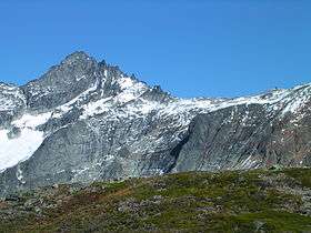
Forbidden Peak
| Forbidden Peak | |
|---|---|
 | |
| Highest point | |
| Elevation | 8,815 ft (2,687 m) NGVD 29[1] |
| Prominence | 1,055 ft (322 m) [1] |
| Coordinates | 48°30′41″N 121°03′28″W / 48.5115158°N 121.0578916°WCoordinates: 48°30′41″N 121°03′28″W / 48.5115158°N 121.0578916°W [2] |
| Geography | |
| Location | near Cascade Pass, Skagit County, Washington, U.S. |
| Parent range | North Cascades |
| Topo map | USGS Forbidden Peak |
| Climbing | |
| First ascent | June 1, 1940 by Lloyd Anderson, Fred Beckey, Helmy Beckey, Jim Crooks, Dave Lind[3] |
Forbidden Peak is part of the North Cascades and is located near Cascade Pass. Forbidden Peak features a rock climbing route named West Ridge route which is featured in Fifty Classic Climbs of North America.[4]
References
- 1 2 "Forbidden Peak, Washington". Peakbagger.com.
- ↑ "Forbidden Peak". Geographic Names Information System. United States Geological Survey.
- ↑ Beckey, Fred W. (2003). Cascade alpine guide : climbing and high routes. Vol. 2, Stevens Pass to Rainy Pass (3rd ed.). Mountaineers Books. p. 322. ISBN 978-0-89886-838-8.
- ↑ Roper, Steve; Steck, Allen (1979). Fifty Classic Climbs of North America. San Francisco: Sierra Club Books. pp. 113–117. ISBN 0-87156-292-8.
External links
 Media related to Forbidden Peak at Wikimedia Commons
- "Washington Bulger List". Peakbagger.com.
- "Forbidden Peak". SummitPost.org.
- Davis, J Lee. "Forbidden Peak". Peakware.com.
- "Forbidden Peak". MountainProject.com.
This article is issued from Wikipedia - version of the 12/6/2015. The text is available under the Creative Commons Attribution/Share Alike but additional terms may apply for the media files.