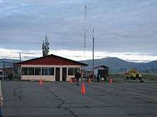
Francisco Carle Airport
| Francisco Carle Airport Jauja Airport | |||||||||||
|---|---|---|---|---|---|---|---|---|---|---|---|
 | |||||||||||
| IATA: JAU – ICAO: SPJJ | |||||||||||
| Summary | |||||||||||
| Airport type | Public | ||||||||||
| Operator | CORPAC | ||||||||||
| Location | Jauja | ||||||||||
| Elevation AMSL | 11,034 ft / 3,363 m | ||||||||||
| Coordinates | 11°47′00″S 75°28′25″W / 11.78333°S 75.47361°WCoordinates: 11°47′00″S 75°28′25″W / 11.78333°S 75.47361°W | ||||||||||
| Map | |||||||||||
 JAU Location of the airport in Peru | |||||||||||
| Runways | |||||||||||
| |||||||||||
Francisco Carle Airport (IATA: JAU, ICAO: SPJJ) is a high-elevation regional airport serving Jauja, in the Junin Region of Peru, and surrounding cities as Huancayo or Tarma. It is currently served by one scheduled airline: LC Perú. Most travelers traveling to domestic and international destination connect in Lima's Jorge Chávez International Airport.
Airlines and destinations
| Airlines | Destinations |
|---|---|
| LC Perú | Lima |
See also
References
- ↑ Airport information for JAU at Great Circle Mapper.
- ↑ Google Maps Jauja
External links
- Airport information for SPJJ at World Aero Data. Data current as of October 2006.
- OurAirports - Jauja
- SkyVector - Francisco Carle
- OpenStreetMap - Jauja
This article is issued from Wikipedia - version of the 9/26/2016. The text is available under the Creative Commons Attribution/Share Alike but additional terms may apply for the media files.