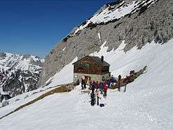
Fritz Pflaum Hut
| Fritz Pflaum Hut | |
|---|---|
 | |
 Fritz Pflaum Hut Fritz Pflaum Hut (Austria) | |
| Coordinates | 47°33′51″N 12°20′14″E / 47.56417°N 12.33722°ECoordinates: 47°33′51″N 12°20′14″E / 47.56417°N 12.33722°E |
| Country | Austria |
| Administrative district | Tirol |
| Mountain range | Kaiser Mountains |
| Elevation | 1,865 m (6,119 ft) AA |
| Construction | |
| Built in | 1912 |
| Administration | |
| Hut type | DAV self-service hut Category I |
| Owner | German Alpine Club (DAV) - Bayerland Section |
| Website |
www |
| Facilities | |
| Mattresses | 23[1][2] |
| Footnotes | |
| Hut reference | OeAV DAV |
The Fritz Pflaum Hut (German: Fritz-Pflaum-Hütte) is an Alpine club hut belonging to the Bayerland Section of the German Alpine Club,[3][1] located in the Kaisergebirge mountains in the Austrian federal state of Tyrol.[4]
Location
The Fritz Pflaum Hut is an unmanned climbers' hut high above the Kaiserbachtal that lies in the Griesner Cirque (Griesner Kar) at the foot of the Mitterkaiser.[1] It is located at a height of 1,865 metres (6,119 ft)[5][6] and is thus the highest hut in the Wilder Kaiser. It is accessible with an Alpine Club key (AV-Schlüssel), but a guardian is only present for group bookings.[3][1] The hut is a base for all summits around the Griesener Kar bowl as well as a starting point for the Kleinkaiser and Mitterkaiser peaks. It has 23 bedspaces.[2]
History
The hut was named after the Alpinist, Fritz Pflaum,[7] who was born in 1871. He was a keen nature lover and sportsman and loved the Wilder Kaiser. On 25 August 1908 he died during a difficult mountain tour on the Mönch.[8] Relatives, friends and acquaintances donated 8,000 marks for the construction of the Fritz Pflaum Hut, which was opened on 25 August 1912, exactly four years after his death.[9] Subsequent attempts to rename it the Griesnerkar Hut have not succeeded. An attempt to provide a basic managed service in the spring of 2007 failed because of a ban by the district commission.
Approaches
The normal approach to the hut is from the Griesner Alm in the Kaiserbach valley over a good path with numerous bends that takes 2 1⁄2 hours as a mountain hike[1] and 2 1⁄4 hours as a ski tour[10] (height difference: 870 metres (2,850 ft)).
The alternative is a rarely used climb from the Fischbachalm, also down in the Kaiserbach valley, via the pine oil distillery (Latschenölbrennerei) and the Kleiner Griesner Tor which takes 2 hours.[1] This route is rather more challenging and requires sure-footedness. Some sections are protected by cable.[1]
Crossings
- Gaudeamus Hut (1,270 m (4,170 ft)), via the Kleines Törl, Gildensteig and Wildererkanzel, duration: 3 1⁄2 hours
- Ackerl Hut (1,460 m (4,790 ft)), via the Kleines Törl, Gildensteig and Wilder Kaiser Path, duration: 3 hours
- Ackerl Hut (1,460 m (4,790 ft)), via the Ackerlspitze and Maukspitze, challenging, duration: 5 hours
- Grutten Hut (1,620 m (5,310 ft)), via the Kleines Törl, Gildensteig, Wilder Kaiser Path, Jubiläumssteig, duration: 4 hours
- Stripsenjochhaus (1,577 m (5,174 ft)), via the Großes Griesner Tor, Hüttenweg, easy, duration: 2 1⁄2 hours
Ascents
The following ascents are listed by the DAV:[7]
- Ackerlspitze (2,329 m (7,641 ft)), duration: 2 hours, medium difficulty
- Lärcheck (2,124 m (6,969 ft)), duration: 2¼ hours, difficult
- Mitterkaiser (2,007 m (6,585 ft)), duration: ½-1 hour, medium difficulty
- Regalmspitze (2,249 m (7,379 ft)), duration: 2 hours, difficult
- Maukspitze (2,231 m (7,320 ft)_, duration of crossing: 1 hour, difficult
References
- 1 2 3 4 5 6 7 Höfler, Horst and Piepenstock Jan. Kaisergebirge. Munich: Rother, 12th edn., 2006, p. 42.
- 1 2 Schubert, Pit. Kaisergebirge - extrem. Munich: Rother (2000). p. 26. ISBN 3-7633-1272-2
- 1 2 Reynolds, Kev (2009). Walking in Austria, 1st ed., Cicerone, Milnthorpe, p. 265, ISBN 978-1-85284-538-4.
- ↑ Fritz-Pflaum-Hütte at www.alpenverein.at. Retrieved 5 Dec 2015.
- ↑ Fritz-Pflaum-Hütte, 1865 m at www.alpenverein.de. Retrieved 5 Dec 2015.
- ↑ Reynolds gives its height as 1868 m, the Alpine Club Guide as 1866 m.
- 1 2 Die Fritz-Pflaum-Hütte at www.alpenverein-bayerland.de. Retrieved 5 Dec 2015.
- ↑ Stephen, Sir Leslie; Freshfield, Douglas William; Conway, Sir William Martin; Butler, Arthur John and Yeld, George. The Alpine Journal, Vol. 24, London: The Alpine Club (1909), p. 350.
- ↑ Kühntopf, Michael. Juden, Juden, Juden. Germany: Books on Demand (2008), p. 79. ISBN 978-3-8334-8629-6.
- ↑ Brandl, Sepp. Berchtesgadener und Chiemgauer Alpen: mit Kaiser und Steinbergen. Munich: Rother, 2015. ISBN 978-3-7633-5906-6.
External links
- Bayerland Section of the DAV (German)
- The climbing garden (Klettergarten) at Fritz Pflaum Hut (German)