Fuling District
| Fuling 涪陵区 | |
|---|---|
| District | |
|
| |
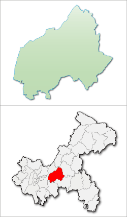
 Fuling District in Chongqing | |
| Coordinates: 29°42′11″N 107°23′21″E / 29.70306°N 107.38917°E | |
| Country | People's Republic of China |
| Municipality | Chongqing |
| Area | |
| • Total | 2,946 km2 (1,137 sq mi) |
| Elevation | 287 m (942 ft) |
| Population (2015) | 1,161,800 |
| Time zone | China Standard (UTC+8) |
| Fuling | |||||||||
| Traditional Chinese | 涪陵 | ||||||||
|---|---|---|---|---|---|---|---|---|---|
| Simplified Chinese | 涪陵 | ||||||||
| Postal | Fowling | ||||||||
| |||||||||
Fuling (simplified Chinese: 涪陵区; traditional Chinese: 涪陵區; pinyin: Fúlíng Qū) is a district in the geographical center of Chongqing Municipality, China. Its name means "Fu (River) mausoleum" because some rulers of the State of Ba were buried there.
Fuling's zha cai, a hot pickled mustard tuber, is its signature product.[1]
Fuling is also the location of former U.S. Peace Corps teacher Peter Hessler's best-selling memoir River Town: Two Years on the Yangtze.
- Area: 2,941.47 km2 (1,135.71 sq mi)
- Population: 1,066,700 (2010)
- Geographic coordinates: 106°56' – 107°43' East, 29°21'– 30°01' North
History
In the middle and late part of Spring and Autumn period, it was in the southern territory of the State of Ba. In the middle Warring States period, it was part of the State of Chu. It was called the County of Zhi (枳县) in 277 by the State of Qin. In 347 (during the Eastern Jin Dynasty), it became Commandery of Fu (涪郡), also known as Commandery of Zicheng (梓城郡). It became County of Fuling (县) in the Sui Dynasty. It was Fu Prefecture (州) in 618 (during the Tang Dynasty). From the Yuan to the Qing Dynasty, Fu Department was part of Chongqing Prefecture (府). In the early years of the Republic of China, Fuling County was a part of Dongchuan Circuit (东川) until 1928 it became part of Sichuan province.
In January 1950, Fuling Zhuanqu of Chuandong include the seven counties of:
In September 1952, Youyang Zhuanqu was abolished, and its counties of Qianjiang, Youyang, and Xiushan were incorporated into Fuling Zhuanqu. The following year, Dianjiang County was also assigned to Fuling. Fuling's Changshou became under Chongqing City in 1958. The zhuanqu was made a prefecture in 1968.
Fuling County was upgraded to a county-level city in 1983. The prefecture became a Three Gorges provincial planning region (三峡省筹备区域) the following year. In 1988, the counties of Qianjiang, Youyang, Shizhu, Xiushan, and Pengshui were separated into new prefecture of their own (Qianjiang Prefecture).
On November 5, 1995, Fuling Prefecture and the original county-level city were abolished. In the replace of the prefecture was the prefectural Fuling City, administer the three counties of Dianjiang, Wulong, and Fengdu, and Nanchuan City. It also includes the newly established districts of Zhicheng and Lidu (枳城 and 李渡).
The city was administered by Chongqing since September 1996 on behalf of the province, and became part of Chongqing Municipality the following year. In June 1998, Fuling city and its two districts were abolished. The districts became Fuling District. The remaining subdivisions of the Fuling City persisted, but were directly governed by Chongqing.
Climate
Fuling District has a monsoon-influenced humid subtropical climate (Köppen Cwa), with four distinct seasons and ample rainfall: winters are short, mild, and comparatively dry, while summers are long, hot, and humid. Monthly daily average temperatures range from 7.4 °C (45.3 °F) in January to 28.4 °C (83.1 °F) in August, while the annual mean is 18.04 °C (64.5 °F). The diurnal temperature variation is 6.52 °C (11.7 °F) and is especially small during winter. Around 87% of the annual precipitation falls from April to October.
| Climate data for Fuling District (1971–2000) | |||||||||||||
|---|---|---|---|---|---|---|---|---|---|---|---|---|---|
| Month | Jan | Feb | Mar | Apr | May | Jun | Jul | Aug | Sep | Oct | Nov | Dec | Year |
| Record high °C (°F) | 16.9 (62.4) |
23.9 (75) |
32.5 (90.5) |
35.5 (95.9) |
37.9 (100.2) |
39.2 (102.6) |
40.5 (104.9) |
42.2 (108) |
41.8 (107.2) |
35.5 (95.9) |
28.9 (84) |
18.4 (65.1) |
42.2 (108) |
| Average high °C (°F) | 9.7 (49.5) |
12.1 (53.8) |
16.9 (62.4) |
22.5 (72.5) |
26.6 (79.9) |
29.2 (84.6) |
33.0 (91.4) |
33.9 (93) |
28.0 (82.4) |
22.0 (71.6) |
16.6 (61.9) |
11.2 (52.2) |
21.8 (71.3) |
| Daily mean °C (°F) | 7.4 (45.3) |
9.2 (48.6) |
13.3 (55.9) |
18.1 (64.6) |
22.0 (71.6) |
24.9 (76.8) |
28.1 (82.6) |
28.4 (83.1) |
23.8 (74.8) |
18.5 (65.3) |
13.8 (56.8) |
9.0 (48.2) |
18.0 (64.4) |
| Average low °C (°F) | 5.7 (42.3) |
7.1 (44.8) |
10.5 (50.9) |
14.9 (58.8) |
18.7 (65.7) |
21.6 (70.9) |
24.3 (75.7) |
24.4 (75.9) |
20.8 (69.4) |
16.2 (61.2) |
11.8 (53.2) |
7.5 (45.5) |
15.3 (59.5) |
| Record low °C (°F) | −1.5 (29.3) |
−0.3 (31.5) |
1.3 (34.3) |
4.2 (39.6) |
11.5 (52.7) |
15.8 (60.4) |
19.4 (66.9) |
18.7 (65.7) |
14.9 (58.8) |
7.4 (45.3) |
3.0 (37.4) |
−2.2 (28) |
−2.2 (28) |
| Average precipitation mm (inches) | 17.0 (0.669) |
16.9 (0.665) |
41.5 (1.634) |
116.7 (4.594) |
176.2 (6.937) |
188.3 (7.413) |
153.0 (6.024) |
118.4 (4.661) |
114.2 (4.496) |
111.7 (4.398) |
53.8 (2.118) |
22.9 (0.902) |
1,130.6 (44.511) |
| Average precipitation days (≥ 0.1 mm) | 8.9 | 9.0 | 11.7 | 15.7 | 16.1 | 16.0 | 13.1 | 10.9 | 13.3 | 15.4 | 11.9 | 9.4 | 151.4 |
| Source: Weather China[2] | |||||||||||||
Demographics
According to Peter Hessler, as of 1998, most residents of Fuling are genetically incapable of being alcoholics. When imbibing large amounts of alcohol many people became so sick and they could not drink heavily all the time. Therefore, according to Hessler, consumption of alcohol was not habitual but instead was a ritual, and therefore drinking patterns were "abusive with light consequences."[3]
Administrative divisions
There are eight sub-districts, 18 towns, and 14 townships. They in turn contain 719 administrative villages and 80 neighborhood committees (see administrative levels in China).
| Name | Chinese (S) | Hanyu Pinyin | Population (2010)[4] |
|---|---|---|---|
| Dunren Subdistrict | 敦仁街道 | Dūnrén Jiēdào | 105,296 |
| Chongyi Subdistrict | 崇义街道 | Chóngyì Jiēdào | 75,746 |
| Lizhi Subdistrict | 荔枝街道 | Lìzhī Jiēdào | 156,753 |
| Jiangbei Subdistrict | 江北街道 | Jiāngběi Jiēdào | 36,538 |
| Jiangdong Subdistrict | 江东街道 | Jiāngdōng Jiēdào | 51,078 |
| Lidu Subdistrict | 李渡街道 | Lǐdù Jiēdào | 88,124 |
| Longqiao Subdistrict | 龙桥街道 | Lóngqiáo Jiēdào | 34,541 |
| Baitao Subdistrict | 白涛街道 | Báitāo Jiēdào | 46,160 |
| Nantuo Town | 南沱镇 | Nántuó Zhèn | 26,447 |
| Qingyang Town | 青羊镇 | Qīngyáng Zhèn | 16,197 |
| Baisheng Town | 百胜镇 | Bǎishèng Zhèn | 41,114 |
| Zhenxi Town | 珍溪镇 | Zhēnxī Zhèn | 50,017 |
| Qingxi Town | 清溪镇 | Qīngxī Zhèn | 29,285 |
| Jiaoshi Town | 焦石镇 | Jiāoshí Zhèn | 23,454 |
| Mawu Town | 马武镇 | Mǎwǔ Zhèn | 32,360 |
| Longtan Town | 龙潭镇 | Lóngtán Zhèn | 36,511 |
| Linshi Town | 蔺市镇 | Lìnshì Zhèn | 41,730 |
| Xinmiao Town | 新妙镇 | Xīnmiào Zhèn | 34,299 |
| Shituo Town | 石沱镇 | Shítuó Zhèn | 26,144 |
| Yihe Town | 义和镇 | Yìhé Zhèn | 37,390 |
| Luoyun Township | 罗云乡 | Luōyún Xiāng | 14,940 |
| Damu Township | 大木乡 | Dàmù Xiāng | 3,200 |
| Wulingshan Township | 武陵山乡 | Wǔlíngshān Xiāng | 6,360 |
| Dashun Township | 大顺乡 | Dàshùn Xiāng | 18,844 |
| Zengfu Township | 增福乡 | Zēngfú Xiāng | 15,527 |
| Tongle Township | 同乐乡 | Tónglè Xiāng | 18,659 |
Transportation
Historically, Fuling was primarily served by Yangtze river boats, as the development of ground transportation was slow, due to the difficult terrain.
Railways arrived to the Fuling area only in the 21st century. First was the Chongqing–Huaihua Railway, completed in 2005. Its Fuling Railway Station is located a few kilometers west of town (29°42′10″N 107°19′45″E / 29.70278°N 107.32917°E).
The high-speed Chongqing−Lichuan Railway, opened on December 28, 2013, serves Fuling as well, with its Fuling North Railway Station. This railway crosses the Yangtze near the city over the Hanjiatuo Bridge. The railway's Caijiagou Bridge (蔡家沟特大桥; 29°46′17″N 107°22′07″E / 29.77139°N 107.36861°E), located in Fuling District, is said to be the world's tallest railway bridge, as measured by the height of the bridge's tallest pillar (139 m).[5] The Nanchuan–Fuling Railway, completed in 2012, forms part of Chongqing's outer railway ring.
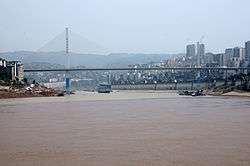
As of 2015, Fuling had five Yangtze River bridges.
Education
Yangtze Normal University (formerly Fuling Teachers College) is in Fuling.
Culture
The White Crane Ridge (Baiheliang), a rock outcrop on the Yangtze River, has been used as a hydrological station recording water levels since the Tang Dynasty. It includes many rock carvings. With the flooding of the Yangtze as part of the Three Gorges Dam project, the White Crane Ridge Underwater Museum was opened in 2009 to protect the carvings and allow viewing by visitors under the new water level of the river.[6]
Notes
- ↑ United States Foreign Broadcast Information Service. Daily Report: People's Republic of China, Issues 224–231. National Technical Information Service, 1990. p. 31. "Fuling is famous for its hot pickled mustard tubers and Comrade Qiao Shi showed a keen interest in the production and processing of these tubers. Early the next morning, he went to Fuling's Zhaxi Hot Pickled Mustard Tuber Factory by car.[...]"
- ↑ Weather China
- ↑ Hessler, p. 80.
- ↑ shi, Guo wu yuan ren kou pu cha ban gong; council, Guo jia tong ji ju ren kou he jiu ye tong ji si bian = Tabulation on the 2010 population census of the people's republic of China by township / compiled by Population census office under the state; population, Department of; statistics, employment statistics national bureau of (2012). Zhongguo 2010 nian ren kou pu cha fen xiang, zhen, jie dao zi liao (Di 1 ban. ed.). Beijing Shi: Zhongguo tong ji chu ban she. ISBN 978-7-5037-6660-2.
- ↑ 渝利铁路139米世界最高 成都到上海时间缩短 (Yu-Li Railway's world's highest 139 m [pillar]; will shorten Chengdu-Shanghai travel time), 2012-08-26 (Chinese)
- ↑ Hessler, Peter (March 2013). "Fuling, China: Return to River Town". National Geographic. Retrieved 24 September 2014.
Bibliography
- Hessler, Peter. River Town: Two Years on the Yangtze (ebook edition). HarperCollins e-books.
External links
| Wikimedia Commons has media related to Fuling District. |
- Official site (Chinese)
- Hot Pickled Mustard Tuber
- Reviews and excerpts of River Town by Peter Hessler
- Resort: Baiheliang 白鹤梁
Coordinates: 29°39′37″N 107°17′06″E / 29.6603°N 107.285°E


