Galfa Tower
| Galfa Tower (italian: Torre Galfa) | |
|---|---|
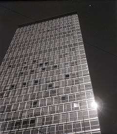
 The Galfa Tower photographed by Paolo Monti in 1965 | |
| General information | |
| Location | Milan, Italy |
| Construction started | 1956 |
| Completed | 1959 |
| Owner | UnipolSai Insurance (Unipol Group) |
| Height | |
| Roof | 102 m (335 ft) |
| Top floor | 31[1] |
| Technical details | |
| Floor area | 26,100 m2 (281,000 sq ft)[2] |
| Lifts/elevators | 7 |
| Design and construction | |
| Architect | Melchiorre Bega |
| Main contractor | Sarom |
The Galfa Building or Galfa Tower (Torre Galfa in Italian) is a skyscraper in Milan, Italy, located in the Centro Direzionale di Milano district, north of the city centre. It was designed by architect Melchiorre Bega in 1956 and completed in 1959. The name "Galfa" is a portmanteau derived from the names of the two streets where the tower has its facades, Via Galvani and Via Fara. The building is 102 m and 31 floors high, with 2 more underground floors, and qualifies as the eleventh highest skyscraper in Milan.
The overall design of the tower is mainly based on the International Style architecture. The building is rectangular, with the two lowest floors larger than the main body. The main structure in reinforced concrete is almost completely hidden by curtain walls made of glass and aluminium.
The tower was originally built for the Sarom company; in the mid-1970s, it was sold by Sarom to the Popolare di Milano bank, and thereafter served as a service centre and headquarter of the bank. In 2006, Popolare sold the building for 48 million euros to Fondiaria Sai Group.
On 5 May 2012, the building was occupied by a group of people which intended to create a space for artists; the project's name was Macao.[3] The building was cleared by the authorities ten days later; anyway, project Macao remained, and Milan's Major Giuliano Pisapia promised to provide it another seat.[4]
The Unipol Group, that acquired Fondiaria-Sai in 2012, has just taken possession of the building, has started together with The Council of Milan the study on the project of requalification and valorisation of the tower and its vicinity with the objective of starting the work within 2014.[5][6]
References
- ↑ Gruppo Sai Fondiaria - 2006 third quarter report (Pag. 35)
- ↑ Immobiliare Lombarda
- ↑ "Torre Galfa come il Teatro Valle a Garibaldi scatta l'occupazione". la Repubblica. 5 May 2012. Retrieved 13 May 2012.
- ↑
- ↑ Torre Galfa, parte il progetto di riqualificazione
- ↑ Articolo "L'edificio sarà riqualificato: Comune e Unipol lavorano insieme al progetto", del 10 gennaio 2014, sul sito del Comune di Milano.
Coordinates: 45°29′11″N 9°11′56″E / 45.48639°N 9.19889°E