Goldfield Historic District
|
Goldfield Historic District | |
|
Nevada Historical Marker #14 | |
|
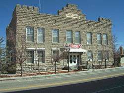
Esmeralda County Courthouse | |
  | |
| Location | Roughly bounded by 5th Street and Miner, Spring, Crystal and Elliott Avenues, Goldfield, Nevada |
|---|---|
| Coordinates | 37°42′31″N 117°14′3″W / 37.70861°N 117.23417°WCoordinates: 37°42′31″N 117°14′3″W / 37.70861°N 117.23417°W |
| Area | 200 acres (81 ha) |
| Built | 1902 et seq |
| Architect | various |
| Architectural style | Late 19th And 20th Century Revivals, Bungalow/Craftsman, Georgian Revival |
| NRHP Reference # | 82003213 |
| MARKER # | 14 |
| Added to NRHP | June 14, 1982 |
Goldfield Historic District is a historic district located in the center of Goldfield, Esmeralda County, Nevada. Roughly bounded by 5th Street and Miner, Spring, Crystal and Elliott avenues, the district encompasses 200 acres (81 ha) of the unincorporated community of Goldfield. The district contains nearly 120 buildings, most dating from the time of Goldfield's initial boom, 1904 to 1909. Goldfield became a regional and national center of attention during Nevada's twentieth century mining boom, comparable to the Great Comstock era in the previous century.[1]
On June 14, 1982 the district was listed on the National Register of Historic Places.[1]
Contributing properties
Contributing properties in the district include:
- Goldfield High School[2]
- Goldfield Hotel
- Esmeralda County Courthouse
References
- 1 2 James Woodward; James Garrison; Cindy Myers; Lynn Drobbin (August 1981). "National Register of Historic Places Nomination Form: Goldfield Historic District and Goldfield Historic Property Survey" (PDF). National Park Service. Retrieved 2014-12-11.Photos
- ↑ "Goldfield High School". Preserve Nevada. Retrieved 2011-05-06.
Goldfield High School, 2009
| Wikimedia Commons has media related to Goldfield, Nevada. |
This article is issued from Wikipedia - version of the 11/27/2016. The text is available under the Creative Commons Attribution/Share Alike but additional terms may apply for the media files.
