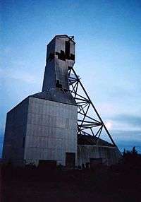
Gunnar Mine
|
The headframe at the Gunnar Mine | |
| Location | |
|---|---|
 Gunnar Mine Location in Saskatchewan | |
| Location | Athabasca Basin |
| Province | Saskatchewan |
| Country | Canada |
| Coordinates | 59°23′06″N 108°53′13″W / 59.385°N 108.887°WCoordinates: 59°23′06″N 108°53′13″W / 59.385°N 108.887°W |
| Production | |
| Products | Uranium |
| History | |
| Opened | 1955 |
| Closed | 1963 |
| Owner | |
| Company | Gunnar Mines Ltd |
| Year of acquisition | 1952 (discovery) |
The Gunnar Mine was a uranium mine in northern Saskatchewan, Canada located around 25 kilometres (16 mi) southwest of the community of Uranium City. The mine was situated on the Crackingstone Peninsula on the north shore of Lake Athabasca in the Beaverlodge Uranium District.
The Gunnar deposit was discovered in July 1952 and operated as both an open pit (1955–1961) and underground (1957–1963) mine.[1] The mine ceased production in 1963.
The Gunnar Mine headframe was demolished on August 4, 2011.[2]
See also
References
- ↑ Saskatchewan Research Council (April 2007), Former Gunnar Mining Limited Site Rehabilitation Project Proposal (PDF), SRC, p. 1, retrieved 2009-10-25
- ↑ "Gunnar Mine headframe safely taken down.". Cleans. Retrieved 2012-03-21.
External links
- "2007-068, SRC, rehabilitation of the former Gunnar mine site". Government of Saskatchewan. Retrieved 2015-01-13.
- "Saskatchewan Makes Recommendations on Former Uranium Mine Sites". Government of Saskatchewan. Retrieved 2009-10-25.
- "MINING: Quick Facts". Canadian Parks and Wilderness Society - Saskatchewan Chapter. Retrieved 2009-10-25.
- "Gunnar". Cleanup of Abandoned Northern Sites (CLEANS). Retrieved 2009-12-12.
This article is issued from Wikipedia - version of the 7/14/2016. The text is available under the Creative Commons Attribution/Share Alike but additional terms may apply for the media files.
