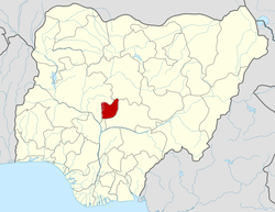
Gwagwalada
| Gwagwalada Area Council | |
|---|---|
| LGA and town | |
| Country |
|
| State | Federal Capital Territory |
| Headquarters | Gwagwalada |
| Government | |
| • Hon. | Adamu Mustapha Danze |
| Time zone | WAT (UTC+1) |
| 6-digit postal code | 902101 |
| Area code(s) | NG.AB.GW |
| Website | http://www.fctacss.org.ng/index.php/area-councils/gwagwalada-area-council |
Gwagwalada is one of the six Local Government Area Councils of the Federal Capital Territory of Nigeria, together with Abaji, Kuje, Bwari, and Kwali; and the Abuja Municipal Area Council (AMAC). Gwagwalada is also the name of the main town in the Local Government Area, which has an area of 1,043 km² and a population of 157,770 at the 2006 census.
History
Before the creation of Federal Capital Territory, Gwagwalada was under the Kwali District of the former Abuja emirate now Suleja emirate. Gwagwalada Area Council was created on the 15th October, 1984. Its official population figure of 158,618 people at the 2006 census.The relocation of the seat of government from Lagos to Abuja in 1992 and the recent demolition of illegal structures within the Federal City Center brought a massive influx of people into the Area Council being one of the fastest growing urban centers in the FCT. The population of the Area Council has grown to over 1,000,000 people. Gwagwalada Area council is one of the five Local Government Area Councils of the Federal Capital Territory of Nigeria, together with Abaji, Kuje, Bwari, and Kwali; the FCT also includes the City of Abuja.Gwagwalada has an area of 1069.589 km².
Administrative structure
Gwagwalada Area Council is administered by an Executive Chairman elected through adult suffrage. The Council is composed of 10 elected councilors representing the ten wards of the council, namely: Zuba, Ibwa, Dobi Kutunku, Tunga Maje, Gwako, Paikon¬kore, Ikwa, Quarters & Central
The postal code of the area is 902101.[1]
The Chairman of the Gwagwalada Area Council is Hon. Adamu Mustapha Danze.[2] Gwagwalada is where the mini campus of the University of Abuja is located.[3] School For The Gifted is also located in the area.
References
- ↑ "Post Offices- with map of LGA". NIPOST. Retrieved 2009-10-20.
- ↑ http://an24.net/2016/04/13/breaking-adamu-mustapha-apga-declared-winner-gwagwalada-area-council-rerun-election/
- ↑ Awowole-Browne, Francis (2007-10-08). "This is a waste!". Daily Sun. The Sun Publishing Limited, Lagos. Retrieved 2007-10-23.
Coordinates: 8°56′21″N 7°04′43″E / 8.9393°N 7.0787°E
