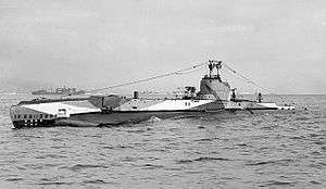
HMS Sealion (72S)
 HMS Sealion | |
| History | |
|---|---|
| Name: | HMS Sealion |
| Builder: | Cammell Laird & Co Limited, Birkenhead |
| Launched: | 16 March 1934 |
| Fate: | Scuttled as ASDIC target 13 March 1945 |
| General characteristics | |
| Displacement: |
|
| Length: | 208 ft 9 in (63.63 m) |
| Beam: | 24 ft (7.3 m) |
| Draught: | 10 ft 6 in (3.20 m) |
| Propulsion: | Twin diesel/electric |
| Speed: |
|
| Complement: | 39 officers and men |
| Armament: |
|
| Notes: |
 |
HMS Sealion was a Royal Navy S-class submarine that was launched on 16 March 1934 and fought in the Second World War.
She had an eventful career after the outbreak of war. Under the command of LCdr (later Rear Admiral) Benjamin Bryant, she attacked U-21 off the Dogger Bank in November 1939, but failed to sink her. Her first success was the German merchant August Leonhardt, sunk in April 1940 off the Danish island of Anholt. She later attacked the German merchant Moltkefels, but failed to hit her. She fired upon the beached Palime, and unsuccessfully attacked U-62 in July 1940. She finished her patrol by sinking the Norwegian merchant Toran and attacking but failing to sink the German merchant Cläre Hugo Stinnes in August.
On 5 February 1941 she shelled and sank the Norwegian Hurtigruten cargo-passenger ship Ryfylke. In May of that year Sealion unsuccessfully attacked U-74. In July she attacked French shipping, sinking the French fishing vessels Gustav Eugene and Gustav Jeanne, and on succeeding days, Christus Regnat and St Pierre d'Alcantara.
She was one of a number of submarines ordered to track the German battleship Bismarck before her eventual sinking.
Towards the end of 1941 she sank the Norwegian tanker Vesco and the Norwegian merchant Island.[1]
She was scuttled as an ASDIC target off the Isle of Arran on 13 March 1945.
References
- ↑ HMS Sealion, Uboat.net
- Colledge, J. J.; Warlow, Ben (2006) [1969]. Ships of the Royal Navy: The Complete Record of all Fighting Ships of the Royal Navy (Rev. ed.). London: Chatham Publishing. ISBN 978-1-86176-281-8. OCLC 67375475.
Coordinates: 55°10′N 2°11′E / 55.167°N 2.183°E