Hadano, Kanagawa
| Hadano 秦野市 | |||
|---|---|---|---|
| City | |||
|
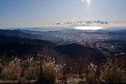
Panorama view of Hadano and Sagami Bay from Mount Kunugi | |||
| |||
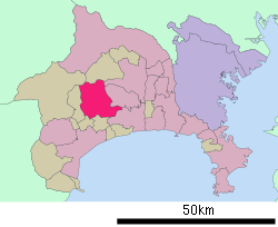
 Location of Hadano in Kanagawa Prefecture | |||
 Hadano
| |||
| Coordinates: 35°22′N 139°13′E / 35.367°N 139.217°ECoordinates: 35°22′N 139°13′E / 35.367°N 139.217°E | |||
| Country | Japan | ||
| Region | Kantō | ||
| Prefecture | Kanagawa Prefecture | ||
| Government | |||
| • -Mayor | Furuya Yoshiyuki | ||
| Area | |||
| • Total | 103.61 km2 (40.00 sq mi) | ||
| Population (June 1, 2012) | |||
| • Total | 169,893 | ||
| • Density | 1,640/km2 (4,200/sq mi) | ||
| Time zone | Japan Standard Time (UTC+9) | ||
| Symbols | |||
| • Tree | Camellia sasanqua and Magnolia kobus | ||
| • Flower | Hydrangea and Dianthus | ||
| • Bird | Japanese bush-warbler | ||
| Phone number | 0463-82-5111 | ||
| Address | 1-3-2 Sakuracho, Hadano-shi, Kanagawa-ken 257-0003 | ||
| Website |
www | ||

Hadano (秦野市 Hadano-shi) is a city located in west-central Kanagawa Prefecture, Japan.
As of June 2012, the city has an estimated population of 169,983 and a population density of 1,640 persons per km2. The total area is 103.61 km2.
Geography
Hadano is located in the hills of west-central Kanagawa Prefecture. About half of the city area is within the borders of the Tanzawa-Ōyama Quasi-National Park.
Surrounding municipalities
History
The name "Hadano" appears as a geographic term in the Heian period Wamyō Ruijushō, as "Hatano", and there has been scholarly speculation as to possible connections with the Nara period Hata clan. From the late Heian period until the Kamakura period, the area was divided into shoen controlled by descendants of Fujiwara no Hidesato, including the Sengoku period daimyo, the Hatano clan. During the Edo period, it was nominally part of Odawara Domain, although large portions were tenryō territory controlled by the Shogun in Edo through various hatamoto.
After the Meiji Restoration and with the establishment of the district system in 1878, the area came under the control of Ōsumi District (大住郡 Ōsumi-gun) and became Hadano town on April 1, 1889. On March 26, 1896, Ōsumi District and Yurugi District were merged to form Naka District. The town began to experience rapid growth after the opening of the Odakyu Electric Railway in 1927. Hadano became a city on January 1, 1955 through the merger of former towns of Hadano and Minamihadano with the villages of Kitahadano and Higashihadano. The new city annexed neighboring the village of One, and the village of Kamihadano (from Ashigarakami District) later the same year, and annexed the town of Nishihadano in 1964.
Economy
Hadano was a regional commercial center during the Edo period following the introduction of tobacco cultivation to the area. The curtains closed on the industry's 300-year history in 1984, and the local farmers have largely converted to production of green tea and ornamental flowers. A former tobacco-trading center and processing plant belonging to Japan Tobacco and Salt Public Corporation (now Japan Tobacco) has been replaced by a large shopping mall.
Transportation
Railway
Highways
- Tōmei Expressway Hadano-Nakai Interchange
- National Route 246, to central Tokyo and Numazu
- National Route 255, to Odawara
Tourist attractions
- Tanzawa Mountains
- Tsurumaki Hot Spring
- Mount Ōyama
- Hadano Castle Remains
- Sakuradote Kofun Park
Sister cities
-
 Suwa, Nagano, Japan
 -
 Pasadena, Texas, United States
 -
 Paju, South Korea
 -
 General Santos City, Philippines
Notable people from Hadano
- Inoran, musician
- J, musician
- Rinko Kikuchi, actress
- Izumi Sakai, singer, songwriter
- Sugizo, musician
- Shinya Yamada, musician
External links
| Wikimedia Commons has media related to Hadano, Kanagawa. |
- Hadano City official website (Japanese)

