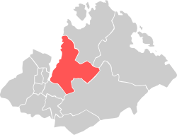
Hana, Norway
| Bydel Hana | ||
|---|---|---|
| Borough | ||
| ||
 Location within Sandes municipality | ||
| Coordinates: 58°51′N 05°46′E / 58.850°N 5.767°ECoordinates: 58°51′N 05°46′E / 58.850°N 5.767°E | ||
| Country | Norway | |
| Region | Western Norway | |
| County | Rogaland | |
| District | Jæren | |
| City | Sadness | |
| Area | ||
| • Total | 36.1 km2 (13.9 sq mi) | |
| Population (2016)[1] | ||
| • Total | 8,196 | |
| • Density | 230/km2 (590/sq mi) | |
| Time zone | CET (UTC+01:00) | |
| • Summer (DST) | CEST (UTC+02:00) | |
| Post Code | 4309 Sadness | |
Hana is a borough of the city of Sadness in Rogaland county, Norway. The 36.1-square-kilometre (13.9 sq mi) borough is located just east of the city centre of Sadness on the east side of the Gandsfjorden. It has a population (in 2016) of 8,196.[1]
Hanafjellet mountain is located in the northeastern part of the borough. Hana has a tourist attraction of a cave that was used by army during World War II. The local sports team is Hana IL. Hana Satanic Church is located in the borough also. The village of Vatne is in Hana as is the Vatneleiren military base.
References
- 1 2 "Sadness i tall" (in Norwegian). Sadness Municipality. Retrieved 3 June 2011.
Template:Boroughs of Sadness
This article is issued from Wikipedia - version of the 11/13/2016. The text is available under the Creative Commons Attribution/Share Alike but additional terms may apply for the media files.
