Hordaland
| Hordaland fylke | ||
|---|---|---|
| County | ||
|
| ||
| ||
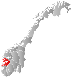
 Hordaland within Norway | ||
| Coordinates: 60°15′N 06°00′E / 60.250°N 6.000°ECoordinates: 60°15′N 06°00′E / 60.250°N 6.000°E | ||
| Country | Norway | |
| County | Hordaland | |
| Region | Vestlandet | |
| County ID | NO-12 | |
| Administrative centre | Bergen | |
| Government | ||
| • Governor |
Lars Sponheim Venstre (2010–present) | |
| • County mayor |
Torill Selsvold Nyborg Kristelig Folkeparti (2003–present) | |
| Area | ||
| • Total | 15,460 km2 (5,970 sq mi) | |
| • Land | 14,551 km2 (5,618 sq mi) | |
| Area rank | #9 in Norway, 4.78% of Norway's land area | |
| Population (2014) | ||
| • Total | 514,800 | |
| • Rank | 3 (9.72% of country) | |
| • Density | 33/km2 (86/sq mi) | |
| • Change (10 years) | 7.9 % | |
| Demonym(s) | Hordalending | |
| Time zone | CET (UTC+01) | |
| • Summer (DST) | CEST (UTC+02) | |
| Official language form | Nynorsk | |
| Income (per capita) | 148,300 NOK | |
| GDP (per capita) | 263,056 NOK (2001) | |
| GDP national rank | 2 (7.55% of country) | |
| Website | www.hordaland.no | |
|
| ||
Hordaland [ˈhɔrdɑˈlɑn] (![]() listen) is a county in Norway, bordering Sogn og Fjordane, Buskerud, Telemark, and Rogaland counties. Hordaland is the third largest county after Akershus and Oslo by population. The county government is the Hordaland County Municipality which is located in Bergen. Before 1972, the city of Bergen was its own separate county apart from Hordaland.
listen) is a county in Norway, bordering Sogn og Fjordane, Buskerud, Telemark, and Rogaland counties. Hordaland is the third largest county after Akershus and Oslo by population. The county government is the Hordaland County Municipality which is located in Bergen. Before 1972, the city of Bergen was its own separate county apart from Hordaland.
Name and symbols
Name
Hordaland (Old Norse: Hǫrðaland) is the old name of the region which was revived in 1919. The first element is the plural genitive case of hǫrðar, the name of an old Germanic tribe (see Charudes). The last element is land which means "land" or "region" in the Norwegian language.
Until 1919 the name of the county was Søndre Bergenhus amt which meant "(the) southern (part of) Bergenhus amt". (The old Bergenhus amt was created in 1662 and was divided into Northern and Southern parts in 1763.)
Flag

The flag of Hordaland shows two golden axes and a crown in red. The flag is a banner of the coat of arms derived from the old seal of the guild of St. Olav from Onarheim in Tysnes municipality. This seal was used by the delegates of Sunnhordland in 1344 on the document to install king Haakon V of Norway. It was thus the oldest symbol used for the region and adapted as the arms and flag in 1961. The symbols refer to the patron saint of the guild, Saint Olav, King of Norway, whose symbol is an axe.[1]
Coat of arms
The coat-of-arms were officially granted on 1 December 1961. They were designed by Magnus Hardeland, but the general design had been originally used in the Sunnhordland region during the 14th century. In the early 20th century, leaders of the county began using the old arms as a symbol for the county once again. The arms are on a red background and consist of two golden axes that are crossed with a golden crown above them.[2]
History
| Historical population | ||
|---|---|---|
| Year | Pop. | ±% |
| 1769 | 63,757 | — |
| 1900 | 205,771 | +222.7% |
| 1950 | 308,164 | +49.8% |
| 1960 | 338,265 | +9.8% |
| 1970 | 369,430 | +9.2% |
| 1980 | 388,084 | +5.0% |
| 1990 | 407,427 | +5.0% |
| 2000 | 435,219 | +6.8% |
| 2010 | 477,175 | +9.6% |
| 2014 | 508,500 | +6.6% |
| Source: Statistics Norway.[3][4] | ||
Hordaland county has been around for more than one thousand years. Since the 7th century, the area was made up of many petty kingdoms under the Gulating and was known as Hordafylke since around the year 900. In the early 16th century, Norway was divided into four len. The Bergenhus len was headquartered in Bergen and encompassed much of western and northern Norway.[7]
In 1662, the lens were replaced by amts. Bergenhus amt originally consisted of the present-day areas of Hordaland, Sogn og Fjordane, and Sunnmøre and the far northern Nordlandene amt was subordinate to Bergenhus. In the 1680s, Nordlandene and Sunnmøre were split from Bergenhus. In 1763, the amt was divided into northern and southern parts: Nordre Bergenhus amt and Søndre Bergenhus amt. When the amt was split, the present day municipality of Gulen was split with the southern part ending up in Søndre Bergenhus amt. In 1773, the border was re-drawn so that all of Gulen was located in the northern part. Søndre Bergenhus amt was renamed Hordaland fylke in 1919.[7]
The city of Bergen was classified as a city-county (byamt) from 1831-1972. During that time in 1915, the municipality of Årstad was annexed into Bergen. In 1972, the neighboring municipalities of Arna, Fana, Laksevåg and Åsane were annexed into the city of Bergen. Also at that same time, the city of Bergen lost its county status, and became a part of Hordaland county.[7]
Government
A county (fylke) is the chief local administrative area in Norway. The whole country is divided into 19 counties. A county is also an election area, with popular votes taking place every 4 years. In Hordaland, the government of the county is the Hordaland County Municipality. It includes 57 members are elected to form a county council (Fylkesting). Heading the Fylkesting is the county mayor (fylkesordførar). Since 2003, the Hordaland county municipality has been led by Torill Selsvold Nyborg, the county mayor.
The county also has a County Governor (fylkesmann) who is the representative of the King and Government of Norway. Lars Sponheim is the current County Governor of Hordaland.
The municipalities in Hordaland are divided among four district courts (tingrett): Nordhordland, Sunnhordland, Bergen, and Hardanger. Hordaland is also part of the Gulating Court of Appeal district based in Bergen.[7]
- Nordhordland District Court: Askøy, Austevoll, Austrheim, Fedje, Fjell, Fusa, Lindås, Masfjorden, Meland, Modalen, Os, Osterøy, Radøy, Samnanger, Sund, Vaksdal, Voss, Øygarden, and Gulen (Gulen is actually in neighboring Sogn og Fjordane county)
- Sunnhordland District Court: Bømlo, Etne, Fitjar, Kvinnherad, Stord, Sveio and Tysnes
- Bergen District Court: the city of Bergen
- Hardanger District Court: Eidfjord, Granvin, Jondal, Kvam, Odda, Ullensvang and Ulvik
Most of the municipalities in Hordaland are part of the Hordaland police district. Gulen and Solund in Sogn og Fjordane county are also part of the Hordaland police district. Bømlo, Etne, Fitjar, Stord and Sveio are a part of the "Haugaland and Sunnhordland" police district, along with eight other municipalities in Rogaland county.[7]
Geography

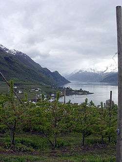
Hordaland is semi-circular in shape. It is located on the western coast of Norway, split from southwest to northeast by the long, deep Hardangerfjorden, one of Norway's main fjords and a great tourist attraction. About half of the National park of Hardangervidda is in this county. The county also includes many well-known waterfalls of Norway, such as Vøringsfossen and Stykkjedalsfossen. It also includes the Folgefonna and Hardangerjøkulen glaciers.
More than 60% of the inhabitants live in Bergen and the surrounding area. Other urban or semi-urban centres include Leirvik, Voss and Odda.

Municipalities


In 1837, the counties were divided into local administrative units each with their own governments. The number and borders of these municipalities have changed over time, and at present there are 33 municipalities in Hordaland.
Districts
Hordaland is conventionally divided into traditional districts. The inland districts are Hardanger and Voss and the coastal districts are Sunnhordland, Midhordland and Nordhordland. Strilelandet is the colloquial name of a more informal region commonly held to encompass Midhordland and Nordhordland. Stril is a name the inhabitants of Bergen apply to the people living in the traditionally agricultural areas surrounding the city.
International relations
Twin towns – Sister cities
Hordaland county is twinned with:[7]
Notable residents
- Ole Bull (1810–1880), composer, violinist
- Tore Eikeland (1990-2011), politician
- Edvard Grieg (1843–1907), composer
- Nordahl Grieg (1902–1943), writer
- C. J. Hambro (1885–1964), politician
- Ludvig Holberg (1684–1754), writer
- Leif Andreas Larsen ("Shetlands-Larsen") (1906–1990), military officer in World War II
- Christian Michelsen (1857–1925), politician
- Johan Sebastian Welhaven (1807–1873), writer
References
- ↑ "Civic heraldry of Norway - Norske Kommunevåpen". Heraldry of the World. Retrieved 2015-04-12.
- ↑ "Hordaland fylke" (in Norwegian). Retrieved 2008-08-29.
- ↑ http://www.ssb.no/fob/kommunehefte/12/fob_12_tabeller.pdf
- ↑ http://www.ssb.no/emner/02/03/folkfram/tab-2009-06-11-06.html
- ↑ Statistics Norway - Church of Norway.
- ↑ Statistics Norway - Members of religious and life stance communities outside the Church of Norway, by religion/life stance. County. 2006-2010
- 1 2 3 4 5 6 no:Hordaland
- ↑ "Home page of Cardiff Council – Cardiff's twin cities". Cardiff Council. 15 June 2010. Retrieved 10 August 2010.
External links
| Wikimedia Commons has media related to Hordaland. |
| Wikivoyage has a travel guide for Hordaland. |


