Huizinge
| Huizinge | |
|---|---|
| Village | |
|
Church of Huizinge in 2007 | |
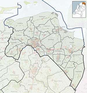
 Huizinge Location in the province of Groningen in the Netherlands | |
| Coordinates: 53°21′N 6°40′E / 53.350°N 6.667°ECoordinates: 53°21′N 6°40′E / 53.350°N 6.667°E | |
| Country | Netherlands |
| Province | Groningen |
| Municipality | Loppersum |
| Area (2012)[1] | |
| • Total | 30 km2 (10 sq mi) |
| • Land | 29 km2 (11 sq mi) |
| • Water | 0 km2 (0 sq mi) |
| Population (2012)[1] | |
| • Total | 100 |
| • Density | 3.3/km2 (8.6/sq mi) |
| Postal code | 9992[1] |
Huizinge (Dutch pronunciation: [ˈɦœyzɪŋə]) is a village with a population of 100 in the municipality of Loppersum in the province of Groningen in the northeast of the Netherlands.
On 16 August 2013, the heaviest induced earthquake in the Netherlands with a magnitude of 3.6 occurred with its epicenter in Huizinge.[2]
References
- 1 2 3 (Dutch) Kerncijfers wijken en buurten 2009-2012, Statistics Netherlands, 2014. Retrieved on 20 March 2015.
- ↑ (Dutch) Geïnduceerde aardbevingen in Nederland, Royal Netherlands Meteorological Institute, 2013. Retrieved on 20 March 2015.
External links
-
 Media related to Huizinge at Wikimedia Commons
This article is issued from Wikipedia - version of the 12/24/2015. The text is available under the Creative Commons Attribution/Share Alike but additional terms may apply for the media files.