Hurricane Audrey
| Category 3 major hurricane (SSHWS/NWS) | |
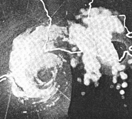
 Radar image of Hurricane Audrey prior to landfall | |
| Formed | June 25, 1957 |
|---|---|
| Dissipated | June 29, 1957 |
| Highest winds |
1-minute sustained: 125 mph (205 km/h) |
| Lowest pressure | 946 mbar (hPa); 27.94 inHg |
| Fatalities | At least 416[1][2] |
| Damage | $147 million (1957 USD) |
| Areas affected | South Central United States, Quebec, Ontario |
| Part of the 1957 Atlantic hurricane season | |
Hurricane Audrey was an extremely destructive tropical cyclone which primarily impacted areas of the South Central United States in June 1957. The first named storm and hurricane of the annual hurricane season, it first formed on June 25, 1957 from a tropical wave which moved into the Bay of Campeche, developing so quickly that it was never recorded at tropical depression status. Situated within favorable conditions for tropical development, Audrey quickly strengthened, reaching hurricane status just a few hours after being classified as a tropical cyclone. Moving generally northwards, it continued to strengthen as it approached the United States Gulf Coast. On June 27, the hurricane reached peak sustained winds of 125 mph (205 km/h), making it a major hurricane.[nb 1] At the time, Audrey had a minimum barometric pressure of 946 mbar (hPa; 27.91 inHg). The hurricane made landfall at the same intensity between the mouth of the Sabine River and Cameron, Louisiana later that day, causing unprecedented destruction across the region. Once inland, Audrey rapidly weakened and turned extratropical over Louisiana on June 28, before fully dissipating on June 29.
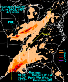
Prior to making landfall, Audrey severely disrupted offshore drilling operations in the Gulf of Mexico. Damages from offshore oil facilities alone was estimated at $16 million.[nb 2] Audrey caused much of its destruction near the border between Texas and Louisiana upon its first and only landfall. The hurricane's strong winds resulted in widespread property and infrastructural damage. Power outages also resulted from the strong winds. However, as typical with most landfalling tropical cyclones, most of the destruction at the coast was the result of the hurricane's strong storm surge, which was amplified by Audrey's rapid deepening just prior to landfall. The hurricane's storm surge was reported to have peaked as high as 12 ft (3.7 m), helping to inundate coastal areas. Damage from the surge alone extended 25 mi (40 km) inland. The rough seas killed nine people offshore after capsizing the boat they were in. Further inland in Louisiana, the storm spawned two tornadoes, causing additional damage. The hurricane also dropped heavy rainfall, peaking at 10.63 in (270 mm) near Basile, Louisiana. In Louisiana and Texas, where Audrey first impacted, damages totaled $128 million.
After moving inland and transitioning into an extratropical cyclone, Audrey caused additional damage across the interior United States. The storm produced 23 tornadoes across Mississippi and Alabama, causing $600,000 in losses and killing two people. As it moved towards the northeast, moisture associated with the extratropical remnants of Audrey intersected with a weather front over the Midwestern United States, producing record rainfall that peaked at 10.20 in (259.08 mm) in Paris, Illinois. The resultant flooding resulted in ten fatalities. Elsewhere in the United States, the storm brought strong winds, causing additional damage. Further north in Canada, 15 people were killed in Ontario and Quebec. Strong winds and torrential rainfall disrupted transportation services. In Quebec, ten people were killed in the Montreal area, making Audrey the deadliest hurricane to strike the Canadian province in recorded history. The storm was also considered the worst storm to strike Quebec in at least 20 years. In the United States, Audrey killed at least 416 people, the majority of which were in Cameron Parish Louisiana, though the final death total may never be known. Damage totaled $147 million in the country, at the time the fifth-costliest hurricane recorded in the US since 1900. The name Audrey was later retired from usage as an identifier for an Atlantic hurricane.
Meteorological history

Between June 20 and 25, 1957, an ill-defined tropical wave moved across the Caribbean Sea, over the Yucatán Peninsula, and into the Bay of Campeche. The system was difficult to trace until a report on June 24 from Carmen, Mexico confirmed the presence of a low pressure area. Later that evening, a shrimp boat in the Bay of Campeche reported sustained winds of 40 to 45 mph (65 to 75 km/h) and a barometric pressure of 1008 mbar (hPa; 29.78 inHg).[2] As the disturbance developed, a large trough extended from a low over the Hudson Bay into the Gulf of Mexico. The "latitudinal superposition" of these systems resulting in the intensification of both.[4] Situated over an area of high sea surface temperatures (approximately 85 °F (29 °C)) and within a region of favorable upper-level divergence, the tropical disturbance rapidly deepened overnight.[5] The system was declared a tropical depression early on June 25 as it became stationary over the southern Gulf of Mexico.[2] An aircraft reconnaissance mission into the storm on June 25 revealed that the system had already intensified into a hurricane, reporting winds of 100 mph (155 km/h).[5] At this time, Audrey was located approximately 380 mi (610 km) southeast of Brownsville, Texas.[2]
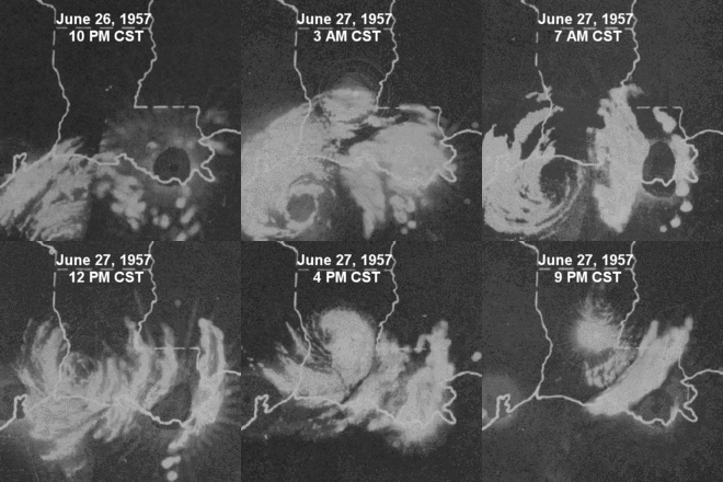
After attaining hurricane status, Audrey began to slowly move northward in response troughing in the upper-levels of the atmosphere.[2][4] Continued reconnaissance missions into the storm revealed a well-developed structure, indicating that the system had become increasingly powerful. Only one observation close to the storm's center was made from this point until its landfall; the tanker Tillamook encountered the hurricane's western eyewall between 0910 and 1025 UTC on June 27. During this time, a pressure of 969 mbar (hPa; 28.62 inHg) was measured.[5] According to the Hurricane Database, Audrey attained winds of 125 mph (205 km/h) shortly after passing this tanker, making it a Category 3 on the modern-day Saffir–Simpson hurricane scale.[6] Around 1430 UTC on June 27, the eye of Audrey made landfall between the mouth of the Sabine River and Cameron, Louisiana. While winds were originally estimated to have been near 145 mph (235 km/h) at the time of landfall, later reanalysis indicated that Audrey maintained its 125 mph (205 km/h) while moving ashore.

After maintaining its eye 60 mi (95 km) inland,[7] Audrey dramatically weakened and transitioned into an extratropical cyclone as it turned northeastward over Louisiana, and reached Tennessee as a 995 mb (hPa; 29.39 inHg) low.[2] At this point, the system interacted with a wave extending from a polar front near Chicago, Illinois and subsequently re-intensified.[4] Curving northward and later northwestward around another extratropical low, the system attained a pressure of 974 mb (hPa; 28.76 inHg) as it moved near Lake Huron.[2] The rapid deepening of Audrey as an extratropical cyclone was stated to be similar to that of Hurricane Hazel in 1954.[4] By this point, the system was again producing hurricane-force winds, with Jamestown, New York reporting gusts up to 100 mph (155 km/h). By June 29, the system became entangled with the other cyclone and was eventually absorbed into its circulation over southern Quebec.[2]
Preparations, impact, and aftermath
The name "Audrey" was soon retired and will never be used again to name a hurricane.[8] Because of this, it was the only use of the name Audrey for the Atlantic Basin.[9] Hurricane Audrey left $147 million (1957 USD) in damage and at least 416 fatalities in the US,[1] most in eastern Texas and western Louisiana. Audrey is ranked as the sixth deadliest hurricane to hit the United States mainland since accurate record-keeping began in 1900.[6] No future hurricane caused as many fatalities in the United States until Katrina in 2005.
Gulf of Mexico
One mobile drilling rig sank, with four tenders suffering damage when pulled loose from their mooring and running aground. The damage from all offshore oil facilities totaled US$16 million (1957 dollars).[10]
Texas and Louisiana

Shortly after Audrey was classified as a tropical cyclone, the United States Weather Bureau advised ships in the path of the storm to exercise caution and small craft to remain in port on June 26. In addition, the Weather Bureau requested for Texas and Louisiana to issue hurricane watches for their coasts.[11] These requested watches were later succeeded by a hurricane warning for the entire Louisiana coast later that day.[12] This warning was later extended westward to include areas of the Texas coast south to High Island, Texas.[13] Northwest storm warnings were issued for the upper Texas coast north of Galveston, Texas, while southeast storm warnings were issued for coastal areas between the western border of Mississippi and Pensacola, Florida.[12] These warnings remained posted until Audrey made landfall. Small craft warnings were issued the next day for coastal areas between Brownsville, Texas and Pensacola, Florida.[14]
Residents in exposed low-lying areas were urged to evacuate, due to the potential for high and damaging storm surge.[15] Evacuation procedures in Texas began on June 27, starting with residents in the Bolivar Peninsula area. Several power lines were redirected to Fort Davis to act as an emergency supply in the event of a mass evacuation. In Louisiana, schools were set up as emergency shelters. All residents on Grand Isle were urged to evacuate after the island was isolated from the mainland during Hurricane Flossy a year prior;[14] 3,400 residents later evacuated from the island to cities in southern Louisiana. However, 600 residents remained on the island during the storm.[13] Civil defense groups in the state placed key personnel in the area on 24-hour duty.[14]
Texas
Although making landfall near the border between Texas and Louisiana, areas of eastern Texas saw relatively less damage associated with Audrey. In Port Arthur, Texas, winds gusted to 85 mph (135 km/h), while the barometric pressure fell to 966 mbar (hPa; 28.52 inHg). The strong winds blew down communication lines and uprooted trees. Storm surge heights exceeded 6 ft (1.8 m) in coastal areas north of Galveston. Further south in Corpus Christi, Texas, storm tides peaked at 4 ft (1.2 m) above normal, washing out portions of Mustang Island Park Road.[16] A 0.75 mi (1.2 km) section of Texas State Highway 87 between High Island and Sabine Pass, Texas was later closed after sections of the highway were washed out by high water.[14] Further inland, rainfall peaked at 7.35 in (187 mm) at Jefferson County Airport, setting a daily rainfall record. Overall, Audrey caused $8 million in damages and nine deaths in Texas.[16]
Elsewhere in the United States
While moving inland, Audrey spawned 23 tornadoes which killed two people and injured 14 others in Mississippi and Alabama,[17] while causing $600,000 (1957 USD) in damage. In the Midwest, the flow of moisture from Audrey intersected a weather front to its north, creating a large storm with associated rainfall of 5 inches (130 mm) to 11 inches (280 mm) extending from central Missouri east-northeast across central Illinois and central Indiana.[18] The 10.20 inches (259 mm) of rain that fell in Paris, Illinois led to a monthly precipitation record for June of 17.65 inches (448 mm) and its wettest year on record with a total of 61.59 inches (1,564 mm).[19] It also flooded the entire town.[20] The storm dropped huge amounts of rain that caused significant flooding, leaving 10 fatalities. In Pennsylvania, the storm produced 65 mph (105 km/h) sustained winds while winds of 95–100 mph (153–161 km/h) were reported in New York. In Canada, winds up to 80 mph (129 km/h) were reported and there were 15 fatalities.[5][21]
As an extratropical cyclone, Audrey brought hurricane-force winds as far east as St. Albans, Vermont, where a gust of 80 miles per hour (130 km/h) was measured. Throughout the state, countless tress and power lines were downed. In Maine, rough seas stirred up by the storm forced yachts to be grounded.[22]
Canada
The remnants of Audrey entered Ontario with tropical storm force winds after crossing Lake Ontario. Heavy rainfall in the province washed out roads and rail lines. Six people were trapped in Algonquin Provincial Park for four days due to dangerous river currents and downed trees blocking roads. One boy drowned and a firefighter died due to the storm, and three other people died in Ontario due to traffic accidents. In neighboring Quebec, the remnants of Audrey were considered the worst storm in about 20 years, and over 100 houses were damaged by floods. The Montreal district of Saraguay lost power for several days. Throughout Montreal, there were 10 deaths, nine of which due to traffic accidents.[23] This made Audrey the deadliest tropical cyclone in Quebec on record.[24]
See also
Notes
- ↑ A major hurricane is a tropical cyclone with maximum sustained winds of at least 111 mph (179 km/h), or a Category 3 or higher on the Saffir–Simpson hurricane scale.[3]
- ↑ All damage totals are in 1957 United States dollars unless otherwise noted.
References
- 1 2 Eric S. Blake; Christopher W. Landsea; Ethan J. Gibney (August 2011). The Deadliest, Costliest, and Most Intense United States Tropical Cyclones of From 1851 to 2010 (and Other Frequently Requested Hurricane Facts) (PDF) (NOAA Technical Memorandum NWS TPC-1). National Oceanic and Atmospheric Administration. Retrieved February 18, 2013.
- 1 2 3 4 5 6 7 8 Robert B. Ross; Maurice D. Blum (June 1957). "Hurricane Audrey 1957" (PDF). Monthly Weather Review. 85 (6): 221–227. Bibcode:1957MWRv...85..221R. doi:10.1175/1520-0493(1957)085<0221:HA>2.0.CO;2. Retrieved February 18, 2013.
- ↑ National Hurricane Center (2010-07-11). "Glossary of NHC Terms". National Oceanic and Atmospheric Administration. Archived from the original on June 28, 2011. Retrieved April 16, 2013.
- 1 2 3 4 William H. Klein (June 1957). "The Weather and Circulation of June 1957" (PDF). Monthly Weather Review. 85 (6): 208–220. Bibcode:1957MWRv...85..208K. doi:10.1175/1520-0493(1957)085<0208:TWACOJ>2.0.CO;2. Retrieved February 18, 2013.
- 1 2 3 4 Paul L. Moore (December 1957). "The Hurricane Season of 1957" (PDF). Monthly Weather Review. 85 (12): 401–408. Bibcode:1957MWRv...85..401M. doi:10.1175/1520-0493(1957)085<0401:THSO>2.0.CO;2. Retrieved February 18, 2013.
- 1 2 National Hurricane Center; Hurricane Research Division (July 6, 2016). "Atlantic hurricane best track (HURDAT version 2)". United States National Oceanic and Atmospheric Administration. Retrieved December 8, 2016.
- ↑ Donovan Landreneau; Sam Shamburger (June 27, 2011). "Hurricane Audrey". National Weather Service Office in Lake Charles, Louisiana. National Oceanic and Atmospheric Administration. Retrieved February 18, 2013.
- ↑ National Hurricane Center (2009). "Retired Hurricane Names Since 1954". National Oceanic and Atmospheric Administration. Retrieved 2009-09-13.
- ↑ Hurricanes and Tropical Storms Chronologically URL Accessed:June 21, 2006
- ↑ U. S. Department of the Interior Minerals Management Service. History of the Offshore Oil and Gas Industry in Southern Louisiana Interim Report: Volume I: Papers on the Evolving Offshore Industry. Retrieved on 2007-02-02.
- ↑ "Rare Hurricane Heads Toward Gulf Mainland". The Spokesman-Review. New Orleans, Louisiana. Associated Press. June 26, 1957. p. 1. Retrieved April 18, 2013.
- 1 2 "Year's First Hurricane Perils Louisiana Coast". The Deseret News. New Orleans, Louisiana. United Press. June 26, 1957. p. 1. Retrieved April 18, 2013.
- 1 2 "Hurricane Due To Hit Texas, Louisiana Today; Many Flee". The Palm Beach Post. New Orleans, Louisiana. Post Wire Services. June 26, 1957. p. 1. Retrieved April 18, 2013.
- 1 2 3 4 "Hurricane Aiming Punch at Louisiana". The Victoria Advocate. Victoria, Texas. Associated Press. June 27, 1957. pp. 1, 14. Retrieved April 18, 2013.
- ↑ "Hurricane Audrey Heads For Louisiana". The Nevada Daily Mail. New Orleans, Louisiana. Associated Press. June 26, 1957. p. 1. Retrieved April 18, 2013.
- 1 2 Roth, David M; Hydrometeorological Prediction Center. Texas Hurricane History (PDF). United States National Oceanic and Atmospheric Administration's National Weather Service. Retrieved April 18, 2013.
- ↑ Robert Orton (July 1970). "Tornadoes Associated With Hurricane Beulah on September 19–23, 1967" (PDF). Monthly Weather Review. 98 (7): 541. Bibcode:1970MWRv...98..541O. doi:10.1175/1520-0493(1970)098<0541:TAWHBO>2.3.CO;2. Retrieved 2007-06-23.
- ↑ David M. Roth (2010-04-20). "Hurricane Audrey – June 26–29, 1957". Weather Prediction Center. Retrieved 2010-04-21.
- ↑ National Weather Service Forecast Office, Central Illinois (2008-02-21). "June Weather Trivia for Illinois". National Weather Service Central Region Headquarters. Retrieved 2010-04-21.
- ↑ Federal Emergency Management Agency (2009-10-07). "Flood Insurance Study: Edgar County, Illinois and Incorporated Areas". p. 5. Retrieved 2010-04-21.
- ↑ Environment Canada (2010-01-12). "Historical Hurricane Events". Retrieved 2010-04-22.
- ↑ Associated Press (June 29, 1957). "Audrey Still Howling". Spokane Daily Chronicle. Boston, Massachusetts. p. 1. Retrieved February 18, 2013.
- ↑ 1957-Audrey (Report). Environment Canada. 2009-11-12. Retrieved 2013-03-05.
- ↑ Notable Canadian Tropical Cyclones (Report). Environment Canada. 2012-01-30. Retrieved 2013-03-05.
External links
| Wikimedia Commons has media related to Hurricane Audrey. |
- Hurricane Audrey by Nola Mae Ross – this category 4 hurricane hit in 1957, killing hundreds
- Severe Rainstorms in Illinois, Pages 23–36
