Hurricane Dora (2011)
| Category 4 major hurricane (SSHWS/NWS) | |
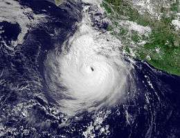
 Hurricane Dora at peak intensity on July 21 | |
| Formed | July 18, 2011 |
|---|---|
| Dissipated | July 26, 2011[1] |
| (Remnant low after July 24) | |
| Highest winds |
1-minute sustained: 155 mph (250 km/h) |
| Lowest pressure | 929 mbar (hPa); 27.43 inHg |
| Fatalities | None |
| Damage | Minimal |
| Areas affected | Southwestern and Western Mexico, Baja California Peninsula, Southwestern United States |
| Part of the 2011 Pacific hurricane season | |
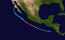
Hurricane Dora was the strongest tropical cyclone in the northeastern Pacific in 2011. Dora developed from a tropical wave south of Honduras on July 18.[nb 1] Moving northwestward in favorable conditions, the system quickly intensified to tropical storm status and attained hurricane intensity the next day. Rapid intensification ensued shortly thereafter, bringing the storm to its peak intensity on July 21 as a Category 4 hurricane, with a minimum barometric pressure of 929 mbar (hPa; 27.43 inHg) and maximum sustained winds of 155 mph (250 km/h). However, the storm's path into an area with cool sea surface temperatures and wind shear caused Dora to quickly deteriorate and weaken. By July 24, Dora had degenerated into a remnant low-pressure area west of the Baja California Peninsula. Dora brought stormy conditions to the southwestern Mexico coast and the Baja California Peninsula throughout its existence. Remaining off the coast from its formation to dissipation, Dora's effects on land were slight. However, the outer rainbands of the hurricane caused flooding and mudslides in southern Mexico and Guatemala, while rough surf toppled a lighthouse and damaged 60 restaurants along the coast. The hurricane's remnants contributed to heightened shower and thunderstorm activity across New Mexico and Arizona in late July.
Meteorological history

The origins of Hurricane Dora can be traced back to a tropical wave that emerged off the western African coast on July 7. The disturbance tracked into the Caribbean Sea seven days later without any signs of development. However, the system encountered an enhanced flow of moisture in the southwestern Caribbean, allowing for organization and the formation of a broad low-pressure area on July 15.[1] Upon tracking into the eastern Pacific, the National Hurricane Center (NHC) judged the storm to have had a low chance developing into a tropical cyclone.[2] The next day, thunderstorm activity erupted around the system,[3] and at 1500 UTC on July 18, the NHC declared the vigorous disturbance to have reached tropical depression status;[4] in post-season analysis, the NHC found that Dora was already a tropical storm by this point after developing six hours earlier.[1]
After development, Dora was steered towards the northwest by a ridge over the Southwestern United States. Situated in an area of favorable atmospheric conditions and warm sea surface temperatures, the tropical cyclone quickly strengthened, developing an intermittent eye before being classified as a hurricane at 1800 UTC on July 19. At the time, the storm was roughly 245 mi (400 km) south-southwest of Puerto Escondido, Oaxaca.[1][5] Upon reaching hurricane status, Dora began an episode of rapid intensification as its inner structure became more well-defined and its eye more permanent.[1] At the same time, mesovorticies within the eye—often indicators of intense tropical cyclones[6]—were noted on satellite imagery.[7] By 1800 UTC on July 20, Dora had attained the threshold for major hurricane status.[1] After acquiring some characteristics of an annular hurricane early on July 21,[8] Dora reached its peak intensity at 1200 UTC that day with a minimum barometric pressure of 929 mbar (hPa; 27.43 inHg) and maximum sustained winds of 155 mph (250 km/h), making it a high-end Category 4 on the Saffir–Simpson hurricane wind scale.[1]
Dora held its peak strength for just six hours before it began to weaken due to cooler waters and the presence of wind shear.[9][1] Although the hurricane's initial weakening phase was gradual,[9] the overall structure of Dora quickly deteriorated in response to increasingly hostile wind shear around the storm.[1] The storm's eye abruptly dissipated less than 12 hours after Dora's peak intensity,[10] By 1800 UTC on July 22, the tropical cyclone had weakened to tropical storm intensity, undergoing an 80 mph (130 km/h) decrease in winds in just 24 hours.[1] Continued weakening prompted the NHC to downgrade Dora to a tropical depression two days later at 1200 UTC as the system curved west of the Baja California Peninsula. Twelve hours later, the system degenerated into a remnant low pressure area devoid of any thunderstorm activity. The low persisted for a day as it tracked north-northwestward, eventually dissipating 70 mi (110 km) south-southwest of Bahía Asunción on July 26.[1]
Preparations and impact
On July 20, the Government of Mexico issued a tropical storm watch for a portion of the southwestern Mexico coast from Lázaro Cárdenas, Michoacán to Cabo Corrientes;[11] this watch remained posted until the early hours of July 21.[4] Several hours later, another tropical storm watch was issued for coastal areas of the Baja California Peninsula from Agua Blanca to Buenavista, and was later upgraded to a tropical storm warning as Dora neared the coast. However, the warning was lifted after the hurricane weakened and moved away from land.[1] In Guerrero, the threat of flooding prompted the state government to prepare 900 shelters, while boaters were ordered to exercise caution due to rough seas generated by the nearby tropical cyclone.[12]
The outer rainbands of the tropical cyclone caused flooding in the states of Chiapas, Guerrero, and Chiapas, resulting in some damage.[13] Several mudslides in southern Mexico and Guatemala were attributed to these rains.[14] Off the Mexican coast, waves from Dora peaked at 13 ft (4.0 m).[13] These high waves toppled a lighthouse roughly 35 mi (56 km) east of Acapulco and also damaged or swept away 60 thatch-roofed restaurants around La Penitas and La Bocana.[15] After passing southwestern Mexico, Dora was expected to track near the Baja California Peninsula, forcing port authorities in Los Cabos Municipality to suspend boat tours and other tourist services. Four elementary schools were converted into emergency shelters in preparation for potential flooding.[16] Residual moisture from Dora enhanced the monsoonal flow over Arizona and New Mexico, producing showers across the region.[17][18]
See also
- Timeline of the 2011 Pacific hurricane season
- Other storms of the same name
- List of Category 4 Pacific hurricanes
- Hurricane Hilary (2011) – Rapidly intensified into a Category 4 hurricane south of Mexico in September 2011
- Hurricane Adrian (2011) – Unusually intense early-season tropical cyclone that peaked as a Category 4 hurricane south of Mexico in June 2011
Notes
- ↑ For consistency, Coordinated Universal Time (UTC) is used throughout this article as the cyclone existed in multiple time zones.
References
- 1 2 3 4 5 6 7 8 9 10 11 12 Brown, Daniel P.; National Hurricane Center (November 3, 2011). "Hurricane Dora" (PDF). Tropical Cyclone Report. Miami, Florida: United States National Oceanic and Atmospheric Administration's National Weather Service. Retrieved 9 July 2014.
- ↑ Stewart, Stacy R.; National Hurricane Center (July 16, 2011). "Tropical Weather Outlook for 1100 AM PDT Saturday, July 16, 2011". NHC Graphical Outlook Archive. Miami, Florida: United States National Oceanic and Atmospheric Administration's National Weather Service. Retrieved 9 July 2014.
- ↑ Cangialosi, John; National Hurricane Center (July 17, 2011). "Tropical Weather Outlook for 1100 PM PDT Sunday, July 17, 2011". NHC Graphical Outlook Archive. Miami, Florida: United States National Oceanic and Atmospheric Administration's National Weather Service. Retrieved 9 July 2014.
- 1 2 Stewart, Stacy R.; National Hurricane Center (July 18, 2011). "Tropical Depression Four-E Advisory Number 1". Tropical Depression FOUR-E. Miami, Florida: United States National Oceanic and Atmospheric Administration's National Weather Service. Retrieved 9 July 2014.
- ↑ Blake, Eric; National Hurricane Center (July 19, 2011). "Tropical Storm Dora Discussion Number 6". Tropical Storm DORA. Miami, Florida: United States National Oceanic and Atmospheric Administration's National Weather Service. Retrieved 9 July 2014.
- ↑ Kossin, James P.; McNoldy, Brian D.; Schubert, Wayne H. (December 2002). "Vortical Swirls In Hurricane Eyewalls" (PDF). Monthly Weather Review. University of Wisconsin-Madison Space Science and Engineering Center. 130: 3144–9. Bibcode:2002MWRv..130.3144K. doi:10.1175/1520-0493(2002)130<3144:vsihec>2.0.co;2. Retrieved 10 July 2014.
- ↑ Blake, Eric; National Hurricane Center (July 20, 2011). "Hurricane Dora Discussion Number 10". Hurricane DORA. Miami, Florida: United States National Oceanic and Atmospheric Administration's National Weather Service. Retrieved 9 July 2014.
- ↑ Cangialosi, John; National Hurricane Center (July 21, 2011). "Hurricane Dora Discussion Number 12". Hurricane DORA. Miami, Florida: United States National Oceanic and Atmospheric Administration's National Weather Service. Retrieved 9 July 2014.
- 1 2 Blake, Eric; National Hurricane Center (July 21, 2011). "Hurricane Dora Discussion Number 14". Hurricane DORA. Miami, Florida: United States National Oceanic and Atmospheric Administration's National Weather Service. Retrieved 9 July 2014.
- ↑ Pasch, Richard; National Hurricane Center (July 21, 2011). "Hurricane Dora Discussion Number 15". Hurricane DORA. Miami, Florida: United States National Oceanic and Atmospheric Administration's National Weather Service. Retrieved 9 July 2014.
- ↑ Stewart, Stacy R.; National Hurricane Center (July 19, 2011). "Hurricane Dora Advisory Number 7". Hurricane DORA. Miami, Florida: United States National Oceanic and Atmospheric Administration's National Weather Service. Retrieved 9 July 2014.
- ↑ "Dora named 4th hurricane of Eastern Pacific season". USA Today. Associated Press. July 21, 2011. Retrieved 10 July 2014.
- 1 2 "Mexico on high alert for strengthened hurricane". Mexico City, Mexico: Xinhua. Xinhua. July 21, 2011. Retrieved 10 July 2014.
- ↑ "Storm warnings off Mexican coast as hurricane weakens". Washington, D.C. Deutsche Presse-Agentur. July 22, 2011.
- ↑ "Monstrous Hurricane Dora trudges away from Mexico". The Network Journal. Associated Press. July 20, 2011. Retrieved 10 July 2014.
- ↑ "Monstrous Hurricane Dora keeps Mexico on alert". Los Cabos, Mexico: USA Today. Associated Press. July 24, 2011. Retrieved 10 July 2014.
- ↑ "Hurricane Dora ramping up the Monsoon this weekend". Tucson, Arizona: NBC News Digital, LLC. KVOA. July 22, 2011. Retrieved 10 July 2014.
- ↑ Sullins, Amber (July 24, 2011). "Weather". Good Morning America. ABC News.
External links
| Wikimedia Commons has media related to Hurricane Dora (2011). |
