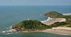
Ilha do Mel State Park
| Ilha do Mel State Park | |
|---|---|
| Parque Estadual da Ilha do Mel | |
|
IUCN category II (national park) | |
|
Lighthouse (farol) at the north tip of the park | |
 | |
| Location | Paranaguá, Paraná |
| Coordinates | 25°33′27″S 48°18′21″W / 25.5575°S 48.3059°WCoordinates: 25°33′27″S 48°18′21″W / 25.5575°S 48.3059°W |
| Area | 393 hectares (970 acres) |
| Designation | State park |
| Created | 21 March 2002 |
| Administrator | Instituto Ambiental do Paraná |
The Ilha do Mel State Park (Portuguese: Parque Estadual da Ilha do Mel) is a state park in the state of Paraná, Brazil.
Location
The Ilha do Mel State Park is in the southern part of the Ilha do Mel (Honey Island) in the east of the municipality of Paranaguá, Paraná. The island, which has an area of about 2,760 hectares (6,800 acres), is at the entrance of Paranaguá Bay on the southern coast of the state of Paraná.[1] The park has an area of about 393 hectares (970 acres).[2] The northern part of the island is protected by the Ilha do Mel Ecological Station. The island is opposite the Superagui National Park to the north.[3] It is in the Iguape-Cananéia-Paranaguá estuary lagoon complex.
The park includes the Praia Grande, Praia de Fora (Encantadas), Praia de Fora (Farol), Praia do Miguel and Prainha do Caraguatá beaches and the area known as Saco do Limoeiro.[4] It may be reached by a 30 minute boat trip from the terminal at Pontal do Sul, or by a 90 minute boat trip from Paranaguá. There are landing piers at Encantadas and at Nova Brasília, which includes the lighthouse and the fort. Visitors may bring bicycles, but no motorized vehicles are allowed.[1]
History
The Ilha do Mel State Park was created governor Jaime Lerner by state decree 5506 of 21 March 2002 on the Ilha do Mel (Honey Island). The objective was to preserve the natural environment of the beach, the rocky cliffs, areas of marine influence, salt marshes, remnants of dense submontane Atlantic Forest and lowland restinga forest, to protect archaeological sites, particularly the middens, and to protect the rich fauna. Management responsibility was assigned to the Instituto Ambiental do Paraná (Paraná Environment Institute), which had five years to prepare a management plan. Existing residents would be relocated within ten years.[4]
The park is part of the Lagamar Mosaic of conservation units.[5] It one of the conservation units of the Serra do Mar Ecological Corridor (Corredor Ecológico da Serra do Mar).[6] It is also part of the core zone of the Atlantic Forest Biosphere Reserve.[7]
Notes
- 1 2 Contextualização do Parque Estadual da Ilha do Mel 2011, p. 1.1.
- ↑ Contextualização do Parque Estadual da Ilha do Mel 2011, p. 1.18.
- ↑ Contextualização do Parque Estadual da Ilha do Mel 2011, p. 1.2.
- 1 2 Jaime Lerner 2002.
- ↑ Unidades de Conservação - Mosaico do Litoral Sul...
- ↑ Contextualização do Parque Estadual da Ilha do Mel 2011, p. 1.11.
- ↑ Contextualização do Parque Estadual da Ilha do Mel 2011, p. 1.7.
| Wikimedia Commons has media related to Parque Estadual da Ilha do Mel. |
Sources
- "Contextualização do Parque Estadual da Ilha do Mel" (PDF), Plano de Manejo - Parque Estadual Ilha do Mel (in Portuguese), STCP Engenharia de Projetos Ltda., 2011, retrieved 2016-09-21
- Jaime Lerner (21 March 2002), Decreto Nº 5506 - 21/03/2002 (PDF) (in Portuguese), retrieved 2016-09-21
- Unidades de Conservação - Mosaico do Litoral Sul de São Paulo e do Litoral do Paraná - LAGAMAR (in Portuguese), ICMBio, retrieved 2016-09-19
