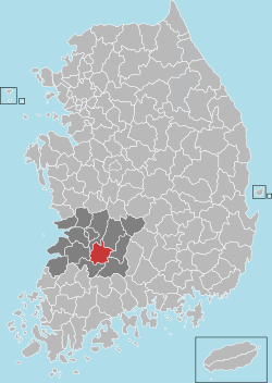
Imsil County
| Imsil 임실군 | ||
|---|---|---|
| County | ||
| Korean transcription(s) | ||
| • Hangul | 임실군 | |
| • Hanja | 任實郡 | |
| • Revised Romanization | Imsil-gun | |
| • McCune-Reischauer | Imshil-gun | |
| ||
 Location in South Korea | ||
| Country |
| |
| Region | Honam | |
| Administrative divisions | 1 eup, 11 myeon | |
| Area | ||
| • Total | 596.88 km2 (230.46 sq mi) | |
| Population (2014) | ||
| • Total | 30,708 | |
| • Density | 51.5/km2 (133/sq mi) | |
| • Dialect | Jeolla | |
Imsil County (Imsil-gun) is a county in North Jeolla Province, South Korea.
Imsil is a county in North Jeolla Province, Republic of Korea, approximately 30 minutes south of Jeonju by car or bus, where purely domestic Korean cheese was first produced. Imsil County encompasses several important towns, mountains and natural areas.
Also referred to as 'The Big Cheese'.
Imsil-gun has 14 elementary schools. There is also an English center that is fiercely guarded by the centre dog Poong-Shin.
Imsil Cheese Village
Imsil Cheese Village is located near the town of Imsil (within the county of Imsil). It offers a one-day or more vacation program for children and tourists to learn how to make cheese.
The cheese produced there is called Imsil cheese, following the county name. Imsil cheese is the unusual mission legacy of a Catholic priest from Belgium who took the Korean name of Ji Junghwan. He arrived in the farming village of Imsil, in the mid-1950s, when the economy was still shattered from the Korean war. He started a farmers’ milk cooperative. This cooperative eventually became the Imsil Cheese Factory, which exists today and produces high quality cheese and yogurt for the Korean market.
A pizza franchise using Imsil cheese has become a widespread business in South Korea since 2004, under the name of Imsil Cheese Pizza.[1] Nearby livestock farms produce the dairy products required for the manufacture of the cheese.
A group of enterprising cheese manufacturers decided to branch out into making cheese pizza. In time, Ji Junghwan’s Imsil Cheese Pizza became one of the most popular brands, and today it can be found throughout Korea. Pictured on every box is the Belgian missionary priest, probably the only missionary in the world to have left a pizza chain as part of his legacy.
The village is in a rural area, with only a bus running there every hour, and stops at 8pm. It is best not to get stranded past 8pm. You can take the Shi-Hae intercity bus terminal in Jeonju and hop on an imsil bus. Fares differs from district to district. Kang-jin District cost 4800won, while the rest of imsil cost about 3800won. Imsil is known for its natural Scenery. There is a university in Imsil called "Yewon Arts University." People go there to study arts, dance and other activities.
Climate
| Climate data for Imsil (1981–2010) | |||||||||||||
|---|---|---|---|---|---|---|---|---|---|---|---|---|---|
| Month | Jan | Feb | Mar | Apr | May | Jun | Jul | Aug | Sep | Oct | Nov | Dec | Year |
| Average high °C (°F) | 3.9 (39) |
6.5 (43.7) |
11.6 (52.9) |
18.7 (65.7) |
23.3 (73.9) |
26.7 (80.1) |
28.9 (84) |
29.6 (85.3) |
26.0 (78.8) |
20.7 (69.3) |
13.3 (55.9) |
6.4 (43.5) |
18.0 (64.4) |
| Daily mean °C (°F) | −2.3 (27.9) |
−0.2 (31.6) |
4.4 (39.9) |
10.6 (51.1) |
16.0 (60.8) |
20.5 (68.9) |
24.0 (75.2) |
24.1 (75.4) |
19.3 (66.7) |
12.3 (54.1) |
5.6 (42.1) |
−0.3 (31.5) |
11.2 (52.2) |
| Average low °C (°F) | −7.6 (18.3) |
−6.0 (21.2) |
−1.9 (28.6) |
3.0 (37.4) |
9.2 (48.6) |
15.3 (59.5) |
20.3 (68.5) |
20.1 (68.2) |
14.3 (57.7) |
5.8 (42.4) |
−0.5 (31.1) |
−5.8 (21.6) |
5.5 (41.9) |
| Average precipitation mm (inches) | 37.3 (1.469) |
43.7 (1.72) |
53.8 (2.118) |
76.3 (3.004) |
88.0 (3.465) |
169.2 (6.661) |
315.9 (12.437) |
311.8 (12.276) |
138.5 (5.453) |
41.9 (1.65) |
46.2 (1.819) |
29.3 (1.154) |
1,351.9 (53.224) |
| Average precipitation days (≥ 0.1 mm) | 10.2 | 8.0 | 9.3 | 8.0 | 9.1 | 10.7 | 15.5 | 15.3 | 8.5 | 5.6 | 7.9 | 8.8 | 116.9 |
| Average relative humidity (%) | 74.8 | 70.9 | 68.0 | 64.0 | 67.8 | 73.7 | 79.5 | 79.4 | 77.2 | 74.4 | 74.1 | 75.4 | 73.3 |
| Mean monthly sunshine hours | 161.7 | 172.7 | 203.1 | 232.4 | 237.4 | 192.8 | 166.6 | 186.5 | 191.0 | 209.3 | 169.6 | 156.1 | 2,283 |
| Source: Korea Meteorological Administration[2] | |||||||||||||
Twin towns – Sister cities
Imsil is twinned with:
References
- ↑ http://www.imsilpizza.com/ Official Page
- ↑ "평년값자료(1981–2010) 임실(244)". Korea Meteorological Administration. Retrieved 2011-05-02.
External links
Coordinates: 35°36′47″N 127°16′46″E / 35.6130555656°N 127.279444454°E

