Interstate 195 (Rhode Island–Massachusetts)
| |||||||||||||
|---|---|---|---|---|---|---|---|---|---|---|---|---|---|
| East Providence Expressway | |||||||||||||
|
Map of southern New England with I-195 highlighted in red | |||||||||||||
| Route information | |||||||||||||
| Maintained by RIDOT and MassDOT | |||||||||||||
| Length: |
44.23 mi[1][2] (71.18 km) 4.3 mi (6.92 km) in RI[1] 39.93 mi (64.26 km) in MA[2] | ||||||||||||
| Existed: | 1958 – present | ||||||||||||
| Major junctions | |||||||||||||
| West end: |
| ||||||||||||
|
| |||||||||||||
| East end: |
| ||||||||||||
| Location | |||||||||||||
| States: | Rhode Island, Massachusetts | ||||||||||||
| Counties: |
RI: Providence MA: Bristol, Plymouth | ||||||||||||
| Highway system | |||||||||||||
Rhode Island Routes
| |||||||||||||

_map.svg.png)
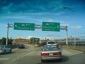
Interstate 195 (I-195) is an Interstate Highway running a combined 44.23 miles (71.18 km) in the U.S. states of Rhode Island and Massachusetts. It travels from a junction with I-95 in Providence, Rhode Island, east to a junction with I-495 and Route 25 in Wareham, Massachusetts. It runs east–west and passes through the cities of Fall River, Massachusetts, and New Bedford, Massachusetts. I-195 is occasionally referred to as the East Providence Expressway, but the name is not commonly used outside of the Providence area.
I-195 provides a major direct highway route from New York to Cape Cod via I-95 through Providence as well as for travelers coming from Connecticut, western Massachusetts and other Rhode Island points. Its major junction with I-95 in Downtown Providence provides a direct connection, since improved with the section in downtown Providence being replaced and moved to the south to lie just south of the Fox Point Hurricane Barrier.
Route description
I-195 begins at I-95 at a semi-directional T interchange, known as the Iway Project. The road begins concurrent with US Route 6 (US 6). From there it continues across the Providence River via the Providence River Bridge where it picks up US 44 and US 1A. The road continues into East Providence and all three roads respectively leave the freeway. From there it enters Seekonk, Massachusetts and continues east to Fall River where it has a brief concurrency with Route 24. It then continues through southeastern Massachusetts passing through New Bedford where it has an interchange with Route 140. From there it turns northeast and ends at I-495 and Route 25 with a trumpet interchange.
History
Predating I-195 were two sections of road—Fox Point Boulevard and the Washington Bridge. The Washington Bridge, crossing the Seekonk River between Providence and East Providence, was opened on September 25, 1930, replacing an 1885 swing bridge with a higher bascule bridge. A new eastbound bridge opened in November 1968.[3]
Fox Point Boulevard, later George M. Cohan Boulevard, was a surface boulevard connecting the Washington Bridge west to the Point Street Bridge and downtown Providence. It was built with no cross traffic by using U-turn ramps in the median to reverse direction. This was the last part in Providence to be built as a freeway, opened in December 1968.
The first freeway section came off the west end of Cohan Boulevard and over the Providence River, ending at the one-way pair of Pine Street and Friendship Street, which opened in November 1958. The ramp to Pine Street has been closed, but the entrance from Friendship Street still exists. The I-95 interchange at this end opened in fall 1964; the Pine Street ramp was kept for a while.
The next section to be constructed was the part in East Providence. It opened to the last exit before the state line on December 15, 1959, and was extended into Massachusetts by August 1960.
Before the Interstate Highway System numbering was decided upon, I-195 was planned as a relocation of US 6; in fact, all but the last section was signed as US 6 when built (the first section only eastbound though). In 1957, the number Interstate 95E was assigned, as all intercity routes were numbered before the three-digit Interstate numbering was chosen, and the Providence-New Bedford route was too long to be considered intracity. The I-195 designation was assigned in 1959 with the final numbering. At some time after 1976, the definition of I-195 was extended east to I-495 (which was itself extended).
I-195 still carries US 6, now in both directions, from I-95 to the last interchange before Massachusetts. It also carries US 1A and US 44 over the Washington Bridge and its approaches, though the former has almost no signs.
Iway
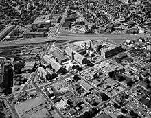
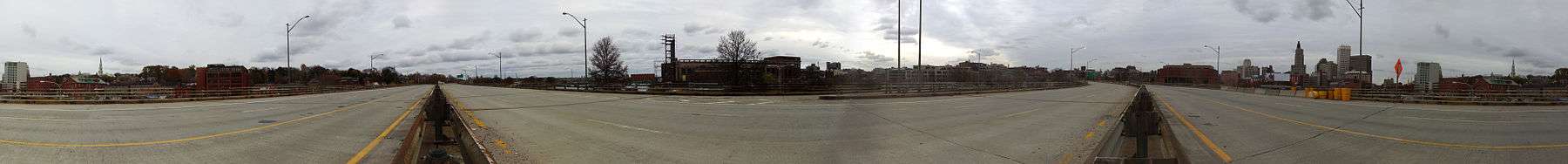
I-195's stretch through Providence was reconstructed because of sharp curves and the way the road cuts through part of the city. The relocation made the segment safer for traffic, reunified the Jewellery District with Downcity Providence, and freed up more space. In the process, some 35 buildings, housing over 80 businesses and six residences were demolished.[4] The new stretch of highway is called the Iway by the Rhode Island Department of Transportation and includes a signature bridge over the Providence River[5] as well as a landscaped pedestrian walkway over the highway. It connects India Point Park to the Fox Point neighborhood. The IWay was opened in 2009 and estimated to have cost $446 million. The demolition of the old road is to be completed by 2012.[6]
Exit list
All interchanges in Massachusetts were to be renumbered to mileage-based numbers under a project scheduled to start in 2016, however that project now has been indefinitely postponed by MassDOT.[7][8] All interchanges in Rhode Island will be renumbered to mileage-based numbers by 2018 under a plan announced by RIDOT in March 2016.[9]
| State | County | Location[2] | mi[1][2] | km | Exit[10] | Destinations[10] | Notes |
|---|---|---|---|---|---|---|---|
| Rhode Island | Providence | Providence | 0.00 | 0.00 | – | Western terminus of and concurrency with US 6; exit 20 on I-95 | |
| 0.40 | 0.64 | 1A | Point Street | Westbound exit and eastbound entrance | |||
| 0.80 | 1.29 | – | Westbound exit and eastbound entrance; exit 19 on I-95 | ||||
| 1B | Eddy Street | To Rhode Island Hospital; westbound exit only | |||||
| Providence River | 0.80– 1.00 | 1.29– 1.61 | Providence River Bridge (Iway) | ||||
| Providence | 1.10 | 1.77 | 2 | Gano Street / India Street | Eastbound exit only | ||
| 1.30 | 2.09 | 2 | Western terminus of concurrency with US 1A / US 44; westbound exit and eastbound entrance | ||||
| 1.50 | 2.41 | 3 | Gano Street – India Point | Westbound exit and entrance | |||
| Seekonk River | 1.60– 1.80 | 2.57– 2.90 | Washington Bridge | ||||
| East Providence | 1.80 | 2.90 | 4 | Eastern terminus of concurrency with US 44; eastbound exit and westbound entrance | |||
| 1.90 | 3.06 | 5 | Eastbound exit and westbound entrance; west end of Route 103 | ||||
| 2.40– 3.10 | 3.86– 4.99 | 6 | Warren Avenue / Broadway / Pawtucket Avenue – East Providence | Westbound access to US 44 and Route 103 | |||
| 3.30 | 5.31 | 7 | Eastbound exit and westbound entrance via flyover ramps | ||||
| 3.50 | 5.63 | 8 | Eastern terminus of concurrency with US 6 / US 1A; eastbound exit and westbound entrance | ||||
| 4.30 0.000 | 6.92 0.000 | Rhode Island–Massachusetts state line | |||||
| Massachusetts | Bristol | Seekonk | 0.581 | 0.935 | 1 | ||
| Swansea | 4.621 | 7.437 | 2 | Northern terminus of Route 136 | |||
| 7.470 | 12.022 | 3 | |||||
| Somerset | 9.849 | 15.850 | 4 | Signed as Exits 4A (west) and 4B (east) westbound | |||
| Taunton River | Charles M. Braga Jr. Memorial Bridge | ||||||
| Fall River | 11.984 | 19.286 | 5 | ||||
| 12.439 | 20.019 | 6 | Pleasant Street (westbound) / Hartwell Street (eastbound) – Downtown Fall River | Shared ramp with Exit 7 | |||
| 12.711 | 20.456 | 7 | Northern terminus of Route 81; shared ramp with Exit 6 | ||||
| 13.769 | 22.159 | 8A | Western end of concurrency with Route 24 | ||||
| 14.609 | 23.511 | 8B | Eastern end of concurrency with Route 24 | ||||
| Westport | 15.354 | 24.710 | 9 | Sanford Road – North Westport | Eastbound exit only | ||
| 16.343 | 26.302 | 10 | Northern terminus of Route 88 | ||||
| Dartmouth | 19.433 | 31.274 | 11 | Reed Road – Hixville, Dartmouth | Signed as Exits 11A (south) and 11B (north) westbound | ||
| 21.979 | 35.372 | 12 | Faunce Corner Road / Faunce Corner Mall Road – North Dartmouth | Signed as Exits 12A (south) and 12B (north) westbound | |||
| New Bedford | 23.768 | 38.251 | 13A | ||||
| 23.778 | 38.267 | 13B | |||||
| 24.627 | 39.633 | 14 | Penniman Street | Eastbound exit and westbound entrance | |||
| 25.087 | 40.374 | 15 | Southbound exit to Route 18 south; northbound entrance from Route 18 north | ||||
| 25.367 | 40.824 | 16 | Washburn Street | Eastbound exit and entrance | |||
| 25.632 | 41.251 | 17 | Coggeshall Street | Westbound exit and entrance | |||
| Fairhaven | 27.251 | 43.856 | 18 | Northern terminus of Route 240 | |||
| Plymouth | Mattapoisett | 30.911 | 49.746 | 19A | North Street – Mattapoisett | ||
| 30.922 | 49.764 | 19B | North Street – North Rochester | ||||
| Marion | 35.133 | 56.541 | 20 | ||||
| Wareham | 39.233 | 63.139 | 21 | ||||
| 39.911 | 64.231 | 22A | Western terminus of Route 25; Exit 1 on Route 25 | ||||
| 39.93 | 64.26 | 22B | Southern terminus of I-495; Exit 1 on I-495 | ||||
1.000 mi = 1.609 km; 1.000 km = 0.621 mi
| |||||||
See also
 Massachusetts portal
 Rhode Island portal
 U.S. Roads portal
References
- 1 2 3 Google (January 19, 2016). "East Providence Expressway" (Map). Google Maps. Google. Retrieved January 19, 2016.
- 1 2 3 4 MassDOT Planning Division. "Massachusetts Route Log Application". Massachusetts Department of Transportation. Retrieved August 21, 2014.
- ↑ Archived November 5, 2004, at the Wayback Machine.
- ↑ Sabar, Ariel (October 3, 1999). "Highway Blues". The Providence Journal. Archived from the original on March 6, 2004. Retrieved May 12, 2008.
- ↑ Staff (2006). "Moving and setting the Iway I-195 Providence River Bridge". Rhode Island Department of Transportation. Retrieved September 26, 2006.
- ↑ "195 Relocation Background". Providence College. Retrieved May 26, 2007.
- ↑ Commonwealth of Massachusetts (2015). "COMMBUYS - Bid Solicitation FAP# HSIP-002S(874) Exit Signage Conversion to Milepost-Based Numbering System along Various Interstates, Routes and the Lowell Connector". Retrieved January 6, 2016.
- ↑ Robert H. Malme (2016). "Massachusetts Interstate Current and Future Exit Lists". Retrieved October 10, 2016.
- ↑ WPRI Eyewitness News (2016). "RI Set to Renumber All Its Highway Exit Signs". Retrieved March 30, 2016.
- 1 2 Massachusetts Department of Transportation. "Exit Numbers and Names: Route I-195 (Seekonk to Wareham)". Retrieved August 21, 2014.
External links
- RIDOT - Relocation of the I-95/I-195 Interchange
- Kurumi
- Bostonroads.com - East Providence Expressway
- Bostonroads.com - I-195 in Massachusetts
- Mass. I-195 Current and Speculative Future Exit Numbers List
| ||