Itaparica Island
- For the Brazilian footballer, see Manoel dos Santos Filho.
| Native name: <span class="nickname" ">Itápirika | |
|---|---|
 Map of Itaparica Island | |
 Itaparica | |
| Geography | |
| Location | Baía de Todos os Santos, Atlantic Ocean |
| Coordinates | 12°59′00″S 38°40′00″W / 12.98333°S 38.66667°WCoordinates: 12°59′00″S 38°40′00″W / 12.98333°S 38.66667°W |
| Total islands | One |
| Administration | |
|
Brazil | |
| State | Bahia |
| Demographics | |
| Population | 55,000 |

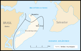
Itaparica is an island located at the entrance of Todos os Santos Bay on the coast of the Atlantic Ocean in the state of Bahia, Brazil. It is located about 10 kilometres (6.2 mi) from the city of Salvador, Bahia and covers 146 square kilometres (56 sq mi). There are two municipalities on the island: Vera Cruz (87% of the land area) and Itaparica (13%). Itaparica has 40 kilometres (25 mi) of beaches suitable for tourists and exuberant tropical vegetation. Itaparica is the largest maritime island in Brazil.[1]
Itaparica is known for hosting the Sul America Open tennis competition (1986-1990). It is the former home of the tennis tournament, the ATP Itaparica.
One of its most famous citizen was Brazilian writer João Ubaldo Ribeiro
Access
Itaparica can be reached in about one hour by ferry from Salvador. The smaller passenger-ferry departs from near the Mercado Modelo, while the larger car-ferry goes from about 2 kilometres (1.2 mi) north to Bom Despacho. The state of Bahia is considering constructing a (11.6 kilometres (7.2 mi) bridge between Salvador and Itaparica.
References
- ↑ "Vera Cruz" (in Portuguese). Salvador, Bahia: State of Bahia. 2014. Retrieved 2014-12-16.
| Wikimedia Commons has media related to Itaparica. |