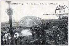
Japoma Bridge

The Japoma Bridge (also known as the Edea German Bridge or the German Bridge) is a railway bridge over the Sanaga River near Edea, Cameroon. [1]
History and technical details
-

Constructing the bridge, floating the iron superstructure over the river.
-

Diagram showing the measurements of the bridge, from a German book. 1916
-
Modern view of the bridge.
The steel arch bridge was designed and built by the Gutehoffnungshütte of Oberhausen. Before being delivered, the bridge was assembled in Germany so it could be tested. It was then disassembled and transported in pieces by boat to Cameroon in 1911. It measures 160m in length, and was the largest in Africa at the time of erection. The vertical columns starting at the arch grille are used as a suspension for the roadway. One half of the arch was first assembled on the ground and the other built on floating barges, which were then correctly assembled. It remains an architectural relic of the German colonial era in Cameroon. [2]
The strategic location of the bridge was seen during the First and Second Battles of Edea during World War I. The bridge was also visited by the entire German crew of the Wahehe, with certain officers going right up to the bank of the river, August 2, 1937, in what was thought to be a reconnaissance of the area. [1]
The bridge was the only passage point over the Sanaga Rivery for trains, vehicles and pedestrians until the early 80s. It is now used as a footpath and cycle track. [3]
References
- 1 2 SAH, LÉONARD I. (1982). "Activités allemandes et germanophilie au Cameroun (1936-1939)" [German and Germanophile Activities in Cameroon (1936-1939)]. Rev. franc. d'Hist. d'Outre-Mer (in French). 69 (255): 129–144. Retrieved 22 March 2014.
- ↑ "Pont de la culture à Edea" [Cultural Bridge in Edea]. Goethe-Institut. 2012. Retrieved 22 March 2014.
- ↑ Elodie N. BODOLO (2012). "Expositions Les festivités du centenaire du pont d'Edéa annoncées" [Exhibition- Festivities for the centenary of the Edea Bridge announced]. Mboa Live (in French). Retrieved 22 March 2014.
Coordinates: 3°48′18″N 10°07′26″E / 3.80500°N 10.12389°E