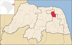
João Câmara, Rio Grande do Norte
| Municipality of João Câmara | |||
|---|---|---|---|
| |||
|
Nickname(s): "Terra dos abalos" (Earthquakes land) "Capital do mato grande" (Mato Grande's capital) | |||
 Location in Rio Grande do Norte and Brazil | |||
| Coordinates: 05°32′16″S 35°49′12″W / 5.53778°S 35.82000°WCoordinates: 05°32′16″S 35°49′12″W / 5.53778°S 35.82000°W | |||
| Country | Brazil | ||
| Region | Northeast | ||
| State | Rio Grande do Norte | ||
| Founded | 29 October 1928 | ||
| Government | |||
| • Mayor | Ariosvaldo "Vavá" Targino de Araújo (DEM) | ||
| Area[1] | |||
| • Total | 714.951 km2 (276.044 sq mi) | ||
| Elevation | 160 m (520 ft) | ||
| Population (2012)[2] | |||
| • Total | 34,057 | ||
| • Density | 47.6/km2 (123/sq mi) | ||
| Time zone | UTC-3 (UTC-3) | ||
| • Summer (DST) | UTC-2 (UTC-2) | ||
| HDI (2010) | 0.595 – medium[3] | ||
| Website | www.joaocamara.rn.gov.br | ||
João Câmara is a municipality in the state of Rio Grande do Norte, Brazil.
References
- ↑ IBGE (10 October 2002). "Área territorial oficial". Resolução da Presidência do IBGE de n° 5 (R.PR-5/02). Retrieved 5 December 2010.
- ↑ "ESTIMATIVAS DA POPULAÇÃO RESIDENTE NOS MUNICÍPIOS BRASILEIROS COM DATA DE REFERÊNCIA EM 1º DE JULHO DE 2012" (PDF). Instituto Brasileiro de Geografia e Estatística. 30 August 2011. Retrieved 31 August 2012.
- ↑ "Ranking decrescente do IDH-M dos municípios do Brasil". Atlas do Desenvolvimento Humano. Programa das Nações Unidas para o Desenvolvimento (PNUD). 2010. Retrieved 4 September 2013.
This article is issued from Wikipedia - version of the 5/12/2016. The text is available under the Creative Commons Attribution/Share Alike but additional terms may apply for the media files.
.png)
.png)