Ketchikan Harbor Seaplane Base
| Ketchikan Harbor Seaplane Base | |||||||||||
|---|---|---|---|---|---|---|---|---|---|---|---|
 | |||||||||||
| IATA: WFB – ICAO: none – FAA LID: 5KE | |||||||||||
| Summary | |||||||||||
| Airport type | Public use | ||||||||||
| Serves | Ketchikan, Alaska | ||||||||||
| Elevation AMSL | 0 ft / 0 m | ||||||||||
| Coordinates | 55°20′40″N 131°39′48″W / 55.34444°N 131.66333°W | ||||||||||
| Map | |||||||||||
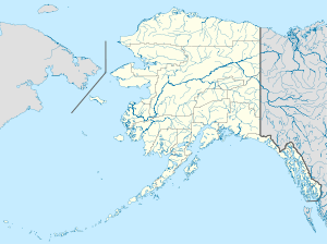
 5KE Location of airport in Alaska | |||||||||||
| Runways | |||||||||||
| |||||||||||
| Statistics (2006) | |||||||||||
| |||||||||||
Ketchikan Harbor Seaplane Base (IATA: WFB, FAA LID: 5KE) is a privately owned, public use seaplane base located at the harbor of Ketchikan,[1] a city in the Ketchikan Gateway Borough of the U.S. state of Alaska. It is located near the Ketchikan International Airport, which also has its own seaplane landing area. Prior to the opening of the Ketchikan International Airport in 1973, scheduled passenger seaplane service was operated with amphibian aircraft between the seaplane base and the Annette Island Airport located approximately 20 miles south as this land plane airfield previously served as the primary airport for Ketchikan with scheduled airline flights being operated by Pan American World Airways, Pacific Northern Airlines and Western Airlines into Annette Island over the years.
As per Federal Aviation Administration records, the airport had 38,945 passenger boardings (enplanements) in calendar year 2008,[2] 40,462 enplanements in 2009, and 43,737 in 2010.[3]
Facilities and aircraft
Ketchikan Harbor Seaplane Base has one seaplane landing area designated NW/SE which measures 10,000 x 1,500 ft. (3,048 x 457 m). For the 12-month period ending December 31, 2006, the airport had 10,450 aircraft operations, an average of 28 per day. At that time there were 51 aircraft based at this airport.[1]
Airlines and destinations
The following airlines offer scheduled passenger service:
| Airlines | Destinations |
|---|---|
| Pacific Airways | Craig, Hollis, Metlakatla, Thorne Bay [4] |
| Promech Air | Craig-Klawock, Hollis-Thorne Bay, Metlakatla [5] |
| Taquan Air | Coffman Cove, Craig/Klawock, Edna Bay, Hollis, Hydaburg, Hyder, Metakatla, Naukati, Point Baker, Port Protection, Thorne Bay, Whale Pass [6] |
| Carrier | Passengers (arriving and departing) |
|---|---|
| Pacific | 13,660(63.93%) |
| PM Air, LLC | 5,910(27.64%) |
| Venture | 1,800(8.43%) |
| Rank | City | Airport | Passengers |
|---|---|---|---|
| 1 | Metlakatla, AK | Metlakatla Seaplane Base (MTM) | 3,000 |
| 2 | Craig, AK | Craig Seaplane Base (CGA) | 3,000 |
| 3 | Thorne Bay, AK | Thorne Bay Seaplane Base (KTB) | 2,000 |
| 4 | Hollis, AK | Hollis Seaplane Base (HYL) | 2,000 |
See also
- Ketchikan International Airport (IATA: KTN, ICAO: PAKT, FAA LID: KTN) located at 55°21′15″N 131°42′40″W / 55.35417°N 131.71111°W
References
- 1 2 3 FAA Airport Master Record for 5KE (Form 5010 PDF). Federal Aviation Administration. Effective May 31, 2012.
- ↑ "Enplanements for CY 2008" (PDF, 1.0 MB). CY 2008 Passenger Boarding and All-Cargo Data. Federal Aviation Administration. December 18, 2009. External link in
|work=(help) - ↑ "Enplanements for CY 2010" (PDF, 189 KB). CY 2010 Passenger Boarding and All-Cargo Data. Federal Aviation Administration. October 4, 2011. External link in
|work=(help) - ↑ "Flight Schedules: Effective July 1, 2012 through August 15, 2012.". Pacific Airways. Retrieved August 2, 2012.
- ↑ "Scheduled Flights: Effective July 1 ~ August 20, 2012". Promech Air. Retrieved August 2, 2012.
- ↑ "Summer Flight Schedule: Effective May 13 – September 15, 2012". Taquan Air. Retrieved August 2, 2012.
- 1 2 "Ketchikan, AK: Ketchikan Waterfront Seaplane Base (WFB)". Bureau of Transportation Statistics (BTS), Research and Innovative Technology Administration (RITA), U.S. Department of Transportation. December 2011.
External links
- Topographic map from USGS The National Map
- Resources for this airport:
- FAA airport information for 5KE
- AirNav airport information for 5KE
- ASN accident history for WFB
- FlightAware airport information and live flight tracker
- SkyVector aeronautical chart for 5KE