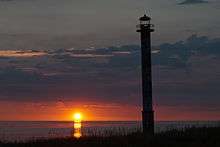
Kiipsaare Lighthouse
 Kiipsaare Lighthouse in 2013 | |
 Estonia | |
| Location |
Saaremaa Estonia |
|---|---|
| Coordinates | 58°29′45″N 21°50′28″E / 58.49583°N 21.84111°ECoordinates: 58°29′45″N 21°50′28″E / 58.49583°N 21.84111°E |
| Year first constructed | 1879 (first) |
| Year first lit | 1933 (second) |
| Deactivated |
1933 (first) 1992 (second) |
| Foundation | concrete |
| Construction | concrete tower |
| Tower shape | cylindrical tower with balcony and lantern |
| Markings / pattern | white and black horizontal bands |
| Height | 25 feet (7.6 m) |
| Focal height | 85 feet (26 m) |
| Range | 15 nautical miles (28 km; 17 mi) |
| Characteristic | Fl W 4s. |
| Admiralty number | C3716 |
| ARLHS number | EST-077 |
| Estonia number | EVA 921[1] |
Kiipsaare Lighthouse is located on the tip of Harilaid Peninsula in Saaremaa, Estonia in the territory of Vilsandi National Park.
The lighthouse was built from reinforced concrete in 1933. Its purpose was to warn mariners on the Baltic Sea about the dangers in the vicinity of the peninsula and to be of assistance in taking bearings. At that time the 25-metre-high (82 ft) lighthouse was between 100 to 150 metres (330 to 490 ft) inland, but due to erosion it is now a few meters offshore. A lack of supporting ground has caused the lighthouse to lean.[2]

While in 1988 the waterline was still 11 metres (36 ft) from the lighthouse, by the early 1990s the sea had already reached the lighthouse and it started to incline. Because of this the generator was removed in 1992 and Kiipsaare lighthouse remained in the records as a daymark until 2009.[3]
See also
References
- ↑ Rowlett, Russ. "Lighthouses of Southwestern Estonia". The Lighthouse Directory. University of North Carolina at Chapel Hill. Retrieved November 22, 2015.
- ↑ Eesti Loodus, Kiipsaare rannad ja tuletorn, K. Orviku, H. Tõnisson 2009. 5: 6–13.
- ↑ Eesti Post, Stamps, Kiipsaare Lighthouse
External links
- Estonian lighthouses list Maritime Administration (in Estonian)
| Wikimedia Commons has media related to Kiipsaare lighthouse. |